Friday 9/1/00 21 miles/3621 Total. 223 Trail Days. Pinkham Notch to US 2 near Gorham, NH.
Another hot day for high adventure. Betty had me on the trial before 6:30AM. The climb up Wildcat Mountain was long and steep. Wildcat Mountain is a popular ski area with five cleverly named peaks: Peak A thru Peak E. When we first saw the parking area for Wildcat, Betty and I both realized that we had been here about 12 years ago. We had come here to ski with friends, Roy and Joan Burgess.
Now I have hiked up Wildcat Mountain and pass the top of the ski lifts. Then a steep 1200 foot drop into Crater Notch and back up and over a series of Carter peaks. It was five miles to get over the Carter family. The 1300 foot descent to Imp Shelter was another steep one. While descending I was overtaken by “Commodore”. We hiked together for almost an hour then he stopped at Imp Shelter to get water and would stop for the night a few miles down the trail.
Eventually, I climbed over Mount Moriah and started a six mile descent to US Route 2. Betty had left the car at the trailhead parking area and walked back to the RV. Earlier in the day she moved the rig to Timberland RV Park. Our little home was all hooked up when I arrived. It was a long haul with nearly 5000 feet of vertical climbing.
Betty: Saturday 9/2/00 Chuck left this morning for an area that will take him three days to hike and he will have two overnights, with big pack and all the trimmings. He was busy packing up this morning and was on the trail about 10:00. We are hoping he will have good weather, but the forecast is for scattered showers. I will pick him up on Hwy 26 in Maine on Monday. Scott Sheldon is planning to come up and hike again for a day or two. He will be visiting family in Maine. Mae, “Crabby Trails”, (Chuck’s sister and my best friend) is coming back in about a week or so and we’re sure looking forward to her visit. She will be at Katahdin with us.
Saturday 9/2/00 10 miles/3631 Total. 224 Trail Days. US 2 (Gorham, NH) to Dream Lake.
Betty helped me cram food, tent, sleeping bag, water filter, etc. into my pack for the three day trip across a remote mountainous area. The two thousand foot climb up Mount Hayes was long but not steep. On the way up I was overtaken by two young Quebecqois (French Canadians). As they approached, I heard them speaking French and when they passed, I whipped my best French on them. Thirty seconds later, after exhausting all of their language that I could remember, we switched to English. They and four others, who followed, live east of Montreal. They were here for the three day hike through Mahoosuc Notch. They were carrying huge packs, but quickly climbed out of view in front of me. Later, I found that those huge packs were loaded with all types of mouth watering delicacies.
It started raining early in the afternoon making rocks and roots slick and muddy. Over Cascade Mountain through Trident Pass and eventually to Dream Lake, my intended campsite for the night. It was still raining and this lake was no dream. It had a marshy shoreline and no suitable campsite was obvious. Finally, I located a site someone had used some time ago. I was about a hundred feet off the trail and several hundred feet into thick woods from the dream lake. Setting up camp in a downpour has never been one of my better activities. Within about two minutes the tent was up, I tossed all my gear inside and crawled in behind it. I was glad this site was back in the woods and out of view from the trail, it was really a sloppy job. But, it was raining and I was inside and I didn’t have to look at it. As I was cooking my dinner under the little vestibule, I heard voices. Peering from inside the tent, I could see two figures, in rainsuits with hoods over their heads, moving back and forth on the trail. It was obvious they were searching for a campsite. I yelled to them and offered a sort of flat spot near mine. They took it. It was “Sirroco” and “Aimless”, two southbound ladies I had met a couple of months ago near Roan Mountain. At that time they were hiking south to Springer Mountain. They then did a “wrap around” by driving to Mount Katahdin, Maine and are hiking south to their starting point at Harpers Ferry, WV. They spent more time setting up their rather large tent, it looked better than my sad operation. My skillet potatoes were great, I was asleep before dark, and it was still raining.
Betty: Sunday 9/3/00 It is indeed a day that the Lord has made.
I searched the phone book for a Lutheran church and found one in Berlin, NH which is about 10 miles north of Gorham. I called yesterday and talked to the pastor and could tell right away that this was going to be a great experience. For those of you in Lime Springs – this is St. Paul’s Lutheran and it’s on Norway street and you turn at Oleson’s Norwegian Village (store). Today, as I pulled into the parking lot, I saw a gentleman getting out of his car – and to my surprise it was “Jimmy B”, a hiker on the trail who recently had some health problems and had to stop hiking, but is now helping “slack” other hikers. He had “Tigger” (we first mentioned “Tigger” in New York/New Jersey and then saw her again at the Hiker Feed about a week ago) and “Slug”, both thru-hikers. What excitement. They are camping in Gorham, but at a different campground. It was great to see them. We all sat together in church. I met the most wonderful people. The congregation welcomed us into their fold, as did Pastor and Mrs. Stone. We all had coffee and goodies after the service and visited – it was really hard to leave!!! Pastor Stone said I could come back on Monday and update my website. So you’ll be reading this soon. Is there any doubt that God is at work in our lives. We are very blessed and thankful.
I got back to the campground and Claire, who is working as a campground volunteer had checked out our site. She came by and we talked and she offered to check to see if my update had taken, it didn’t – so she told me I could come by her place and try to update it again. Sometimes I have a problem getting the updates to take, and this evidently was one of those times. Claire and her husband, RV “full time” and work at some of the campgrounds they stay in. They were going to be here long enough that they had a phone connected. She’s been telling me all about volunteering and also that they have already visited the Gasp* peninsula. While at Claire’s, I couldn’t get the journal to update, but did figure out how to delete the photo album, so maybe the next time I try to update the journal, it will work. Computers, I love them and hate them.
Sunday 9/3/00 11 miles/3642 Total. 225 Trail Days. Dream Lake (NH) to Full Goose Shelter (ME)
At 6AM it was still raining. I dressed inside the tent then stuck all my belongings in the pack. Once outside, I dropped the tent and quickly shoved the wet thing in it’s stuff sack. This wet sack then went into the pack. I said good-bye to “Sirroco” and “Aimless”, still snug in their dry tent and I was on my way.
I passed the Gentian Pond Shelter at 9AM. Section hikers, “Stringer” (I think) and Victoria were there fixing breakfast. “Stringer” is a member of the International Appalachian Trail Chapter in Maine. A resident of Connecticut, he is very knowledgeable about the IAT in both Maine and Canada.
A few miles later I met “Wishbone” and “Odd Rod”, both northbound thru-hikers. “Wishbone”, Monica Miller, is also a Florida Trail member. She lives near Jacksonville. We talked for several minutes and took some pictures.
One mile on up the trail, I crossed the state line and entered Maine. As usual, in this area, the trail is rugged with lots of ups and down, lots of rocks and roots, and for two days lots of rain. Crossing the two peaks of Goose Eye Mountain, the trail was nearly at treeline. The plan was to stay at Full Goose Shelter for the night. The area was full of campers when I arrived at 6PM. Twelve hikers had their sleeping bags in the shelter and there were over a dozen tents behind it. My wet tent went up on a platform which also served as a cooking counter and dining table. While preparing dinner (red beans and rice), a young woman hiker walked through the area looking for a spot. I pointed out a flat area adjacent to my site. She immediately called that spot, “home”. Her name is Monica Morris and she is a senior staff editor at Backpacker Magazine. I think she is doing an article on hiking the Mahoosuc Notch.
It continued raining through the night, I slept well.
Monday 9/4/00 10 miles/3652 Total. 226 Trail Days. Full Goose Shelter to Grafton Notch.
It was still raining as the overcast sky got lighter with the dawn. It was another wet pack job. I was just leaving as Monica stepped out of her tent. I asked if it was OK to get a picture. She must be a hardcore backpacker because most women would have had harsh words for such a request the instant they crawled out of a tent, but she smiled, flashed her “Backpacker Magazine” name tag and I snapped the picture. I was the first to depart the camp.
An hour later, the rain stopped and I entered the much talked about, “Mahoosuc Notch”. This mile long canyon is about 200 feet wide and has vertical rock walls over five hundred feet high on both sides. During the past several thousand years, large chunks of rock have fallen to the bottom of this notch. These rocks are the sizes of houses, buses and VW’s and they are piled high for a full mile through this narrow slot. The trail goes over, under, around and through these huge rocks. It is a large puzzle to figure out how to negotiate each obstacle. There are several ways through many of the blockages. Some may require climbing 20 feet up over a vertical wall using tiny cracks for handholds, others require long stretches or jumps. Two times I removed my pack and pushed it through a small hole then squeezed through myself.
While having fun in this large natural playground, my Quebecqois friends, Oliver and Pierre, caught up to me. We had all done some mountain climbing in the past and found those techniques enhanced our enjoyment. A few times we negotiated the same obstacle more than one way. It was a fun time and would have been even better without a pack. I spent about an hour and forty-five minutes playing with this one mile stretch.
The steep climb out of the notch up Mahoosuc Arm took the remainder of the morning. Then it was over Speck Mountain and a gradual 2500 foot descent over three miles into Grafton Notch to meet Betty at the trailhead. I arrived about an hour earlier than expected, and Betty was there.
She had arranged to meet our friends, Scott and Missy Sheldon, their son, Luke and Scott’s parents, for dinner at the “Moose’s Tale”. I had beer and Maine Lobster, lots of both. I don’t know what anybody else had, but it was a good time.
Tuesday 9/5/00 10 miles/3662 Total. 227 Trail Days. Grafton Notch to East B Hill Road.
It was a steady climb up Baldpate Mountain. The West and East Peaks are at about 3800 feet and they are covered with flat rock. It was cool at about 45 degrees and the wind on these unprotected peaks was about 25 mph. I dug out my windbreaker. The views in all directions were wonderful. The green hills and mountains of Maine go, seemingly, forever.
At Frye Notch Lean-to, about 10 hikers had all stopped for lunch. “Mississippi Hiker” was there, also “Wishbone”.
“Mississippi Hiker” and I hiked the last mile of the day together and met his brother “Golden Eagle” who took us back to the Stony Mountain RV park. During the day, Betty had moved our RV to this park. “Golden Eagle”, “Virginia Bluebird” and “Mississippi Hiker” were parked next door to us and invited Betty and me over for dinner. Good food, good wine and good company. Life on the trail is good this day.
Wednesday 9/6/00 10 miles/3672 Total. 228 Trail Days. East B Hill Road to South Arm Road.
“Mississippi Hiker” (“MH”) rode to the trailhead with Betty and me. “MH” and I planned to hike together and meet Betty after a short day.
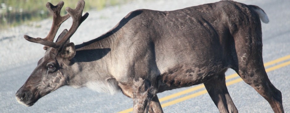
It was 8AM, we had been on the trail about half an hour when “MH” stopped abruptly. He quietly said, “There is a Moose just around this bend in the trail”. About 40 feet in front of us was a bull moose with a huge rack. He took note of us and moved about 15 feet. Some leaves were dangling from his mouth as he stood there posing for a few pictures. This big animal was still there when we decided to hike on up the trail.
We were over Wyman Mountain and down to Hall Mountain Lean-to (shelter) well before lunch time. Several hikers were there. An older guy, “Skate”, looked familiar. He said we had met near the “Smokies” when he was hiking south from Harpers Ferry. He is now hiking south from Katahdin to Harpers Ferry.
“MH” and I crossed Sawyer Notch then climbed 1300 feet to the top of Moody Mountain and stopped for lunch with a great view on this beautiful clear, but cool day.
It was a short hike down to South Arm Road. We were almost an hour earlier than planned, so was Betty. She drove up about three minutes after we arrived. The day was exceptional: short hike, perfect weather, friendly terrain and we saw a moose.
Thursday 9/7/00 13 miles/3685 Total. 229 Trail Days. South Arm Rd. to State Rd 17.
Betty had “MH” and me on the trail before 8AM. It was another beautiful day, clear and cool with unlimited visibility. The first steps were up and the ascent continued for three miles and an elevation gain of 2000 feet. On the top of Old Blue Mountain we found “Buck”, “Frito”, “Bean” and “Hogie”. They had slept under the stars and were just breaking camp. The night was windy, cool and wonderful, they reported. The view from the mountain top was great with Maine’s mountains and lakes continuing endlessly in all directions.
We continued across Elephant Mountain at a brisk but comfortable pace. The trail was now in the Bemis Mountain Range. It was 2:30pm when we arrived at State Road 17. Wayne and Mary were waiting for us and they gave the four mountain top campers a ride to Oquossoc. Even though it was ten miles out of his way, Wayne never mentioned it. Mary offered them water and chips.
When we reached our RV in the town of Mexico, Maine, Betty had refreshments waiting for us. She had asked the Town Manager, Joe Derouche, for permission to park the RV overnight in the lot behind the town hall. She told him about our hike and he agreed. He gave her two T-shirts for “the hikers” and said he would like to send a reporter to talk with us.
Eileen Adams from Sun Journal joined us shortly after we arrived. She was interested in the hikes that “MH” and I were doing and in our rather unique support arrangements. She received some good input from Wayne, Mary and Betty about their vital roles. Before Eileen left, Bruce, a reporter from a rival newspaper in Rumford, ME arrived. He got some basic facts about our trips, took a couple of pictures and we were off to eat at the Mexico Chicken Coop. We wanted to go to a Mexican restaurant, but there is no Mexican restaurant in Mexico.
Betty: However, Joe said he is working on getting a Mexican restaurant. They will also have a new super Wal-mart soon.
Friday 9/8/00 13 miles/3698 Total. 230 Trail Days. State Rd. 17 to State Rd. 4.
Again, Betty had “MH” and me on the trail before 8AM. It was another beautiful day and the easiest trail we have had in weeks. The total elevation gain was less than one thousand feet. “MH” and I chatted the miles away.
“Silver”, “Sweep” and “Pigpen” had spent the night on the shore of a picturesque little lake. We passed by as they were packing. Later, we hiked a while with “Good Foot”, but soon pulled away as we clipped off the miles.
We reached the end point an hour and a half early and realized we had not stopped to eat lunch. While waiting for our ride, “Mad Scientist” and “Smokin Joe” arrived. After talking with us a few minutes, they decided to hitch-hike into Rangeley, ME. Within two minutes these young, grubby, smelly guys were picked up by a lone young woman driving a convertible with the top down??
Wayne and Mary were right on time, again they gave some hikers a ride to a town that was out of their way; this time it was three southbounders.
We moved to Deer Farm RV Park as did the Howells, “Golden Eagle” (Wayne), “Virginia Bluebird” (Mary), and “Mississippi Hiker” (Harold). Betty fixed a great dinner T-bone steak, baked potato and salad. Life is good.
Betty: This RV park is another neat park. It sits on a hill above Kingfield. It is quiet, peaceful and is on the 45th parallel, that’s halfway between the North Pole and the Equator. It’s probably going to start to feel like the North Pole soon, but right now the temperature is great! There is a pond just across the road at which you may sight moose and loons. Also, of importance for me, is they have a modem hookup!!!! I saw two more moose this morning (9/9/00) after dropping the guys at their start point. It was a young moose and it’s mother. They were both in the road.
Saturday 9/9/00 24 miles/3722 Total. 231 Trail Days. State Rd. 4 to Caribou Valley Road.
Today promised to be a long hard day. We planned to hike 24 miles over six mountains, a total elevation gain of about 8,000 feet. Since the days are shorter now we knew an early start was essential if we hoped to finish before dark.
“Mississippi Hiker” (MH) joined us at 5:30 AM and Betty drove us to the trailhead. We were climbing up to Piazza Rock at 6:20AM. Then, it was a 2000 foot climb on up to the top of Saddleback Mountain. We were above treeline and in a cloud. Even though we were sweating from the steep climb, the wind near the rocky summit forced us to don our jackets. After a 500 foot climb over The Horn, we descended below treeline. After climbing over Saddleback Junior we descended 2000 feet and crossed Oberton Stream. We took a short break here to purify two liters of drinking water for each of us.
Of course, every time we go down we must climb back up. This time it was up Lone Mountain, then Spaulding Mountain and finally Sugarloaf Mountain. Sugarloaf is a popular ski area in Maine. The descent down to Caribou Valley Road was over 2 miles long and very steep in places. Betty met us with cold beer and a ride home.
It had been a long tiring day. Our pace had been brisk with few breaks, the longest being 20 minutes for lunch. It took just under eleven hours to do the 24 miles. We finished well before dark and we were glad to see Betty.
Betty: I hadn’t anticipated that they would be early and even though I was a half hour early they had already been there nearly an hour. They put their warm clothes on, but still probably got chilled waiting.
It’s Sunday now, “Swamp Eagle” and “MH” are on the trail. Today is a short day for them. We’ve invited “MH”, “Virginia Bluebird” and “Golden Eagle” over for dinner tonight – so I’d better get busy.
I went to Kingfield United Methodist Church this morning. Had a wonderful time and met a great group of folks. After church I went to North New Portland (our next stop) to scout out a place to park the RV. We will dry camp at least one day and maybe two. I found a Presbyterian Church that is used only occasionally and a library that is open on Saturdays and Wednesdays. They share a parking lot, which is nice and flat. The librarian, Jan Kooistra, was at the library and gave me permission to park in their lot. Well, we’ve said all along that the trip is really made by the wonderful people we meet along the way, and Jan is another example of the wonderful people we’ve met.
Sunday 9/10/00 9 miles/3731 Total. 232 Trail Days. Caribou Valley Road to Stratton Brook Pond Road. Sunday, easy day, late start. Wayne had us on the trail just after 9AM. He repeated his plans for the day several times, watch football, have a couple of cold beers. “Mississippi Hiker” and I were not phased, we had our own great day ahead. It was yet another perfect day and we only had nine miles. It would be a 2000 foot climb over Crocker Mountain, then a long gradual descent to our pick-up point. The trail was kind to us and we made good time. We arrived early and so did Mary.
On the drive back to the RV park, we saw a red fox. Also, Mary, an avid birder, helped “MH” and I identify a bird we had seen earlier. It was a White-winged Crossbill.
Betty fixed a great lasagna dinner for the five of us. We had a good time swapping stories.
Monday 9/11/00 18 miles/3749 Total. 233 Trail Days. Stratton Brook Pond Rd to Long Falls Dam Road. It was a 22 miles drive to get us on the trail, but Betty had us there at 7AM. In front of us were the renowned Bigelow Mountains. A 3000 foot climb put us above the treeline and on top of first West Peak, then Avery Peak. We were in the clouds and the wind was about 20 mph; we stopped to put on our wind breakers. “Mississippi Hiker” and I both like hiking above the treeline, it is exhilarating.
During the eleven mile descent we took a break on Little Bigelow Mountain and along came “Gaited Mule” and “Ram Kitten”. It had been over a month since we last saw “Gaited Mule”. He caught us up to date on the location and activities of many thru-hikers. He is temporarily being supported by Gordon and Sue. At East Falstaff Road we met this interesting brother and sister team. They have been supporting thru-hikers for years, mostly on the Pacific Crest Trail and the Continental Divide Trail. Earlier this season they supported “Grandma Soules” until she caught Lyme Disease and was forced to drop her AT attempt.
We were early, but Betty was waiting for us at Long Falls Dam Road. She had made arrangements to park both our RV and the Howell’s RV in a Library/Church parking lot in North New Portland. We met Jan and Donna who were working late at the library. They are great ambassadors for the State of Maine.
Tuesday 9/12/00 14 miles/3763 Total. 234 Trail Days. Long Falls Dam Rd. to Trail to Harrison’s Pierce Pond. As of today we have 2000 miles behind us on the Appalachian Trail. Someone painted “2000 miles” on the pavement at the trailhead to make certain this milestone did not pass unnoticed.
The trail today was nearly flat, the total elevation gain was less than 1,000 feet. In several places the trail follows a lakeshore and has a beautiful view across the water. The miles were easy and went by quickly. We met “Lone Wolf” and hiking partner who are now southbound after a flip flop from Harpers Ferry. I remembered meeting them earlier as they were hiking north, maybe in southern Virginia.
As we started today, Wayne (Golden Eagle) volunteered to slack (haul the packs of) “Gaited Mule”, “Big Dig”, “Ram Kitten”, “Turbo Turtle” and “Split Pea”. Their support van refused to go on Pierce Pond Road to meet them. Also, even before we started, we saw a large bull moose in a long bog. I think I got a decent picture.
The roads to the trail heads are getting longer and more remote; today’s trip was nearly 40 miles, one way.
Wednesday 9/13/00 15 miles/3778 Total. 235 Trail Days. Trail to Harrison’s at Pierce Pond to Moxie Pond Rd.
The convoy departed at 6AM in a light rain. Betty had identified a temporary parking area in Bingham, Maine and the Howells, Wayne (“Golden Eagle”), Mary (“Virginia Bluebird”), and Harold (“Mississippi Hiker”) followed us the twenty miles. Wayne and Mary then gave us all a 25 mile ride to the trailhead near Pierce Pond. Along the way a moose ran up the road in front of us. By now the rain had stopped. Betty and Mary planned to hike three miles with us to the Kennebec River.
It was a beautiful trail along Pierce Pond Stream. The air was clean and cool, the forest was very green with moss and ferns on the forest floor, green leaves overhead and green moss on tree trunks in between. Mary spotted a winter wren and several other birds. At the Kennebec River we waited for a canoe to ferry us across, two at a time. Wayne was there to give Betty and Mary a ride back to the RVs.
“Mississippi Hiker” and I hiked twelve more miles over Pleasant Pond Mountain and down the gradual descent to our meeting place at Moxie Pond. Betty was there to give us a 40 miles ride back to the RV, then it was 20 miles more to Balsam Woods Campground near Abbot, Maine. This expansive country is sparsely populated.
Thursday 9/14/00 18 miles/3796 Total. 236 Trail Days. Moxie Pond Rd. to Shirley Blanchard Rd.
The weatherman says that today will be our last good one for a while. Evidently, tropical storm Florence is moving out into the Atlantic and we will be getting some bands of rain.
Today is clear, sunny and great. Our first chore is to get over Moxie Bald Mountain at 2700 feet. It was an easy climb with great views in all directions from the summit. We can’t be certain, but we think we might have seen the top of Katahdin. It is about 60 miles as a loon flies.
The trail along Bald Mountain Stream was easy hiking and very scenic. Everyday more leaves are starting to turn to their autumn colors. At one point we saw fresh bear scat right on the trail. Later, hiking along the West Branch Piscataquis River, we were about 80 feet above the river looking down into Horseshoe Canyon. The afternoon sun shining on the water careening over rocks and on the already yellow ferns that lined the river was awesome. “Mississippi Hiker” and I met Betty at Shirley Blanchard Road.
After showers back at the RV park the three of us ate at the campground snack bar. We all had fresh lobster cooked right in front of us while we listened to tales of the north country. Great!!
Betty: Jay and Lynn are the owners of the campground. It is really a nice campground and very accessible. We have a nice pull thru site with water and electric. In their snack bar they serve, lobster, clams, hamburgers, etc. That’s a really nice touch. Today while scouting, I went past the “Pie Lady’s” house. She has rooms she rents to hikers and also runs a hiker shuttle. She also bakes and sells breads and pies. I stopped in to buy a pie (blueberry) and also talked to her about different routes in to the trail. “MH”, “Swamp Eagle”, Jay, Lynn, and Marc (another RVer) all had pie after dinner, and it was great!
Friday 9/15/00 13 miles/3809 Total. 237 Trail Days. Shirley Blanchard Rd. to Little Wilson Falls.
As predicted, it rained. Wet rocks and roots slow progress on the trail. “Mississippi Hiker” and I wore our rain parkas all day. Before noon we crossed Highway 15 and entered the much bally-hooed One Hundred Mile Wilderness. Signs warn all that enter to be well prepared.
For weeks, I have been expecting to meet “B & B” on their journey south from Cape Gaspe’, Quebec. They actually started at Springer Mountain, Georgia, hiked north to Harpers Ferry, WV then flipped to Cape Gasp* and are now hiking south to complete their trip at Harpers Ferry. The president of the International Appalachian Trail, Dick Anderson, has been keeping us posted on their progress. A few days ago he told Betty we should meet them near Monson, Maine. About one-half mile after we crossed the road to Monson, a figure in the rain and fog ahead yells “Chuck Wilson”. It was Bryant of the “B&B” hiking team. We excitedly told of our different experiences since we last hiked together in Bland, Virginia over three months ago. A few minutes later, Beth arrived. They loved hiking in Canada and gave me a quick summary of what I could expect to find there.
“MH” and I hiked on north and “B&B” departed to the south; it was still raining. Our plan was to find a side trail at Little Wilson Falls and hike one mile out to meet Wayne. Fortunately, Wayne hiked in that mile and was waiting at the intersection on the AT to lead us back to his truck.
Back at the RV park, we showered then Betty and I drove to Monson to meet with “B&B”. We met at the Appalachian Restaurant and they traced along on our maps telling wonderful stories of their Canadian adventure. It was late when we got back to move the RV forty miles northward. We parked at a place Wayne had located at a little used air strip. A neat site.