International Appalachian Trail – 9/24/00 – 10/14/00 Kahtadin Stream Campground to Quebec and back to Maine

International Appalachian Trail

We would publish a schedule of our trip on the International Appalachian Trail, however, we don’t know for sure ourselves what it will be.  Chuck(Swamp Eagle)  finished the Appalachian Trail with the hike to Baxter Peak on Katahdin in Maine.  We knew the mountains in Quebec would be snowed in and the Parks closed before Chuck could hike to them, so he hiked out of Baxter State Park (which closes on October 15) and then we drove to Quebec.  He hiked the highest of the mountains in Quebec,  and also the areas that are closing because of caribou rutting season (mating season) and moose hunting season which coincides with their rutting season.  With these areas, which may close, now finished we are back in  Maine.  He is hiking north from Baxter State Park to Cap Gaspe’, Quebec, jumping over the areas that he has already completed.  We hope that this will allow him to complete the entire hike by the end of this year.  Actually, we hope to finish about mid November or a few days sooner.

Quebec was/is  great.  It’s beautiful and the people are warm and friendly.  The road along the northern coast of the Gaspe’ peninsula reminds me a lot of Norway.  Mountains that jut right out to the St. Lawrence seaway.  Many of the houses are very colorful, bright blues, purples, greens, reds, etc.  Most of the homes along the coast have large glassed in front solariums.  They are wonderful to sit on and enjoy the view of the St. Lawrence.  The Gite (lodge) associated with the campground we were in has a front solarium and that is also where the computer modem hookup was – what a great place.  The Quebecquois do speak French, however many people also speak English.  We have had many opportunities to practice our French and it is coming back little by little.  I think if we stayed in Quebec about a year, we’d be able to communicate much better.

Chuck also hiked many of the miles in New Brunswick, first in snow and sleet but then with some moderate temperatures.  We found a wonderful campground in Kedgwick.  It was closed, but they were kind and allowed us to stay there with electrical hookups.  We’d like to return when the weather is warmer and to do some canoeing in the area.  Beautiful rivers and countryside.

We figure Chuck  has about 5 days of hiking left in Maine, 5 days in New Brunswick and about 7 days to complete his hike in Quebec.  (I’m writing this on the 16th of October), so that would mean a finish during the first week of November.)  We want to keep it open so if there are some really bad weather days we can avoid them.  I think it’s safe to say we should finish before mid November.

Beginning the International Appalachian Trail.

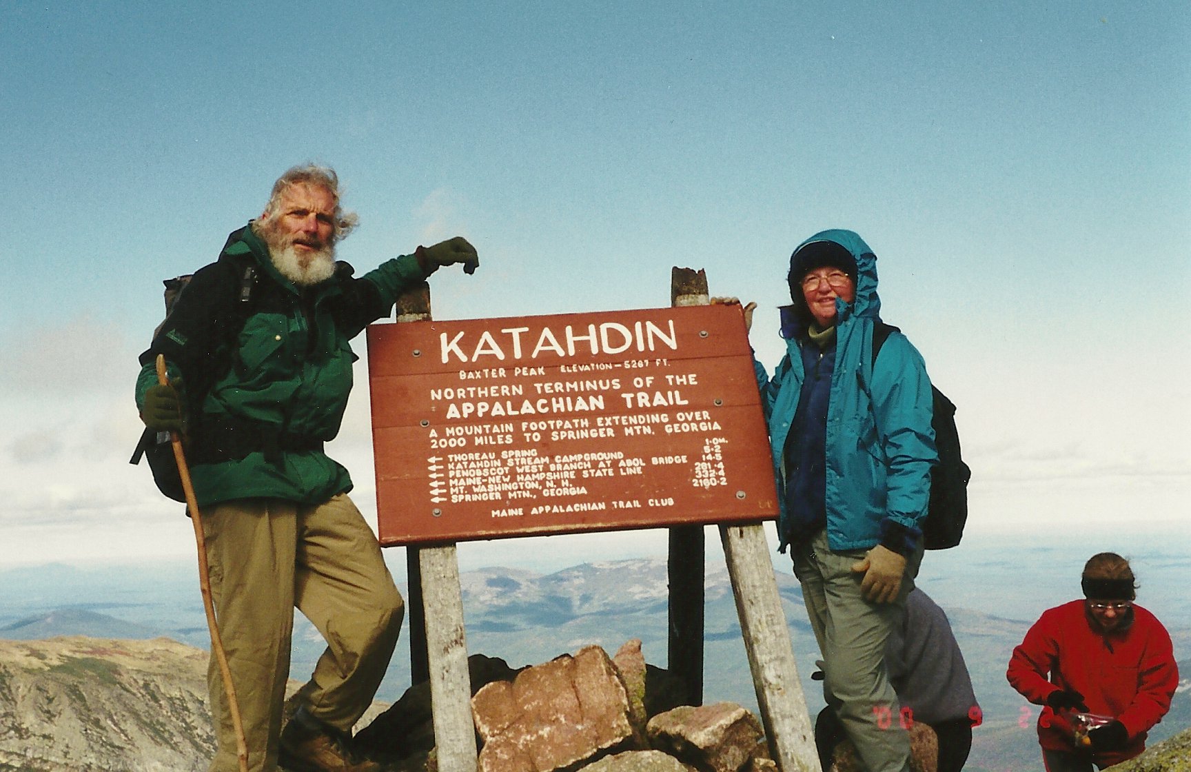
Sunday  9/24/00  16 miles/3957 Total.  246 Trail Days.  Katahdin Stream Campground, Baxter State Park to Roaring Brook Campground.

We took a zero day yesterday in order to rest.  I thought it wise since any other decision would have resulted in the mutiny of the support crew.  We got lots of chores accomplished.  Betty and Mae drove to Bangor to get some items that are not available locally.  It was an enjoyable day.

Today was a road hike within Baxter State park to connect the Appalachian Trail with the International Appalachian Trail( IAT).  The entire 16 miles was on remote gravel roads.  The trees are turning to their fall colors each day and it was a colorful hike.  The cool weather and scenic beauty with high mountains in the background made it a very enjoyable day.  Betty and Mae met me at Roaring Brook Campground at the end of the road.

“Mississippi Hiker” joined us for dinner, it was a pleasant ending to a good day.

Monday  9/25/00  19 miles/3976 Total.  247 Trail Days.  Roaring Brook Campground (Baxter State Park) to Trout Brook Crossing Picnic Area, (Baxter State Park).

Due to the long drive from our campsite to the starting point for the day, it was another 4AM rising.  The route today connects two trails which cross a remote northern area of Baxter State Park.  From Roaring Brook trailhead, the Russell Pond Trail is seven miles to an isolated, “hike in only” campground, then the Pogy Notch Trail is 9 miles on north to South Branch Pond trailhead.  Park officials advised us to plan two days for this 16.4 mile stretch.  Betty and Mae had me on the trail at 6:30AM to insure that I could make it in one day.  We did not need another night exercise.  Plus, we planned to celebrate our completion of the Appalachian Trail this evening with the Howells.

The Russell Pond Trail was not as easy to follow as the AT because it gets little use.  It is marked with blue blazes which seemed odd at first after hiking over 2000 miles following the familiar white blazes of the AT.  It was an easy hike, the most time consuming aspect was the repeated stops to photograph the morning sun on colorful trees, reflecting lakes and steep mountainsides.  At Wassataqueik Stream, I had to remove my boots to ford the icy water.  It was a little over knee deep and, fortunately, only about 30 feet wide.  Like most of the streams in this area, the bottom is covered with a jumble of smooth, slick rocks.  Crossing with bare feet is tedious and takes time, enough time to more than “cool your heels”.

At Russell Pond Campground I talked with a couple of campers, the only people I saw on the trail today.  One of the campers had a “Trail Crew” AT hat.  I asked which section of the AT was his responsibility.  He said it was the Hunt Trail up Katahdin Mountain to Baxter Peak.  I told him he should do something about all those boulders.  He laughed and said that they were planning several reroutes around the more difficult parts of the boulder climb.  Evidently, numerous accidents and the prolonged time to negotiate these areas has been a major concern for them.

The Pogy Notch Trail had more rocks and roots, plus more ups and downs.  I had lunch on the shore of Upper South Branch Pond; it was spectacular.  It was 2:30PM when I reached the trailhead.  I was early, so I started hiking out the gravel road that Betty would use to get into this area.  After a couple of miles I reached a road junction at Trout Brook and waited there for Betty since it would be possible for her to arrive from either direction.  She drove up without Mae on board.  Mae had brought her little Boston Terrier pup, Susannah, and could not enter the state park.  They hiked a couple of miles, taking lots of pictures of the autumn foliage.  We picked them up then hustled back to our RV site, about 70 miles, so we could clean up for our celebration dinner.

We met the Howells at the Terrace Hotel restaurant in Millinocket.  As we walked to our table, I was totally surprised to find a “hiker doll” that looked so much like me in my hiking gear that it was scary.  Betty had arranged to have Mae make this weeks, maybe months, ago.  It stands about 14 inches tall, has a walking stick and is complete, even to include a whistle around the neck and a map in the right shirt pocket.  The likeness must have been good because when Betty and I walked in the door, a waitress immediately said, “Your table is over this way” and led us to it.  She explained that she recognized me because she had seen the hiker doll.

Mae had also made a diarama depicting the hike.  Starting with Key West as the lowest point it traced the highlights of the route through Florida, the Appalachian Trail and on to Cape Gaspe’, Quebec.  It was three dimensional and had lots of partially hidden surprises: a bear in the woods, a moose, a Canadian maple leaf, rock walls, etc.  She included something from each state we passed through and the route that we still have in front of us.

We had a wonderful evening with great friends and good food!!

Tuesday 9/26/00  7 miles/3983 Total.  248 Trail Days.  Trout Brook Crossing Picnic Area (BSP) to Matagamon Gate of Baxter State Park.

Directly after breakfast Mae packed the last few things in her car and started the long journey south to Naples, FL.  She has been a viable part of our trip and we would have liked for her to stay for the Canadian portion.

Betty and I moved the RV north about 50 miles and parked it temporarily.  Then Betty took me to Trout Brook Crossing so I could finish hiking out of Baxter State Park.  Those last seven miles were a breeze.

We then returned to get the RV and drive north.  We intend to hike the mountainous portions in Canada first before winter storms and snow preclude hiking in those areas.  We will then return to hike the lower elevations from Maine north to Cape Gaspe’.  We drove until about 8PM and dry camped behind a gas station in Van Buren, Maine which is right on the Canadian border.

Betty:  There are a lot of things that we have to consider now, if we are going to complete the trail this year.  Baxter State Park closes on October 15th and sometimes earlier if the weather turns bad, which meant that we had to make sure “Swamp Eagle” had hiked out of Baxter State Park.  The Canadian Appalachian mountains will soon receive their first bad snowstorms, plus the Canadians close the trails not only for snow, but for moose hunting season and for Caribou breeding season, all of which occur in the October timeframe.  They have been known to make some exceptions for hikers, but not always.  The Caribou breeding regions seem to be the areas with least exception, so we need to head up to complete those sections before the trails are closed.  Once we complete all of these “areas of concern” we can return to Maine and proceed north with the hope of finishing sometime around mid November.

Wednesday  9/27/00  0 miles/3983 Total.  249 Trail Days.  Travel Day to Canada.

On the road before 6AM, in the heavy fog we missed the turn to the border crossing.  We had to unhitch the Honda to turn around.  The agent at Canadian customs quizzed Betty about items we might have on board: alcohol, firearms, mace, pepper spray, etc.  He then said he wanted a closer look and proceeded to go through closets and drawers in the RV.  Betty said she knew it was because she broke eye contact with him when he said, “firearms”.  Fortunately, we had sent our complete arsenal back with Mae to avoid just such complications.  We did declare a canister of pepper spray.  They confiscated it, then, after some debate with a supervisor, returned it.  Finally, we are heading north through New Brunswick on a little used, but paved road.  Miles and miles of timber and hills went by before we reached Matapedia, Quebec.

We parked in front of the Restigouche Motel and called Paul LaBlanc, our point of contact for this part of the IAT (International Appalachian Trail).  Soon he stopped by with some beautiful trail photos and a xeroxed map.  He said his son, David, had lots more info and better maps.  Paul had just left when David came home for lunch; he lives adjacent to the motel parking lot.  I recognized him from the trail pictures Paul had shown us.  David went to get his maps and then we had a long planning session as he deluged us with good, pertinent information.  B & B had left maps and information for us with David.  With all this information we should be in good shape.

Before leaving Matapedia, we went to see Pete Dube, who owns the Restigouche Motel and was a member of the first Board of Directors for the IAT.  Nimblewill Nomad had asked that I contact Pete.  It was time well spent.

Our plan was starting to take shape.  We would go first to the Parc de la Gasp*sie and hike the mountainous portion that will close in a few days due to the annual caribou migration.  Then we will hike the other portions of the IAT within the park.  Next, we will hike through two game reserves.  Moose hunting season starts this coming Saturday, so there may be some restrictions on our movement in the area.

It was late in the afternoon before we reached the mountain road to the park office.  Betty had information about an RV park and soon we were there talking with the owner Georges Beniot.  He recommended a little restaurant  that had the best home cooked meals in the area.  It was also the only place to eat in the area.  Nonetheless, Chez Polo was an excellent “choice”.  We had onion soup, fish and chips and fresh raspberry pie with ice cream and coffee – did I mention a couple of LaBatts to get everything started.  It was all good, but the onion soup and raspberry pie were extra special.  Whether by design or neglect, the service was much like the French technique.  Keep them waiting for each item and they will love it when it finally arrives.

It started raining about dark; hope this is not an indication of the weather we will have for the next few days.

Thursday  9/28/00  6 miles/3989 Total.  250 Trail Days.  Quebec Road 299, Parc de la Gaspesie Interpretation Center to Lac aux Americans Parking area.

This morning we drove north into the mountains to the Canadian National Park “Gaspesie”.  At the park’s Interpretive Centre (Visitor’s Center) we met Madeleine Soucy.  Fortunately, she spoke English and helped us work out a schedule to hike through the park and through Matane Reserve.  If we had been just one day later, we would not have had enough time to hike through the caribou areas before they are closed on 1 October at sunset.  In the Matane Reserve, we will be restricted by moose hunting season which starts on 11 October.  Madeleine called a colleague, Jean Pierre, who secured an agreement from the Matane Reserve to allow me to hike from 9AM to 4PM each day.  I must wear an orange vest and cannot remain overnight in the Reserve.  We think we can make this work.  Others have told us that they were not allowed in the Park nor in the Reserve and had to hike on roads to bypass these beautiful areas.

It was noon by the time we worked out the details.  We left the RV in the Interpretation Centre parking area and Betty put me on the SIA/IAT (Sentier International des Appalaches/International Appalachian Trail) at Quebec Road 299.  It was a steady climb, but only six miles to Lake to the Americans (Lac aux Americains) parking lot where Betty met me.  The SIA/IAT is marked using metal rectangles 2 inches wide and 5 inches tall.  This marker is painted white with a blue border and blue lettering.  It reads “SIA” across the top and “IAT” down the center.  Both letter groups use the same “I”.

The weather here is noticeably cooler.  It snowed at some of the higher elevations last night and the dusting was brilliant in the morning sun.  Even when I was hiking at mid-afternoon, snow still covered areas not in direct sunlight.

There were several recent moose tracks on and near the trail.  Earlier today we saw a porcupine that had been killed last night.  Tomorrow, I hope to see caribou.  I’ll be passing through an area that is home to the only caribou herd south of the Saint Lawrence Seaway.

Betty found a campsite right on the Seaway just outside the coastal town of Sainte-Anne-des-Monts (Saint Anne of the Mountains).  Because it is late in the year, we are the only ones in the campsite.  Our front bumper is about 20 feet from the shore.  We can sit inside the RV and look out through the windshield onto the seaway.  It’s a “cool” place.  The owners, Normand and Diane Lafreniere, invited us into their home for tea after dinner this evening.  A couple from France is staying in the Lafreniere’s Bed and Breakfast and also were there for tea.  We had an enjoyable, but somewhat strained evening with us trying to understand French.  Normand and Diane speak English and Normand translated for us when our meager French and gestures were inadequate.  It was a fun evening.

Friday  9/29/00  14 miles/4003 Total.  (54 on the IAT)  251 Trail Days.  Lac aux Americains parking area to La Galene, Quebec Rd 2. 

Another early start, it was an hours drive to the trailhead and Betty had me there a few minutes after 6AM.  The ground was still frosted and crunched with every step.  Normally, I hike in shorts, but after about 15 minutes I pulled on some insulated pants.  It was clear and beautiful as the sun peeped over the mountains.  Soon I was on top of Mont Xalibu (Mount Caribou) then down along a saddle to Te’tras Refuge.  This is a building with eight bunks, a table and most importantly, a wood burning stove.  I’m sure these refuges are a welcome sight at the end of a long cold day.

As the long ascent of Mont Jacques-Cartier began, the trail entered a long area of broken rocks about the size of basketballs and breadbaskets.  Most of the rocks had sharp corners and edges not yet smoothed by the elements over time.  This made footing precarious since most of the trail was covered with snow.  As I went up hill the weather went downhill.  That clear sky was soon a full cloud cover which made it colder almost immediately.  The wind steadily increased as the trail emerged from treeline.  Soon I was wearing a knit hat, gloves and a wind parka over an insulated jacket.  The wind was now blowing even harder and it was starting to snow, not snow flakes, but rather snow pellets.  Visibility was reduced to only a couple of hundred feet.  Fortunately, the trail was well marked with cairns as it switched its way up to the summit.  Now I have my hood drawn tightly over my knit cap, my gloved hands have found the warming pockets in the parka.  Snow bullets are blowing sideways and the cold wind is cutting through multiple layers of clothing.  The summit house is in site.  It is two stories with a stove on the first floor in an enclosed area and the second floor is an enclosed observation area.  Their indoor/outdoor thermometer shows the outside air temperature at minus 7 degrees centigrade (about 19 degrees Fahrenheit).  The wind was shown as 55 kilometers per hour (33 mph), no wonder it seemed chilly out there.  Mont Jacques-Cartier, the highest mountain in Quebec, was named after the famous explorer and cartographer.  Do you suppose Cartier is where the word cartographer originated?  Mont Jacques-Cartier stands 1268 meters high, which is about 4,298 feet.  I had lunch and made my way down the other side of the mountain toward the point that Betty would be meeting me.  Once below treeline the wind subsided, the temperature was warmer and clothes started coming off again.

Betty arrived at nearly the same time I did, she said we would stop to see Raymond as we went through the coastal village of Mont Sainte Pierre.  Even though not a hiker, Raymond has a bar, restaurant and motel at a strategic point on the IAT.  He keeps track of most IAT thru-hikers and we compared notes on those hikers we had seen recently.  I had read in the summit register that “Class 5”, Jon Leuschel, passed here on 18 September 2000, eleven days ago.  Of course, Raymond had talked with him.

Back at the RV, we had new neighbors in the campground.  Tom and Karen Ried, from Palo Alto, California, came over for a short visit.  They have been touring the Northwest and Canada for about three months.

We had a great dinner of poached salmon at Restaurant du Quai, a local restaurant.

Betty:  For those of you who may drive up here in your RV’s.  We are parked at “Camping du Rivage” in Sainte-Anne-des-Monts.  The sites are right on the St. Lawrence seaway.  They have electric (15amps).  There is a restroom facility, no showers.  They have a dump station and fresh water.  It is a beautiful area. Email: roseriva@globetrotter.net  I am on my way over to see if I can use their phone line to post this.  If it is posted, it will be with thanks to Normand and Diane.

Later – They do have a modem hookup.  In talking with Normand and Diane, they told me they will have the 15 amp power upgraded next year to 30 amps and also will have water installed at each site.  They are also planning to add a number of new sites.  In addition to the RV sites they have lodging in their house, “Gite La Villa des Roses”.

Saturday  9/30/00  17 miles/4020 Total.  252 Trail Days.   Lac Cascape’dia on Quebec Rd 11 to Le Gite du Mont Albert on Quebec 299.

“O-dark-thirty” and we are out on the backroads of the Gasp* peninsula in the rain.  Betty finds the trail crossing near  Lac Cascape’dia (Lake Cascapedia) and leaves me there in the rain, the sun wasn’t even up.  It is to be a 17 mile day over Mount Albert (Mont Albert), a mountain with an altitude.  And, most importantly, if we don’t complete the hike back to Le Gite du Mont Albert, we will have to wait until next summer.

As of sunset today, park officials close the areas we have hiked the last two days and that which we plan for today.  This large mountainous area is home to a small herd of wood caribou, the only herd remaining south of the St. Lawrence Seaway.  At one time, this herd was huge and, with other herds, ranged much of Southern Canada and northern United States.  It is estimated that only 200 caribou remain.  Consequently, there is a major effort to protect them.  The rut season starts in October, so those “in the know” have selected the first of October to close the area.

It rained early this morning and the trail is wet and muddy.  After a few minutes of slipping and sliding, I am wet and muddy.  About 8:30AM, I met Harry Feldman, a native of New York, now living in Australia and hiking here in Quebec to practice his French.  We exchanged information about the parts of the trail we had each hiked.  He corrected an error on my way which proved to be very helpful later in the day.

After several hours of wandering up and down through Fir and Yellow Birch, the trail climbed through a Fir and White Birch zone then on up through a Fir and Black Spruce area and finally onto the alpine tundra.  The massif that includes Mont Albert (Mount Albert) has a large relatively level alpine top.  This impressive area is above the tree line and the views across it are great.  It is an alpine tundra, much of it soaking with water just below the surface grasses.  Rocks are scattered everywhere and the wind is relentless.  Fortunately, it is much warmer today, so the wind is not as biting as yesterday.

On a slope about a half-mile across this barren mountain plateau, I spotted at least two, probably three and possibly five or six caribou.  For sure, two were moving about grazing, a third one looked to be in motion also, then there were some that looked like caribou, but with no apparent movement, I could not be sure.  I did get a picture, but the distance was so far that they will probably only be dots.

The trail is marked with sticks and poles and cairns, as it winds up, down and around with the contours of the land form.  This goes on for a wonderful couple of miles then the trail descends steeply down a massive rock valley.  Vertical rock walls line either side of this canyon.  Water from the tundra is pouring down a stream over rocks and high waterfalls.  Dripping water has created hundreds of huge icicles, some about two feet in diameter and maybe 20 feet long.  There are dozens of ice formations containing interconnected icicles.  The warm day is causing the ice to melt.  Several times I heard a loud crack that echoed through the canyon as large pieces of ice broke and fell.  One time the falling ice, broke off more ice as it fell, then caused some rocks to break away.  Even though it was a very small avalanche, the sound was awesome.

In and near the rocky stream bed are tall poles marking the winter cross-country ski trail.  These poles are about 15 feet tall and have reflectors on the top.

About five kilometers from the end of today’s hike, I came across Tom and Karen, our RV neighbors that we met last night.  They were out for a day hike in the vicinity of Mont Albert.  It had started to rain again and the trail was slick and muddy.

Betty extracted me at Quebec Road 299 and whisked me back to a cold beer and hot shower.

Sunday  10/1/00  16 miles/4036 Total.  253 Trail Days.  Quebec Rd 11 (near Le Huard Refuge) to Lac Cascape’dia.

It was a long drive on mountainous back roads to get to my starting point.  Along the way, a large bull moose was blocking the road.  What a huge, regal animal.  He climbed into the underbrush and stopped just inside the woodline.  He had joined a cow moose.  They sniffed and paced and did a little do-si-do dance with little concern that we were watching.  After a few minutes, they ambled deeper into the forest.  A great show to start the day.  “Good Morning, Canada”!

Almost immediately the trail climbed to Mont Arthur-Allen.  It was a clear day, and the visibility from the summit was very good.

Due to the rain during the past couple of days, it was easy to spot fresh tracks.  No people, lots of moose, a fox, and a bear had all left their mark.  Also, I saw what looked like large dog tracks, but no one was walking with it and dogs are not allowed in the park.  I’ll have to check to see if wolves frequent this remote part of the park.  Several times everyday, I have seen Spruce Grouse and today was no exception.  They are so unafraid of people it is a wonder any are left.

It was lunch on Mont Blizzard and a stop at Pic de l’Aube for the view, then on in to Lac Cascape’dia where Betty was waiting.

Betty:  This morning we enjoyed seeing the bull and cow moose, then this afternoon as I drove out to pick up Chuck, I was confronted with the fact that moose season has really begun.  I met two vehicles with dead moose heading back into town.  It made me sick to see them strapped to the vehicles knowing that only hours before they had been beautiful, live creatures, searching for their mates and falling prey to a hunter.

Monday  10/2/00  11 miles/4047 Total.  98 Total for IAT.  254 Trail Days.  Cap-Chat (Road #1) in Matane Reserve to Mount Logan.  We packed my large “Gregory” pack with items needed to overnight in the mountains.  Winter clothing, sleeping bag, etc. are more bulky and heavier so the small lightweight “Lowe Alpine” pack I have been using was retired for the moment.  Since we were not certain that I could stay in a refuge (shelter), I needed to carry a tent and mattress so I did not have to spend the night above treeline without any type of shelter.

We entered the Matane Reserve on a gravel road, Cap-Chat Road.  It was about 30 miles to the point where the IAT crosses Cap-Chat Road.  We had to purchase a six dollar entry permit and since it is now moose hunting season I needed to wear red or orange.

Immediately after Betty dropped me at the trail, it started climbing.  First it was past a beautiful and high waterfall, Chute Helene, then up more and more.  Next the trail descended several hundred feet to cross a stream, then back up over a ridge, up and down till mid-afternoon when it was up a very steep mountainside of mostly grass and mud.  This workout ended at the summit of Mont Collins, 1022 meters.  This does not appear to be very high, about 3,342 feet.  However, the base of most of the mountains is within a hundred feet or so of sea level and due to the northern latitude, timber line is about 2700 feet.  Anyway, it was a tough, time consuming climb.  Then down onto a saddle to go up Mont Matawees, down a ridge, across a stream and up Mont Fortin.  Down a long exposed ridgeline and finally up a long ridge that led to Mont Logan, 1128 meters.  The views from Mont Collins and afterward were awesome.  Much of the time it was nearly straight down, often on both sides of the trail.  It was an exhilarating hike.

Just prior to the summit of Mont Logan, I saw a small sign reading: “Point d’eau”.  It was later afternoon and I needed to get water before camping.  It was good to see this sign indicating a water source a few hundred meters away.  It was a little spring and I pumped three quarts through my filter.

Mont Logan is very isolated, there is an unmanned antennae site and an old shelter with a few bunks and a wood burning stove.  It was not the Hilton, but any shelter on a mountain will do.  I was wet from perspiration, tired and getting chilled in the howling wind.  It was after five and the door did not have a lock, it was home for the night.  The woodshed outback was filled with cut and split birch.  With a little birch bark for a starter and some splinters for kindling, I soon had a roaring fire.  The stove had a flat top and my cooking pot was ready for business.  The shelter, even though old, is well built and insulated.  It has lots of windows for good light, but all have storm windows covering the outside.

After a great meal of pasta and sundried tomatoes, I was on one of their bunks before it was totally dark.  It was soon obvious that I had over done the fire.  The wind was blowing at about 30 mph, but the temperature was probably only in the forties.  The door was on the lee side, so I propped it open to get some cool air and went to sleep.  About eleven PM, it cooled and I closed the door but did not restoke the fire.  It was a good starlit night.

Tuesday  10/3/00  13 miles/4060 Total.  111 on the IAT.  255 Trail Days.  Mont Logan, Quebec to LeHuard Refuge on Parc Road 11.   Up at first light and the wind is still blowing hard.  They have cables at each corner of this refuge to guy it down.  That is a sure sign that the wind can get really strong.  Still, now as the building shakes and quivers against the wind it’s comforting to know that we are anchored to the mountain.

After putting a little more wood on the coals that remained in the stove, I soon had heat to cook some ramen for breakfast.  With everything stuffed back in the pack, I was descending off Mont Logan.  Only a quarter of a mile from the refuge, I saw fresh bear tracks on the trail.  This possibility did not cross my mind as I propped the door open last night.

A few minutes later there were caribou tracks.  The primary locations for caribou are on Monts Jacques Cartier, Xalibu, and Albert.  Caribou tracks are cloven, but much more rounded than moose tracks, there was no doubt that it was caribou.  It was exciting to see tracks of an animal in an area other than its known range.  Later in the day, I spotted the tracks of a small cat, maybe a  lynx, I thought.  But, back in the RV I read that lynx are larger.  It might have been a bobcat.

By midmorning I was laboring up a slope when I heard something in front of me.  Then I saw caribou tracks that were coming toward me, but had skidded to a stop.  Realizing that the animal had sensed my approach and bolted from the trail, I stopped and looked closely.  Wow, about one hundred feet to my right was a male caribou with its large distinctive rack.  Slowly, I reached for my camera but as I lifted the cover, the sound of velcro separating was more than this guy would stand for, he disappeared into the undergrowth.

It was early when I arrived at LeHuard Refuge, but Betty was already there.  She was chatting with a photographer that was trying to call moose close enough to get good pictures.  He told us that an angry bull moose had been on the trail, just minutes before I arrived.  He was really concerned about one being that close because last night an angry bull moose had tried to ram his car.

Betty:  Well, he got my attention.  He told me when I’m driving at night and see a moose to turn out my lights because the lights really make them crazy and they will run right for the lights.  I really didn’t want to know that, well, maybe I did.  Anyway, now I don’t want to see any moose.

Wednesday  10/4/00  14 miles/4071 Total.  255 Trail Days.  Lac Matane Trailhead to Mont Blanc Refuge.  It was a 60 mile drive, one way, for Betty to get me to the trailhead at Lac Matane.  The trail ascended to a ridge overlooking the lake and followed the ridgeline north for a couple of miles.  Then, some ups and downs until the steep climb up Mount Pointu.  Down off this pinnacle and back up Mont Craggy, it was like a roller coaster.

While descending down to a saddle, I heard some grunting and saw a large bull moose walking slowly just inside the treeline about one hundred feet below me.  Then I saw a cow in front of him.  They had not sensed me and were moving slowly to a point that would cross the trail in front of me.  I really did not want to meet them when we all reached that point.  Carefully, I continued, but never saw them again.

Now, for the long, somewhat steep ascent up Mont Blanc.  All day, I had been watching the time.  Since I had not brought a tent, I really wanted to reach the refuge on Mont Blanc before nightfall.  The climb seemed to take more time than it should and the sun was low in the west.

With about 30 minutes of daylight remaining, I reached the summit and the old shelter.  The building was about 10 feet by 15 feet and contained two sets of bunkbeds, a table, two chairs and a wood cook stove.  Unlike other shelters that had a square wood burning stove, this one had a true wood burning cook stove, complete with an oven and places for five large pots on the top.

It was cold and windy and there was not a large supply of firewood.  A few branches and dead fall had been placed behind the stove.  To conserve firewood, I built a fire in the small firebox and soon was cooking noodles followed by grits.  I put too much water in the grits and had the best grit soup I have ever tasted.

It was a cold night, probably in the mid-twenties.  With so little firewood I did not try to keep a fire going through the night.  Too bad, because it would have felt good.  As it was, I used all the tricks in my bag to keep warm: wear a knit cap, eat high fat snacks during the night, wear wool socks, etc.

Thursday  10/5/00  13 miles/4084 Total.  256 Trail Days.  Mont Blanc Refuge to Cap Chat Road at Mont Nicole-Albert.  Another little fire in the morning heated some ramen for breakfast.  It had snowed about an inch during the night so I dressed appropriately: long pants, gaiters, water repellant parka and gloves.  Before leaving the refuge I signed their register.  A lot of hikers had logged in during the summer but no one recently.  Jon Leuschel, “Class V”, had made the last entry on 12 September 2000, nearly three weeks prior to my visit.  Betty and I first met Jon in White Springs, Florida much earlier in our respective trips.

As the trail started up Mont Nicole-Albert, I saw a cow moose standing on the trail 200 feet ahead of me, then I saw a large bull with a huge rack, near her.  Both were watching me.  They grunted and after a couple of minutes, wandered off to my left.  Only seconds later, a young bull enters from my right.  He snorts and grunts and walks toward me.  My yelling and hat waving has no effect of him.  He stops at about 25 feet, then walks off to the left.  After a pause he circles and approaches again to within about 25 feet, then wanders off in the woods.

The miles seemed to go by fast and at 2:30 PM I was on the summit of Mont Nicole-Albert, about 3000 feet.  The west side of this mountain is a sheer cliff dropping nearly 2800 feet to a remote road below.  Betty was meeting me there.  On the off chance that she might be early, I tried calling her on the little walkie-talkies that Harold Howell, “Mississippi Hiker” had loaned us.  Betty was there.  I told her I would be down in a little over 30 minutes.  Not so, two hours later I was still descending very steep trail alongside high, but beautiful, waterfalls.  This went on and on, a treacherous, but awesome trail.  At many places the trail had drop-offs of several hundred feet.  The roar of the waterfall blocked other sounds at times.


Finally, I linked up with Betty and hiked the one mile road walk to the point on Cap Chat Road that I had departed three days ago.

Betty:  It occurred to me as I was typing this, it might be a little confusing as to why Chuck is hiking into places he’s already hiked out of.  So, here’s the explanation.  Chuck wants to hike the whole trail going north, but he had to get certain areas hiked before they closed and it seems the areas that were the highest and closing the first were the furthest along the trail.  There were two ways he could take care of these.  He could start at that furthest point and hike south, or if he wants to always hike north – then we figure out what section he is going to hike, I drive him to its southern point and he hikes north.  That is the way we are doing it, and it’s working very well.

Friday  10/6/00  17 miles/4101 Total.  156 miles on the IAT.  257 Trail Days.  John Entrance to the Matane Reserve to Lac Matane Trailhead.  We said goodbye to our new friends, Diane and Normand Lafreniere, who own the campground and a bed and breakfast.  We have been here six days, over twice as long as our normal stay.  The plan is to move the RV back to the west and south then look for a place to park it while I hike the western end of the Matane Reserve.

This Matane Reserve entrance checkpoint is staffed by Georgette LeVeque, a very pleasant and helpful lady, who speaks no English.  Nimblewill Nomad spoke of her willingness to help when he passed through here last July.  Because the campground portion of their operation is officially closed, she called her supervisor, Robin Plante, for an exception.  Robin said it would be fine and that he would drive to our location to help get us set up.  The water has been shut off and drained for the winter, but we do have electricity.  Power for the small ceramic heater provides more even and comfortable heat than having our propane furnace kick on and off during both day and night.

I hiked directly from the RV along a gravel road that leads deep into the Reserve.  It was an easy roadwalk and I made the 17 miles in just over four hours.  Mountain trails have taken over three times that long to go the same distance.  Betty met me at Lac Matane Trailhead.  This is the same point that I departed from two days ago on my way to Mont Blanc.

It was starting to rain as we made our way back to the campsite.  Along the way we saw a bull moose and a cow beside the road.  It was nearly dark as we watched them watch us.  Then they drifted into the shadows.

Betty:  We are really enjoying Quebec.  Diane and Normand at Camping du Rivage, were just wonderful to us and now here at the Reserve we have been treated very kindly.  We are looking forward to returning on a leisurely visit sometime in the future.

Saturday  10/7/00  25 miles/4126 Total.  258 Trail Days.  Amqui to John Entrance to Matane Reserve.  It rained most of the night, but by morning was only misting.  Betty drove me south to the town of Amqui so I could hike back north to our campsite at the entrance to the Matane Reserve.  Much of the route that I would hike through was covered with one or two inches of snow.  After putting me on

my way in Amqui, Betty found a place to have the oil changed in the Honda CRV.  Also, she had the antifreeze checked (-37 degrees) and had new windshield wipers installed.  Before leaving Amqui she stocked up on groceries.  The small towns we pass through have only had depanneur (convenience stores).

My hike was a 25 mile roadwalk, the kilometers clicked by and soon I was at a depanneur buying some sandwiches for lunch.  Betty knew this was about where I would be for lunch and she stopped on her way back.  We had a snack in the car; it was warm.

After arriving at the campground, I talked with the agent at the game check point to see if the water here was potable.  He said no, but he would allow us to run a hose into their kitchen to get drinkable water to fill our tank.  We’re the only ones in the campground and since the campground water has been shut off, we probably got special consideration.

The agent, Rejean Desgens, told me that hunters here have a 95% success rate and that they will take 200 moose this season.  They are permitted to take bulls, cows and young adults, but not calves.  He said they estimate that there are five thousand moose on this huge Reserve.  The IAT has been almost solid with moose tracks.  This land and 17 other reserves were set aside in the 1960s.  At that time there were only about 500 moose, but with proper management the population has steadily increased.  During the few days that we have been in the Reserve we have seen over a dozen moose.  Monsieur Desgens said the timber harvesting, so prevalent in the Reserve, helps the moose population.  Moose feed on the grasses, weeds and young tree sprouts that flourish in the sun after an area has been cut.  Also, moose like the tender seedlings used in reforestation.  I told Betty all of this, but it did little to help her accept the killing of these special animals.

Betty:  If they can now shoot cows, what happens to that cow’s calf?  I do understand that there has always been hunting and probably always will be.  I even intellectually will concede that overpopulation makes for weaker animals and that well managed hunting areas seem to  have healthier animals.  There is just something so sad and sickening about seeing these large, regal animals “spread eagled” on top of some trailer going down the road.  Their dignity is gone, not to mention their life.  I have to say there are some hunters who cover the animal up and treat them with some dignity, but most want to show them off.  Anyway, it’s not something we’re going to change, so enough said.

Sunday  10/8/00  22 miles/4148 Total.  203 miles on the IAT.  259 Trail Days.  St Marguerite to Amqui.  We topped off our fresh water tank and said good-bye to Rejean as we prepared to move the RV to Amqui.  Rejean gave us a copy of the weather dispatch they had just received; rain.  Our stay, here in the middle of no-place, has been very comfortable and informative.  Robin and his “band of agents” have made us feel very welcome.

After positioning the RV, in the parking lot of an old motel that had nearly burned to the ground years ago, Betty drove me the 22 miles to St. Marguerite so I could hike back to the RV in Amqui.  Our procedure seems a bit complicated ever since we leaped forward to hike the portions of the IAT that are in the Canadian Mountains.  Having completed the highest parts of the trail in Quebec, we are working our way south but I am always hiking north.  We want to do as much of the trail in this northern area as we can before the weather gets so cold that the tanks and pipes in the RV will freeze.  The plan is to keep moving south, but hiking north, toward New Brunswick and Maine.  When it gets too cold for the RV, we will drain the tanks and park it, then drive the Honda back to hike the remaining portions of trail and finally to hike the 10 day stretch from La Galene (the most northerly point I have hiked thus far) to Cape (Cap) Gaspe’.

Today the route skirts the southern boundary of the Duniere Reserve and the Matane Reserve.  We pass through the center of Causapscal, a quaint old village with large beautiful churches.  Betty read, in Nomad’s journal, about the Auberge La Coulee Douce (an inn to pass sweet hours).  While I was hiking in the snow and later rain, she located this Inn and made reservations for dinner.

Upon reaching the RV, I was cold and wet.  After a hot shower and a short drive we were enjoying a wonderful evening at La Coulee Douce.  It was much like the meals we have had at little restaurants and inns in France.  A mostly set menu with multi courses was served in a very relaxed atmosphere.  Enjoying great food, made even better with good wine, it was hard to believe that just two hours ago I was on the trail and soaking wet.  “La Coulee Douce”.

Monday 10/9/00   11 miles/4159 Total.  260 Trail Days.  Matapedia to St. Andre de Restigouche.

We moved the RV about 60 miles south to the town of Matapedia.  From Matapedia, I will hike north today to St. Andre de Restigouche and then will have a two day stretch from St. Andre de Restigouche to St. Marguerite.

The trail goes through the middle of Matapedia then climbs a steep hill overlooking the town.  The colorful leaves are falling now and in some places the trail is covered with a new blanket.  At times it is more difficult to follow the trail than it is without the leaves.  The trail twists and turns over hills and through valleys finally arriving at the little village of St. Andre de Restigouche.  It then follows a road north for 2 miles to a trailhead.  From the trailhead it is a two day hike to St. Marguerite.  Betty met me at St. Andre and Levi (our Schnauzer) joined me on the hike.

We returned to the Restigouche Hotel parking lot next to the home of David LaBlanc, Sally and their daughter, India.  They all joined us in the RV for some snacks.  Later, their friend, Bruno, arrived and we had many good stories about: the trail, moose, bear, the mountains and winters in Quebec.  Both David and Bruno are guides in this wild land.  Bruno also works as a skidder with a timber company during the winter.  David has a canoe livery business and is expanding it to include sled dogs.  In the winter he works as a biologist.  He and Bruno are now training the dogs to pull cross country skiers.  These guys also are responsible for building and maintaining one of the most rugged sections of the IAT.  David is planning to build a hostel adjacent to his canoe operation.  These guys love this great remote country and manage to spend as much time as possible outside in it.  Sally and David are passing this outdoor spirit along to India.  One cold morning we met Sally taking India for a two mile walk.

Tuesday  10/10/00  20 miles/4179 Total.  261 Trail Days.  5 miles North of Glenwood, New Brunswick on Rd. 17 to Matapedia , Quebec.  It rained all night and was cold and raining as we drove out this morning.  We decided to delay the overnight hike to St. Marguerite until better weather, so Betty took me 20 miles south and dropped me.  Sometimes I wonder if she really wants me to find my way home.  Today might have been one of those times.  After putting me on my way she drove on to look for a campsite.  As she gained elevation the rain turned to snow and soon she was in a heavy snowfall that would last all day and into the night.  She located Kedgewick Forestry Museum and Campsite, all of which closed sometime in September.  After checking for other places that might be open, she came back and convinced the caretaker to allow us to stay for a few nights.  He told her that the water had been cut off to prevent pipes from freezing but we could have electricity.

 Meanwhile, I am hiking north to Matapedia.  Soon I was hiking along the Restigouche River, This wide, shallow stream is known throughout the angling world for its great salmon fishing.  A local resident told me that many of the USA’s rich and famous have come here on a regular basis: Bing Crosby, Norman Schwartzkoph, and many corporate executives.  It is a picturesque river.

Once we were all back in Matapedia, we moved the RV almost 50 miles south to Kedgwick.  Betty was back in the same mountainous snowfall for the third time today.  It was dark when we arrived and it was still snowing.  Unfortunately, they had left the dump station padlocked and the parking site the caretaker suggested had an electrical breaker box, but no electricity.  We picked another site that did have power and by 8:30PM we were finally “home”.  During the day, Betty had purchased two “trouble-light” cord sets.  We placed one in each basement compartment that had a wastewater storage tank and underfloor plumbing.  Initial readings show the temperature to be almost ten degrees warmer with the lights.

After a great meal of steaming hot pasta, a garden salad, fresh French bread, and wonderful French wine, life again looks somewhat bearable.  Just like AA; “one day at a time”.

Betty:  I admit I have a low tolerance for problems and I usually error on the side of caution, so I have wanted to take the RV back to Maine to get it winterized before the tanks freeze.  Once I had dropped Chuck off and was headed south to try to find a campsite, already knowing that New Brunswick campsites have shut down for the season,  I was not happy to see the snow.  I thought about crying, but didn’t think it would serve any purpose, so I forged ahead, talked a lot to God about the weather, tanks, places to stay, etc.  We are in a precarious predicament.  At some point we will have to spend a day to take the RV to Maine.  The roads here are narrow and steep, so I am not driving it.  We already know of a place that will do the winterizing for us and we know of a place we can store it, but of course, this means a day or two off the trail for Chuck and he is also in a race with the weather.  So, right now we are trying to work our way south and with every couple days we are closer to Maine.  We also need to keep up with the weather forecast (which seems to be a problem) so he can do the high areas and the overnights when the weather is at its best.  So life goes on and we do our best.

Wednesday  10/11/00  27 miles/4206 Total/261 on the IAT.  262 Trail Days.  Kedgwick, NB to 5 miles north of Glenwood, NB.

At first light, an inch or two of snow covered the ground, trees and our vehicles, plus it was still snowing.  After we had breakfast, I departed north on NB Road 17.  It continued snowing until late morning.

Somewhere along this road, the IAT should depart to the northwest.  The New Brunswick Trail has two trailheads, but I must have missed the IAT intersection.  Yesterday I missed it also, but was pleasantly surprised with a beautiful hike along the Restigouche River.  Today the terrain consists of high rolling forests.  The predominate deciduous trees are maple and birch.  Evergreens here are fir and spruce.

We have heard that many, if not most, hikers have difficulty following the trail in this area.  Some have had to bushwack their way cross country to a road.  This is a very strenuous and time consuming way to hike.  For now, I am content to be making good mileage on a road rather than beating the bush.

Betty met me at our planned location and we returned to the Forestry Campground where we are the only campers.

Betty:  This campground, Kedgwick Forestry Museum and Campground, is beautiful.  They have wonderful sites.  In season, the sites have electricity.  They have very clean bathhouses, which they went ahead and shut down when I said we would just use our RV.  Jerry Perreault is the manager and has been very kind to let us stay even though they are closed.  We are the only site in the campground that has electricity and he has left the dump station unlocked for us to use, plus we can fill our water tanks at the office building.  We are very fortunate and thank him for his generous and kind support.

Thursday  – We will be staying at the campground until Saturday when we will leave for Maine.  This campground is right on the IAT, for those of you interested in hiking the IAT.  There are also lots of other trails in the area and canoeing possibilities.  Their email: museforest@hotmail.com    The weather has given us a little break and Chuck left this morning to do the only overnighter he had left.  I drove him to St. Andre de Restigouche where he started his hike to St. Marguerite.  I will pick him up in St. Marguerite tomorrow.  After dropping him at his starting point, I drove into Campbellton, New Brunswick to do laundry and buy groceries.  Campbellton is one of the larger towns in the area and has a good supply of services.  It’s about 56 km north of Kedgwick.  When I got back to the campground I talked to Jerry about using the phone line and I believe tomorrow I will have a chance to update the website.  Hope so.  He and Raymond are busy closing everything up in the park.  They have picked up all the trash containers and picnic tables from all the sites and have stored them away for the winter.

If you get to read this, it will be with our Thanks to Jerry and Raymond.

Well, Jerry did let me use the phone line and I was able to check messages, but for some reason my update wouldn’t go through.  So I will try again at another time.  It was great to have the opportunity to check messages.

Thursday  10/12/00  13 miles/4219 Total.  263 Trail Days.  St. Andre de Restigouche to Assemetquagan River.  The weather for the next few days is forecast to be warmer and dry.  We will take advantage of the better weather to hike the two day stretch from St. Andre to St. Marguerite.  We had put this overnight portion in Quebec on hold until the snow and freezing weather moderated.

It was early when we departed the RV in Kedgwick, NB.  Betty drove me the 60 miles back to St. Andre de Restigouche, Quebec.

At 8:55AM, I was on the trail for a two day hike through some beautiful Canadian wilderness to St. Marguerite, Quebec.  The morning was cold, but without precipitation.  About two inches of crusted snow crunched with each step.  The snow and a thick blanket of recently fallen leaves made it a challenge to stay on the trail.  The IAT in this area has only sparse markings and they take many forms.  Sometimes the standard 2″ by 5″ blue and white SIA/IAT plaques are used; at times blue and white plastic strips are tacked on trees; orange, pink or blue tape is occasionally tied to bushes and other times white, blue or orange spray paint is on tree trunks.  Often there are no visible marks of any sort for nearly a mile.  After over 4000 miles of following all sorts of trails, it is generally easy to follow a trail, even unmarked.  However, the IAT is a relatively new trail and gets only infrequent use.  Anyway, it must have been adequately marked because in spite of the snow and leaves, I was able to follow it.  Progress was a little slower than usual and there was a lot of uncertainty.

Fresh moose tracks were common, also some deer tracks, plus there was a lot of older bear scat, but no fresh bear tracks.  Grouse are seen every mile or so in the mountains.  The steep hills and valleys of this rugged country are better suited to these hearty wild creatures than to humans.

Late in the afternoon I reached the Assemetquagan River.  Previously, I had been told that there were at least two and possibly four rivers to ford.  The Assemetquagan at this point is shallow, about 18″, but wide, maybe 200 feet.  I carry Teva, strap on sandals, to wear when fording.  The recent cold weather and now melting snow made for a cool crossing.

It was 5:30PM and I made camp on the far shore.  Rice with broccoli was hot and good.

Friday  10/13/00  11 miles/4230 Total.  285 on IAT.  264 Trail Days.  Assemetquagan River to St. Marguerite, Quebec.  Last night I slipped into a sleeping bag at 7PM and did not crawl out of it until 6AM this morning.  It was a good night’s sleep.  A cold breakfast of fruit bars and water, a quick pack job and I was on my way.  It was a steep climb to a ridge with a good view of this expansive, rolling wilderness.  At higher elevations nearly all the leaves that are going to fall are now on the ground.  An exception is the European Larch.  This cone bearing tree with long soft needles looks like an evergreen but is actually deciduous.  Its normally light green needles have now turned to a bright yellow and stand out brightly in the midst of the aspen, black ash, maple and birch standing bare like skeletons, and the very green fir and spruce.  Venetian turpentine, a folk medicine that we often used to “doctor” horses, is made from European Larch.

Another ford, short but cold, and two “rock hops” across streams then past a shelter that was about 60% complete and up a steep long hill that led to a ridge and the final stretch for the day.

Betty was two hours early and had just arrived to drive us the 91 miles back to the RV campsite in Kedgwick, NB.

Saturday  10/14/00  0 miles/4230 Total. 285 IAT. 265 Trail Days.  Zero mile day – Traveled back to Maine.

Betty:  Saturday 10/14/00.  Today was a zero day for Chuck.  We moved the RV to Maine and Chuck will start hiking tomorrow in Maine and hike the sections of the trail that he hasn’t already completed.  After breakfast this morning, we dumped our tanks and proceeded south from Kedgwick, NB to Maine.  We arrived in Houlton, ME in the early afternoon.  The IAT comes through Houlton and is about a three day hike from the Matagamon Gate at Baxter State Park, where Chuck left off on the 26th of September.  We arrived here to find beautifully moderate temperatures and a wonderful campground.  We are currently camped in “My Brother’s Place” with full hookups and nice level grassy sites.  The office has a modem hookup and I will go over tomorrow to try it out. 

This is one of those rare days when we have some spare time.  Once settled in, we decided to go out to dinner and to a movie.  We drove around town, found a movie theater that had a movie we could easily pass up and decided to rent a movie and eat at home.  Well, we rented two movies and ate at home and it was wonderful.  What a great relaxing time.

We believe the weather is to remain above freezing for the next few days.  We are hoping to stay in the RV until Chuck has hiked to Houlton, then I will drive the RV south to Medway where it will be winterized and stored, while Chuck continues his hike north.  Say a prayer for us.

Posted in International Appalachian Trail, The Hike | Leave a comment

Appalachian Trail – 9/16/00 – 9/22/00 Little Wilson Falls, ME to Mt. Katahdin, Baxter State Park, ME

Saturday  9/16/00  23 miles/3832 Total.  238 Trail Days.  Little Wilson Falls to Katahdin Iron Works Road.  Betty drove us the 50 miles plus to our drop off point, then “Mississippi Hiker” and I had a mile hike on a connector trail to reach the AT.  Of course, the extra mile does not count in our miles hiked for the day because it is not on the AT.

Within an hour after intersecting the AT, we had to ford Big Wilson Stream.  It was a little over knee deep and about one hundred feet wide.  The roar of the rapids added to the drama.  “MH” was wearing low cut hiking boots that were still wet from yesterday’s rain.  He removed his socks and wore the already wet boots to cross.  I was wearing dry leather boots and I hoped to keep them dry so I slung the boots over my shoulder and crossed barefoot.  The water was chilly and swift, but the crossing was uneventful.  Next, we had a long climb up the Barren Chairback Range.  We crossed several peaks on this range so the hiking was mostly up and down.

We knew that 24 miles was cutting the available daylight pretty close; sunset is about 6:45PM.  We hiked fast all day trying to reach our rendezvous point before dark.  It was 6:50PM when we saw that beautiful, mud covered diesel pick-up truck and Wayne waiting to whisk us away to civilization, such as it is here in the north country.

Betty:  After the guys showered, we all headed into Milo for pizza.  Tomorrow, Sunday, we will move the RV’s forward to Jo Mary Lake Campground.  It’s between Milo and Millinocket.  It’s on land that belongs to one of the paper companies.  Because the roads are owned by the paper companies in this area, you have to pay to use them, and it’s $7 per person per day.  However, if you camp in the campground the cost is figured into the campground fee.  For us it works out better since we will use their roads for three days.  We will be camped right on the lake.  Nice.  We will move to Katahdin Shadows Campground in Medway on the 20th.

Sunday 9/17/00 21 miles/3853 Total.  239 Trail Days. Katahdin Iron Works Rd to Crawford Pond on Kokadjo Road.  Wayne had “MH” and me on the trail by 6:30AM.  Our first order of business was to ford the West Branch Pleasant River.  Today, I had my Teva Sandals and it was an easy crossing.  Then it was a long steady climb up White Cap Mountain (3654 ft).  It was eleven miles and six hours before we reached the summit.  On top, the wind was about 25 mph and the temperature 35 degrees with a cloudy mist; we did not tarry.

During the day we saw several (maybe six) ruffed grouse and one spruce grouse.  On the drive to the trailhead this morning we saw a cow moose.  It ran down the road in front of us for a hundred feet or so before moving into the bush.  Moose sign is all along the trail.

We arrived at our meeting point early and Betty drove up just a few minutes later.

Monday  9/18/00  7 miles/3860 Total.  240 Trail Days.  Crawford Pond to Jo Mary Road.

What a great day.  The sun was shining on Maine today.  Wayne took Betty “Honeycomb”, “Virginia Bluebird”, “Mississippi Hiker” and me to the trailhead.  It was a beautiful hike along Cooper Brook, easy trail, easy pace.  We stopped at Cooper Brook Falls Lean-to for a short break.  It is interesting to read the trail register and check on the progress of other hikers.

Wayne was waiting as we all arrived at Jo Mary Road (Jo Mary was an Indian who lived in this area).

My sister, Mae, arrived at the RV park late in the afternoon.  We had some great tasting 15 bean soup that Wayne prepared, then we all sat around a campfire on the lakeshore.  The large land mass of Katahdin stood proudly beyond the far shore of the lake.  It was good to have Mae “Crabby Trails” back on the trail with us.

Betty:  Originally, Mae and I had planned our meeting point and we were going to move the RV to Medway on the 17th.  Mae’s plans then changed, and in the meantime we found the campground at Jo Mary Lake.  When Mae headed to Maine from Indiana, I had not updated her on where we were.  I called Indiana and found she was already on her way.  So, I called the RV park in Medway (Katahdin Shadows) and explained the situation.  They said they would give her the message and tell her where we were.  Today, since our hike was a short one, we were in early and I figured Mae would be arriving mid to late afternoon.  I needed some groceries and knew the town was in a cell phone friendly area, so headed into town.  I was holding the phone up to the window as I was driving in order to pick up a signal and it rang.  So, I said “Hi Mae”.  It was, and we met at the store.  It all worked out fine.  We’re happy to have her back here with us once again.

Tuesday 9/19/00  20 miles/3880 Total.  241 Trail Days.  Jo Mary Rd to Nesuntabunt Mtn. Road.

Betty and Mae drove “MH” and me to the trailhead.  It was a flat, fast hike to our lunch stop at Nahmakanta Lake.  It was here that we would meet any of the others in our group that wanted to hike the remaining 5.5 miles.

While there eating lunch, “Mousetrap”, “Welches”, “Moses” and “Magnum” arrived.  After a short break, they moved onward.  Betty and Mae arrived shortly afterword.  They hiked with us the latter half of the day.  It was a good hike by Wadleigh Stream Shelter and up Nesuntabunt Mountain.  Betty and Mae paced themselves well, we took a break at the summit.

Wayne and Mary were waiting for us at the road crossing.  We were all glad to see them.  It was another great day on the trail.

Betty:  The mushrooms, mosses and lichens along parts of this trail were incredible.  Some of the mushrooms were as big as dinner plates.  A beautiful day and a wonderful hike.

Wednesday  9/20/00   20 miles/3900 Total.  242 Trail Days. Nesuntabunt Mtn Road to Abol Bridge.

 It was a foggy morning and the temperature was warmer than usual.  Betty and Mae drove us the 21 miles through some of Maine’s most remote roads to the start point.

“Mississippi Hiker” set a brisk pace as we moved alongside Rainbow Stream then Rainbow Lake.  The view of Katahdin from Rainbow Ridge was inspiring.  It is strange to think that in just two hiking days I will summit.  “MH” will wait until the 28th of September when his wife and son will arrive.

About four miles from our destination for the day, we stopped at Hurd Brook Lean-to.  This is the last trail shelter on the Appalachian Trail for northbounders.  “Moses” was there reflecting and making notes in his personal journal.  All the hikers we have talked with recently are beginning to experience the bittersweet feelings of completing a long hard hike and knowing that this great event is about to end.  Many have developed the strongest friendships of their lives.  Moses hiked with us to the Abol Bridge.  Along the way a sign indicated that we were leaving the One Hundred Mile Wilderness.  The Abol Bridge crosses the West Branch Penobscot River.  A small store near the bridge had cold beer and we relaxed at some outdoor picnic tables with “Welches” and others.  Wayne and Mary arrived and took us back to our new RV Park in Medway.

Betty: After driving “Swamp Eagle” and “Mississippi Hiker” to the trail, Mae and I started getting the RV ready for the move.  We departed Jo Mary Lake around 10:30 AM and moved to Katahdin Shadows RV Park in Medway.

Thursday 9/21/00  10 miles/3931 Total.  243 Trail Days.  Abol Bridge to Katahdin Stream Campground.  Wayne drove “MH”, “Virginia Bluebird” and me to the start point at Abol Bridge.  It was an overcast day with the prediction of rain.  The trail entered Baxter State Park and was very scenic, first along the Penobscot River, then along Nesowadnehunk Stream.

At Daicey Pond Campground, “Virginia Bluebird” found the small lodge that her Great Aunt and Great Uncle visited annually for over 20 years.  “VB” had a photograph, taken in 1964, of the lodge.  It is now called the Camp Library, but is definitely the same building.  It is a rustic one room building with a small porch overlooking the lake.  Baxter State Park has no electricity, so the building has gas lights and a wood burning stove.  Old photos and bookshelves line the walls.  Most of the books are over 30 years old, some over 50 years.

While at Daicey Pond Campground we were required to register for our hike up Katahdin, it was a pleasure.  Less than three miles later, Betty and Mae met us at Katahdin Stream Campground.

Later, the Howells met us at the Appalachian Cafe in Millinocket for dinner.  Several other hikers were there.  Excitement was in the air.

Betty:  Baxter State Park has several campgrounds, however they don’t take RV’s the size of ours and they don’t allow pets, so that is why we didn’t stay at the park.

Chuck and Betty on Katahdin

Friday  9/22/00  11 miles/3941 Total.  2167 on the Appalachian Trail.  244 Trail Days. Katahdin Stream Campground to Baxter Peak (Katahdin) and back to Katahdin Stream Campground.  

Up at 4:30AM, a quick breakfast then a 36 miles drive to Baxter State Park.  The park opens at 6AM and by 6:15 we have our permit and the weather briefing required to climb to Baxter Peak on Katahdin (elevation 5267 feet).  We are told there would be no precipitation and that the cloud cover should clear, the good news.  We are also told to expect winds above treeline to reach 50 mph and temperatures as low as 30 degrees.  My chart shows this to be a windchill of minus 2 degrees.  We all had warm clothes and windbreakers, but 50 mph is still a little much.

Our plan was that Mae, Betty and I would get an early start, hike up Katahdin Mountain to Baxter Peak, then hike back down the same trail to our vehicle.  The Appalachian Trail ends at Katahdin.  I plan to hike back down the mountain then walk along a gravel road that goes around the east side of Katahdin’s base then north a day or so to exit Baxter State Park.

We logged in on the trial register at 6:50AM and started the long hike up this famed Mountain, a 4,000 foot climb.  “Mousetrap”, “Magnum” and “Welches” were also summiting today, they hiked with us a few minutes then moved on ahead of us.  The trail was rocky with lots of roots and graded upward.  We crossed Katahdin Stream on a footbridge near the falls and the trail became steeper with larger rocks.  Soon the climb was even steeper and often over boulders.  Our progress was slow.  At about 3400 feet we were above treeline and the wind was about 20 mph.  The steep climb up to Hunt Spur was through a large nearly vertical boulder field.  Climbing over, around and between these huge boulders and rocks was time consuming and tiring.  Finally, we made it over Hunt Spur and along a ridge then it was up through another large, vertical boulder area.  This steep climb led up to another spur called  The Gateway.  The exposure on all these areas was considerable with sharp drops of hundreds of feet.

During the climb up to Hunt Spur, we were all moving slowly and I noticed that Mae was having difficulty moving her legs especially on long or high stretches and reaches.  She and Betty suggested that they return to the parking area so that I could make better time.  But when I said I would go with them, they elected to press on.  About half way on the climb up to The Gateway, Betty was leading and did not know that Mae stopped for a break.  I waited with Mae and she said she was not going any farther.  She wanted to rest there in a protected nook tucked in the rocks while Betty and I continued to the summit.  Her little site was right alongside the trail and she was wearing warm clothes under her windbreaker.  At this point, I knew that she needed some time to recuperate before heading back down.  She promised not to try to go back down until we returned and I went up to catch Betty.

It was slow going with strong wind and exposed areas, but we finally crossed The Gateway and were on the Table Land.  This is a huge, flatter alpine area strewn with smaller rocks.  We could see the trail winding up through the Table Land and then more steeply up to the ridge leading to Baxter Peak.  The going here was much easier and we were soon standing at the summit.  This was a momentous occasion; it was the end of the 2167 mile Appalachian Trial which started at Springer Mountain, Georgia.  The sky was only partly cloudy and we had a beautiful 360 degree view.  The wind was less than 25 mph and the temperature in the thirties, much more comfortable than predicted.  Icicles were hanging from rocks and from the back of the summit sign.  We got a couple of pictures and quickly started back down.

As we were departing, the gravity of the moment swept over me.  I thought of all the people who had helped me get here and wished that they could be here to experience the same exhilaration.  Foremost in my mind were Roger Rose (“Boca Pete”), Frank Mazza (“Natty Bumpo”), Susan, EJ and the grandkids, Linda and Sam Sloffer, Roger Warren, Scott Sheldon and so many others that have helped us and joined us.  I was extremely glad that Betty and Mae were along to share this day with me; they have made this possible.  I was especially happy to have Betty enjoy the summit, she was also with me on Springer Mountain.  Her total commitment to this long trek has been unfailing.  This was a very satisfying few minutes.

Betty and I moved down as fast as we safely could.  While slowly climbing over The Gateway and through the large boulders, we saw Mae waving, and I think I saw a smile.  We were relieved to know she was feeling better.

The three of us slowly negotiated down through the same route we had worked so hard to climb through on the way up the mountain.  Soon, it was late afternoon and we knew we were racing the sun.  The sun won.  By the time it was totally dark we still had over a mile to go.  My little flashlight was inadequate for the three of us to move any more than a snail’s pace.  Plus, I knew the little “triple A” single cell would not last long, so we were using it sparingly.

Mae said she heard a phone ringing, it was Betty’s cell phone, but by the time she dug it out of her pack the caller had hung up.  We suspected that it was the Howells, who would be concerned about us.  Soon it rang again, it was “Mississippi Hiker”, Harold Howell.  We assured him that we were all OK, but that with our slow pace the flashlight would surely give out before reaching the parking lot.  I suggested that he call Baxter State Park and ask if a ranger could meet us on the way down.  It seemed like only minutes when Ranger Bruce White was approaching, his light bobbing along the trail was a welcome sight.  He had a pack full of large flashlights and gave each of us one.  We quickly hiked that last half mile and were relieved at the parking lot.  Our great thanks to our friends Harold, Wayne and Mary and to Ranger Bruce.  It would have taken two or three hours longer without their help.

What a day!!!

Betty:  When you read about those last hours it will be hard to imagine, but remember we were out in the wilderness with no reflected light from anything.  At about 7PM we were in total darkness.  We were still hiking over and around large rocks, some of which Mae and I just sat down on and slid off, rather than falling off.  There were many roots and our legs were like jello, buckling under us whenever we tried to step off of something.  The three of us fought through these conditions until about 9:30 when Ranger Bruce arrived.  He arrived when we were about 3/4 mile from the parking lot and even with flashlights it took another hour to get off the trail.  Thank God for the Howells and Ranger Bruce, and also for protecting us through the day.  The Howells, Mae, Chuck and I were going to go out and celebrate, but it was 11:30PM when we arrived back at the RV and we all agreed to postpone the celebration.  It was a big day.  The summit was exhilarating and Congratulations to Swamp Eagle on another milestone.  Now it’s off toward Canada.

Mae:  This is an adventure of a lifetime. As I told Betty, most of the vacations I’ve had in my adult life have been made possible by her and Chuck. But this particular one is very emotional. To know that Chuck had hiked all the way from Key West to Maine is so remarkable, and for me to be a small part of his journey is very gratifying to me. The small amount of hiking I’ve done, and the climbing of stairs to my third story condo was, in no way, enough preparation for what seemed like miles and miles of climbing over boulders larger than my car. I was pleased to have been able to hike as far as I did, and sorry that I was unable to witness Chuck and Betty at the summit of Katahdin. The entire day on Katahdin will remain in my memory for the rest of my life. And I am thankful to still be alive after the frightening climb back down the mountain from my little perch at approximately 3 miles from the starting point. I chose to crawl, literally, across a log bridge in the dark so that I would not lose my footing. My legs were like “Gumby’s”, and we all knew that an injury to any of us would mean many more hours inching along in the dark. Chuck was a real trooper, helping Betty and me along the maze of rocks, roots, mud holes, drop-offs, etc., in the pitch black night which was getting colder each minute. It was really scary at times – but what a memory it makes.

I am looking forward to the celebration dinner tonight (9/25/00) with Chuck, Betty and the Howell’s at the Terrace Restaurant in Millinocket, Maine.

Betty:  The hike out of Baxter State Park and the celebration dinner are in the International Appalachian Trail journal.

Posted in Appalachian Trail, The Hike | Leave a comment

Appalachian Trail – 9/1/00 – 9/15/00 Pinkham Notch, NH to Little Wilson Falls, ME

Friday  9/1/00  21 miles/3621 Total.  223 Trail Days.  Pinkham Notch to US 2 near Gorham, NH.

Another hot day for high adventure.  Betty had me on the trial before 6:30AM.  The climb up Wildcat Mountain was long and steep.  Wildcat Mountain is a popular ski area with five cleverly named peaks: Peak A thru Peak E.  When we first saw the parking area for Wildcat, Betty and I both realized that we had been here about 12 years ago.  We had come here to ski with friends, Roy and Joan Burgess.

Now I have hiked up Wildcat Mountain and pass the top of the ski lifts.  Then a steep 1200 foot drop into Crater Notch and back up and over a series of Carter peaks.  It was five miles to get over the Carter family.  The 1300 foot descent to Imp Shelter was another steep one.  While descending I was overtaken by “Commodore”.  We hiked together for almost an hour then he stopped at Imp Shelter to get water and would stop for the night a few miles down the trail.

Eventually, I climbed over Mount Moriah and started a six mile descent to US Route 2.  Betty had left the car at the trailhead parking area and walked back to the RV.  Earlier in the day she moved the rig to Timberland RV Park.  Our little home was all hooked up when I arrived.  It was a long haul with nearly 5000 feet of vertical climbing.

Betty: Saturday 9/2/00  Chuck left this morning for an area that will take him three days to hike and he will have two overnights, with big pack and all the trimmings.  He was busy packing up this morning and was on the trail about 10:00.  We are hoping he will have good weather, but the forecast is for scattered showers.  I will pick him up on Hwy 26 in Maine on Monday.  Scott Sheldon is planning to come up and hike again for a day or two.  He will be visiting family in Maine.  Mae, “Crabby Trails”, (Chuck’s sister and my best friend) is coming back in about a week or so and we’re sure looking forward to her visit.  She will be at  Katahdin with us.

Saturday  9/2/00  10 miles/3631 Total.  224 Trail Days.  US 2 (Gorham, NH) to Dream Lake.

Betty helped me cram food, tent, sleeping bag, water filter, etc. into my pack for the three day trip across a remote mountainous area.  The two thousand foot climb up Mount Hayes was long but not steep.  On the way up I was overtaken by two young Quebecqois (French Canadians).  As they approached, I heard them speaking French and when they passed, I whipped my best French on them.  Thirty seconds later, after exhausting all of their language that I could remember, we switched to English.  They and four others, who followed, live east of Montreal.  They were here for the three day hike through Mahoosuc Notch.  They were carrying huge packs, but quickly climbed out of view in front of me.  Later, I found that those huge packs were loaded with all types of mouth watering delicacies.

It started raining early in the afternoon making rocks and roots slick and muddy.  Over Cascade Mountain through Trident Pass and eventually to Dream Lake, my intended campsite for the night.  It was still raining and this lake was no dream.  It had a marshy shoreline and no suitable campsite was obvious.  Finally, I located a site someone had used some time ago.  I was about a hundred feet off the trail and several hundred feet into thick woods from the dream lake.  Setting up camp in a downpour has never been one of my better activities.  Within about two minutes the tent was up, I tossed all my gear inside and crawled in behind it.  I was glad this site was back in the woods and out of view from the trail, it was really a sloppy job.  But, it was raining and I was inside and I didn’t have to look at it.  As I was cooking my dinner under the little vestibule, I heard voices.  Peering from inside the tent, I could see two figures, in rainsuits with hoods over their heads, moving back and forth on the trail.  It was obvious they were searching for a campsite.  I yelled to them and offered a sort of flat spot near mine.  They took it.  It was “Sirroco” and “Aimless”, two southbound ladies I had met a couple of months ago near Roan Mountain.  At that time they were hiking south to Springer Mountain.  They then did a “wrap around” by driving to Mount Katahdin, Maine and are hiking south to their starting point at Harpers Ferry, WV.  They spent more time setting up their rather large tent, it looked better than my sad operation.  My skillet potatoes were great, I was asleep before dark, and it was still raining.

Betty:  Sunday  9/3/00  It is indeed a day that the Lord has made.

I searched the phone book for a Lutheran church and found one in Berlin, NH which is about 10  miles north of Gorham.  I called yesterday and talked to the pastor and could tell right away that this was going to be a great experience.  For those of you in Lime Springs – this is St. Paul’s Lutheran and it’s on Norway street and you turn at Oleson’s Norwegian Village (store).  Today,  as I pulled into the parking lot, I saw a gentleman getting out of his car – and to my surprise it was “Jimmy B”, a hiker on the trail who recently had some health problems and had to stop hiking, but is now helping “slack” other hikers.  He had “Tigger” (we first mentioned “Tigger” in New York/New Jersey and then saw her again at the Hiker Feed about a week ago) and “Slug”, both thru-hikers.  What excitement.  They are camping in Gorham, but at a different campground.  It was great to see them.  We all sat together in church.  I met the most wonderful people.  The congregation welcomed us into their fold, as did Pastor and Mrs. Stone.  We all had coffee and goodies after the service and visited – it was really hard to leave!!!  Pastor Stone said I could come back on Monday and update my website.  So you’ll be reading this soon.  Is there any doubt that God is at work in our lives.  We are very blessed and thankful.

I got back to the campground and Claire, who is working as a campground volunteer had checked out our site.  She came by and we talked and she offered to check to see if my update had taken, it didn’t – so she told me I could come by her place and try to update it again.  Sometimes I have a problem getting the updates to take, and this evidently was one of those times.  Claire and her husband, RV “full time” and work at some of the campgrounds they stay in.  They were going to be here long enough that they had a phone connected.  She’s been telling me all about volunteering and also that they have already visited the Gasp* peninsula.  While at Claire’s, I couldn’t get the journal to update, but did figure out how to delete the photo album, so maybe the next time I try to update the journal, it will work.  Computers, I love them and hate them.

Sunday  9/3/00  11 miles/3642 Total.  225 Trail Days.  Dream Lake (NH) to Full Goose Shelter (ME)

At 6AM it was still raining.  I dressed inside the tent then stuck all my belongings in the pack.  Once outside, I dropped the tent and quickly shoved the wet thing in it’s stuff sack.  This wet sack then went into the pack.  I said good-bye to “Sirroco” and “Aimless”, still snug in their dry tent and I was on my way.

I passed the Gentian Pond Shelter at 9AM.  Section hikers, “Stringer” (I think) and Victoria were there fixing breakfast.  “Stringer” is a member of the International Appalachian Trail Chapter in Maine.  A resident of Connecticut, he is very knowledgeable about the IAT in both Maine and Canada.

A few miles later I met “Wishbone” and “Odd Rod”, both northbound thru-hikers.  “Wishbone”, Monica Miller, is also a Florida Trail member.  She lives near Jacksonville.  We talked for several minutes and took some pictures.

One mile on up the trail, I crossed the state line and entered Maine.  As usual, in this area, the trail is rugged with lots of ups and down, lots of rocks and roots, and for two days lots of rain.  Crossing the two peaks of Goose Eye Mountain, the trail was nearly at treeline.  The plan was to stay at Full Goose Shelter for the night.  The area was full of campers when I arrived at 6PM.  Twelve hikers had their sleeping bags in the shelter and there were over a dozen tents behind it.  My wet tent went up on a platform which also served as a cooking counter and dining table.  While preparing dinner (red beans and rice), a young woman hiker walked through the area looking for a spot.  I pointed out a flat area adjacent to my site.  She immediately called that spot, “home”.  Her name is Monica Morris and she is a senior staff editor at Backpacker Magazine.  I think she is doing an article on hiking the Mahoosuc Notch.

It continued raining through the night, I slept well.

Monday  9/4/00  10 miles/3652 Total.  226 Trail Days.  Full Goose Shelter to Grafton Notch.

It was still raining as the overcast sky got lighter with the dawn.  It was another wet pack job.  I was just leaving as Monica stepped out of her tent.  I asked if it was OK to get a picture.  She must be a hardcore backpacker because most women would have had harsh words for such a request the instant they crawled out of a tent, but she smiled, flashed her “Backpacker Magazine” name tag and I snapped the picture.  I was the first to depart the camp.

An hour later, the rain stopped and I entered the much talked about, “Mahoosuc Notch”.  This mile long canyon is about 200 feet wide and has vertical rock walls over five hundred feet high on both sides.  During the past several thousand years, large chunks of rock have fallen to the bottom of this notch.  These rocks are the sizes of houses, buses and VW’s and they are piled high for a full mile through this narrow slot.  The trail goes over, under, around and through these huge rocks.  It is a large puzzle to figure out how to negotiate each obstacle.  There are several ways through many of the blockages.  Some may require climbing 20 feet up over a vertical wall using tiny cracks for handholds, others require long stretches or jumps.  Two times I removed my pack and pushed it through a small hole then squeezed through myself.

While having fun in this large natural playground, my Quebecqois friends, Oliver and Pierre, caught up to me.  We had all done some mountain climbing in the past and found those techniques enhanced our enjoyment.  A few times we negotiated the same obstacle more than one way.  It was a fun time and would have been even better without a pack.  I spent about an hour and forty-five minutes playing with this one mile stretch.

The steep climb out of the notch up Mahoosuc Arm took the remainder of the morning.  Then it was over Speck Mountain and a gradual 2500 foot descent over three miles into Grafton Notch to meet Betty at the trailhead.  I arrived about an hour earlier than expected, and Betty was there.

She had arranged to meet our friends, Scott and Missy Sheldon, their son, Luke and Scott’s parents, for dinner at the “Moose’s Tale”.  I had beer and Maine Lobster, lots of both.  I don’t know what anybody else had, but it was a good time.

Tuesday  9/5/00  10 miles/3662 Total.  227 Trail Days.  Grafton Notch to East B Hill Road.

It was a steady climb up Baldpate Mountain.  The West and East Peaks are at about 3800 feet and they are covered with flat rock.  It was cool at about 45 degrees and the wind on these unprotected peaks was about 25 mph.  I dug out my windbreaker.  The views in all directions were wonderful.  The green hills and mountains of Maine go, seemingly, forever.

At Frye Notch Lean-to, about 10 hikers had all stopped for lunch.  “Mississippi Hiker” was there, also “Wishbone”.

“Mississippi Hiker” and I hiked the last mile of the day together and met his brother “Golden Eagle” who took us back to the Stony Mountain RV park.  During the day, Betty had moved our RV to this park.  “Golden Eagle”, “Virginia Bluebird” and “Mississippi Hiker” were parked next door to us and invited Betty and me over for dinner.  Good food, good wine and good company.  Life on the trail is good this day.

Wednesday 9/6/00  10 miles/3672 Total.  228 Trail Days.  East B Hill Road to South Arm Road.

“Mississippi Hiker” (“MH”) rode to the trailhead with Betty and me.  “MH” and I planned to hike together and meet Betty after a short day.

It was 8AM, we had been on the trail about half an hour when “MH” stopped abruptly.  He quietly said, “There is a Moose just around this bend in the trail”.  About 40 feet in front of us was a bull moose with a huge rack.  He took note of us and moved about 15 feet.  Some leaves were dangling from his mouth as he stood there posing for a few pictures.  This big animal was still there when we decided to hike on up the trail.

We were over Wyman Mountain and down to Hall Mountain Lean-to (shelter) well before lunch time.  Several hikers were there.  An older guy, “Skate”, looked familiar.  He said we had met near the “Smokies” when he was hiking south from Harpers Ferry.  He is now hiking south from Katahdin to Harpers Ferry.

“MH” and I crossed Sawyer Notch then climbed 1300 feet to the top of Moody Mountain and stopped for lunch with a great view on this beautiful clear, but cool day.

It was a short hike down to South Arm Road.  We were almost an hour earlier than planned, so was Betty.  She drove up about three minutes after we arrived.  The day was exceptional: short hike, perfect weather, friendly terrain and we saw a moose.

Thursday  9/7/00  13 miles/3685 Total.  229 Trail Days. South Arm Rd. to State Rd 17.

Betty had “MH” and me on the trail before 8AM.  It was another beautiful day, clear and cool with unlimited visibility.  The first steps were up and the ascent continued for three miles and an elevation gain of 2000 feet.  On the top of Old Blue Mountain we found “Buck”, “Frito”, “Bean” and “Hogie”.  They had slept under the stars and were just breaking camp.  The night was windy, cool and wonderful, they reported.  The view from the mountain top was great with Maine’s mountains and lakes continuing endlessly in all directions.

We continued across Elephant Mountain at a brisk but comfortable pace.  The trail was now in the Bemis Mountain Range.  It was 2:30pm when we arrived at State Road 17.  Wayne and Mary were waiting for us and they gave the four mountain top campers a ride to Oquossoc.  Even though it was ten miles out of his way, Wayne never mentioned it.  Mary offered them water and chips.

When we reached our RV in the town of Mexico, Maine, Betty had refreshments waiting for us.  She had asked the Town Manager, Joe Derouche, for permission to park the RV overnight in the lot behind the town hall.  She told him about our hike and he agreed.  He gave her two T-shirts for “the hikers” and said he would like to send a reporter to talk with us.

Eileen Adams from Sun Journal joined us shortly after we arrived.  She was interested in the hikes that “MH” and I were doing and in our rather unique support arrangements.  She received some good input from Wayne, Mary and Betty about their vital roles.  Before Eileen left, Bruce, a reporter from a rival newspaper in Rumford, ME arrived.  He got some basic facts about our trips, took a couple of pictures and we were off to eat at the Mexico Chicken Coop.  We wanted to go to a Mexican restaurant, but there is no Mexican restaurant in Mexico.

Betty: However, Joe said he is working on getting a Mexican restaurant.  They will also have a new super Wal-mart soon.

Friday  9/8/00  13 miles/3698 Total.  230 Trail Days.  State Rd. 17 to State Rd. 4.

Again, Betty had “MH” and me on the trail before 8AM.  It was another beautiful day and the easiest trail we have had in weeks.  The total elevation gain was less than one thousand feet.  “MH” and I chatted the miles away.

“Silver”, “Sweep” and “Pigpen” had spent the night on the shore of a picturesque little lake.  We passed by as they were packing.  Later, we hiked a while with “Good Foot”, but soon pulled away as we clipped off the miles.

We reached the end point an hour and a half early and realized we had not stopped to eat lunch.  While waiting for our ride, “Mad Scientist” and “Smokin Joe” arrived.  After talking with us a few minutes, they decided to hitch-hike into Rangeley, ME.  Within two minutes these young, grubby, smelly guys were picked up by a lone young woman driving a convertible with the top down??

Wayne and Mary were right on time, again they gave some hikers a ride to a town that was out of their way; this time it was three southbounders.

We moved to Deer Farm RV Park as did the Howells, “Golden Eagle” (Wayne),  “Virginia Bluebird” (Mary), and “Mississippi Hiker” (Harold).  Betty fixed a great dinner T-bone steak, baked potato and salad.  Life is good.

Betty:  This RV park is another neat park.  It sits on a hill above Kingfield.  It is quiet, peaceful and is on the 45th parallel, that’s halfway between the North Pole and the Equator. It’s probably going to start to feel like the North Pole soon, but right now the temperature is great!  There is a pond just across the road at which you may sight moose and loons.  Also, of importance for me, is they have a modem hookup!!!!  I saw two more moose this morning (9/9/00) after dropping the guys at their start point.  It was a young moose and it’s mother.  They were both in the road.

Saturday 9/9/00  24 miles/3722 Total.  231 Trail Days.  State Rd. 4 to Caribou Valley Road.

Today promised to be a long hard day.  We planned to hike 24 miles over six mountains, a total elevation gain of about 8,000 feet.  Since the days are shorter now we knew an early start was essential if we hoped to finish before dark.

“Mississippi Hiker” (MH) joined us at 5:30 AM and Betty drove us to the trailhead.  We were climbing up to Piazza Rock at 6:20AM.  Then, it was a 2000 foot climb on up to the top of Saddleback Mountain.  We were above treeline and in a cloud.  Even though we were sweating from the steep climb, the wind near the rocky summit forced us to don our jackets.  After a 500 foot climb over The Horn, we descended below treeline.  After climbing over Saddleback Junior we descended 2000 feet and crossed Oberton Stream.  We took a short break here to purify two liters of drinking water for each of us.

Of course, every time we go down we must climb back up.  This time it was up Lone Mountain, then Spaulding Mountain and finally Sugarloaf Mountain.  Sugarloaf is a popular ski area in Maine.  The descent down to Caribou Valley Road was over 2 miles long and very steep in places.  Betty met us with cold beer and a ride home.

It had been a long tiring day.  Our pace had been brisk with few breaks, the longest being 20 minutes for lunch.  It took just under eleven hours to do the 24 miles.  We finished well before dark and we were glad to see Betty.

Betty:  I hadn’t anticipated that they would be early and even though I was a half hour early they had already been there nearly an hour.  They put their warm clothes on, but still probably got chilled waiting.

It’s Sunday now, “Swamp Eagle” and “MH” are on the trail.  Today is a short day for them.  We’ve invited “MH”, “Virginia Bluebird” and “Golden Eagle” over for dinner tonight – so I’d better get busy.

 I went to Kingfield United Methodist Church this morning.  Had a wonderful time and met a great group of folks.  After church I went to North New Portland (our next stop) to scout out a place to park the RV.  We will dry camp at least one day and maybe two.  I found a Presbyterian Church that is used only occasionally and a library that is open on Saturdays and Wednesdays.  They share a parking lot, which is nice and flat.  The librarian, Jan Kooistra, was at the library and gave me permission to park in their lot.  Well, we’ve said all along that the trip is really made by the wonderful people we meet along the way, and Jan is another example of the wonderful people we’ve met.

Sunday 9/10/00  9 miles/3731 Total.  232 Trail Days.  Caribou Valley Road to Stratton Brook Pond Road.  Sunday, easy day, late start.  Wayne had us on the trail just after 9AM.  He repeated his plans for the day several times, watch football, have a couple of cold beers.  “Mississippi Hiker” and I were not phased, we had our own great day ahead.  It was yet another perfect day and we only had nine miles.  It would be a 2000 foot climb over Crocker Mountain, then a long gradual descent to our pick-up point.  The trail was kind to us and we made good time.  We arrived early and so did Mary.

On the drive back to the RV park, we saw a red fox.  Also, Mary, an avid birder, helped “MH” and I identify a bird we had seen earlier.  It was a White-winged Crossbill.

Betty fixed a great lasagna dinner for the five of us.  We had a good time swapping stories.

Monday  9/11/00  18 miles/3749 Total.  233 Trail Days.  Stratton Brook Pond Rd to Long Falls Dam Road.  It was a 22 miles drive to get us on the trail, but Betty had us there at 7AM.  In front of us were the renowned Bigelow Mountains.  A 3000 foot climb put us above the treeline and on top of first West Peak, then Avery Peak.  We were in the clouds and the wind was about 20 mph; we stopped to put on our wind breakers.  “Mississippi Hiker” and I both like hiking above the treeline, it is exhilarating.

During the eleven mile descent we took a break on Little Bigelow Mountain and along came “Gaited Mule” and “Ram Kitten”.  It had been over a month since we last saw “Gaited Mule”.  He caught us up to date on the location and activities of many thru-hikers.  He is temporarily being supported by Gordon and Sue.  At East Falstaff Road we met this interesting brother and sister team.  They have been supporting thru-hikers for years, mostly on the Pacific Crest Trail and the Continental Divide Trail.  Earlier this season they supported “Grandma Soules” until she caught Lyme Disease and was forced to drop her AT attempt.

We were early, but Betty was waiting for us at Long Falls Dam Road.  She had made arrangements to park both our RV and the Howell’s RV in a Library/Church parking lot in North New Portland.  We met Jan and Donna who were working late at the library.  They are great ambassadors for the State of Maine.

Tuesday 9/12/00  14 miles/3763 Total.  234 Trail Days.  Long Falls Dam Rd. to Trail to Harrison’s Pierce Pond.  As of today we have 2000 miles behind us on the Appalachian Trail.  Someone painted “2000 miles” on the pavement at the trailhead to make certain this milestone did not pass unnoticed.

The trail today was nearly flat, the total elevation gain was less than 1,000 feet.  In several places the trail follows a lakeshore and has a beautiful view across the water.  The miles were easy and went by quickly.  We met “Lone Wolf” and hiking partner who are now southbound after a flip flop from Harpers Ferry.  I remembered meeting them earlier as they were hiking north, maybe in southern Virginia.

As we started today, Wayne (Golden Eagle) volunteered to slack (haul the packs of) “Gaited Mule”, “Big Dig”, “Ram Kitten”, “Turbo Turtle” and “Split Pea”.  Their support van refused to go on Pierce Pond Road to meet them.  Also, even before we started, we saw a large bull moose in a long bog.  I think I got a decent picture.

The roads to the trail heads are getting longer and more remote; today’s trip was nearly 40 miles, one way.

Wednesday  9/13/00  15 miles/3778 Total.  235 Trail Days.  Trail to Harrison’s at Pierce Pond to Moxie Pond Rd.

The convoy departed at 6AM in a light rain.  Betty had identified a temporary parking area in Bingham, Maine and the Howells, Wayne (“Golden Eagle”), Mary (“Virginia Bluebird”), and Harold (“Mississippi Hiker”) followed us the twenty miles.  Wayne and Mary then gave us all a 25 mile ride to the trailhead near Pierce Pond.  Along the way a moose ran up the road in front of us.  By now the rain had stopped.  Betty and Mary planned to hike three miles with us to the Kennebec River.

It was a beautiful trail along Pierce Pond Stream.  The air was clean and cool, the forest was very green with moss and ferns on the forest floor, green leaves overhead and green moss on tree trunks in between.  Mary spotted a winter wren and several other birds.  At the Kennebec River we waited for a canoe to ferry us across, two at a time.  Wayne was there to give Betty and Mary a ride back to the RVs.

“Mississippi Hiker” and I hiked twelve more miles over Pleasant Pond Mountain and down the gradual descent to our meeting place at Moxie Pond.  Betty was there to give us a 40 miles ride back to the RV, then it was 20 miles more to Balsam Woods Campground near Abbot, Maine.  This expansive country is sparsely populated.

Thursday  9/14/00  18 miles/3796 Total.  236 Trail Days.  Moxie Pond Rd. to Shirley Blanchard Rd.

The weatherman says that today will be our last good one for a while.  Evidently, tropical storm Florence is moving out into the Atlantic and we will be getting some bands of rain.

Today is clear, sunny and great.  Our first chore is to get over Moxie Bald Mountain at 2700 feet.  It was an easy climb with great views in all directions from the summit.  We can’t be certain, but we think we might have seen the top of Katahdin.  It is about 60 miles as a loon flies.

The trail along Bald Mountain Stream was easy hiking and very scenic.  Everyday more leaves are starting to turn to their autumn colors.  At one point we saw fresh bear scat right on the trail.  Later, hiking along the West Branch Piscataquis River, we were about 80 feet above the river looking down into Horseshoe Canyon.  The afternoon sun shining on the water careening over rocks and on the already yellow ferns that lined the river was awesome.  “Mississippi Hiker” and I met Betty at Shirley Blanchard Road.

After showers back at the RV park the three of us ate at the campground snack bar.  We all had fresh lobster cooked right in front of us while we listened to tales of the north country.  Great!!

Betty:  Jay and Lynn are the owners of the campground.  It is really a nice campground and very accessible.  We have a nice pull thru site with water and electric.  In their snack bar they serve, lobster, clams, hamburgers, etc.  That’s a really nice touch.  Today while scouting, I went past the “Pie Lady’s” house.  She has rooms she rents to hikers and also runs a hiker shuttle.  She also bakes and sells breads and pies.  I stopped in to buy a pie (blueberry) and also talked to her about different routes in to the trail.  “MH”, “Swamp Eagle”, Jay, Lynn, and Marc (another RVer) all had pie after dinner, and it was great!

Friday  9/15/00  13 miles/3809 Total.  237 Trail Days.  Shirley Blanchard Rd. to Little Wilson Falls.

As predicted, it rained.  Wet rocks and roots slow progress on the trail.  “Mississippi Hiker” and I wore our rain parkas all day.  Before noon we crossed Highway 15 and entered the much bally-hooed One Hundred Mile Wilderness.  Signs warn all that enter to be well prepared.

For weeks, I have been expecting to meet “B & B” on their journey south from Cape Gaspe’, Quebec.  They actually started at Springer Mountain, Georgia, hiked north to Harpers Ferry, WV then flipped to Cape Gasp* and are now hiking south to complete their trip at Harpers Ferry.  The president of the International Appalachian Trail, Dick Anderson, has been keeping us posted on their progress.  A few days ago he told Betty we should meet them near Monson, Maine.  About one-half mile after we crossed the road to Monson, a figure in the rain and fog ahead yells “Chuck Wilson”.  It was Bryant of the “B&B” hiking team.  We excitedly told of our different experiences since we last hiked together in Bland, Virginia over three months ago.  A few minutes later, Beth arrived.  They loved hiking in Canada and gave me a quick summary of what I could expect to find there.

“MH” and I hiked on north and “B&B” departed to the south; it was still raining.  Our plan was to find a side trail at Little Wilson Falls and hike one mile out to meet Wayne.  Fortunately, Wayne hiked in that mile and was waiting at the intersection on the AT to lead us back to his truck.

Back at the RV park, we showered then Betty and I drove to Monson to meet with “B&B”.  We met at the Appalachian Restaurant and they traced along on our maps telling wonderful stories of their Canadian adventure.  It was late when we got back to move the RV forty miles northward.  We parked at a place Wayne had located at a little used air strip.  A neat site.

Posted in The Hike | Leave a comment

Appalachian Trail – 8/17/00 – 8/31/00 Arlington-Wardsboro Rd, VT to Pinkham Notch, NH

Thursday  8/17/00  18 miles/3385 total.  208 Trail Days.  Arlington-Wardsboro Road to Vermont Routes 11/30.

Betty moved the RV from the repair shop parking area to a “park and ride” lot near Manchester, Vermont.  She then deposited me on the trail.

The morning was cool, no rain and clear, it promised to be a good day.  It was an easy, but steady 2000 foot climb up Stratton Mountain (3936 feet).  On top the wind was a breezy 25 mph and the temperature was 48 degrees.  Several ski slopes wind down the mountain from here.  The gondola lift operates through the summer for those who want a good view of southern Vermont.  They allow hikers to ride free so they can go down to the town of Stratton and spend their money.

After a few minutes I cooled off and started down the far side.  Even though this is August, I was getting chilled.  I pulled a light fleece jacket out of the pack and it felt really good.  I think this is the first time I’ve needed a jacket since the Smokies in May.

On the way down, I met the caretakers of the tower on the top of the mountain and this area of the AT.  They were both friendly and said to say hello to Nimblewill Nomad when we see him.  We expect to meet him on the trail in the next few days.  He is hiking south from Cape Gaspe*.

Stratton Pond, 3 miles west of Stratton Mountain, is a picturesque mountain lake.  The AT skirts the eastern shore.  “Bevis”, the caretaker, was having lunch in his tent.  He offered me a cup of coffee and I chatted with him while we ate.  As caretaker, he maintains a shelter, a tent camping area and a portion of the AT.  His canoe, on the shore of the beautiful lake, made me envious.

Two miles later the trail enters the Lye Brook Wilderness Area.  While passing through this special area, I met “Orren”, a southbounder.  A strong, young hiker, he was really clipping along but stopped to talk for a minute.  I asked if he had seen Nina, “Water Fall”.  His eyes sparkled as he told me that he had hiked with Nina and her two friends.  He thought they were about four days behind him.  “Orren’s” dad keeps track of some hikers on the internet so I passed along our website address.

About five miles from the finish, the miles seemed to drag along slowly.  I’m not sure I’m back in the groove yet.  Betty was waiting and whisked me away to the RV and a cold beer.

Betty:  We moved the RV to Emerald Lake State Park.  It is a beautiful park, but their fees are $13 and they have no hookups.  They do have a dump station and fresh water, and we need those amenities.   We will stay here one night.  Tomorrow, I’ll look for something better.

Friday  8/18/00

Betty:  As I was out scouting this morning, I ran across a wonderful RV park about 30 north of where we are.  Perfect!!  As I pulled into the park, I saw “Golden Eagle” and “Virginia Bluebird”.  “Golden Eagle” is supporting his brother, “Mississippi Hiker” and his wife, Mary, “Virginia Bluebird”.  Mary isn’t hiking every day now, but still is out there quite often.  It was so nice to see them again.  We were last together at West Point family campground.  They were taking 6 days off because Harold’s “Mississippi Hiker” wife was coming for a visit.  We’ll most likely be leap frogging again.  The campsite was great.  The owner told me we could have a site that has its own telephone connection.  WOW!  I’ve moved the RV up to near where I pick up Chuck and then we will travel forward to the site.  For you RVers out there – the campground is – Iroquois Family Campground south of Rutland, VT and near North Clarendon, VT.  Large grassy sites with a beautiful view of the mountains.

Friday  8/18/00  17 miles/3402 Total.  209 Trail Days.  Vermont 11/30 to Danby-Land Grove Rd.

It is a cool morning, clear and dry.  The hiking is very enjoyable.  The temperature was in the high thirties last night and now my fleece jacket feels good.  The climb up Bromley Mountain is about 1500 feet and soon warms me.  By the time I reach the top, the jacket is back in my pack, shirt sleeves are rolled up and the front is unbuttoned.  This is another mountain top with a ski area.  The top lift station, ski patrol warming hut and an observation tower are all clustered near where the AT crosses the top.  Down to Mad Tom Notch then back up to Styles Peak.  The large flat rocks are a natural setting for lunch, and with a great view.

I was about to descend off Styles Peak, when “Sail Man” arrived, then “Lightning Bolt” then “Shaggy”.  As “Lightening Bolt” walked up he said, “Swamp Eagle, we finally meet”.  He is the son of “EZ Duz It”, who we met on the Florida Trail.  Both father and son are hiking the AT now.  “EZ” is a week or so ahead of us.

At this point, the day was all downhill.  The last ten miles seemed to drag on forever.  My right ankle has been complaining after I banged it against a rock two days ago.  I’m not able to rock-hop over mud holes as easily as before, plus it just plain hurts.  At day’s end I came limping in to meet Betty nearly three hours later than planned.

Saturday  8/19/00  14 miles/3416 Total.  210 Trail Days.  Danby Land Grove Rd. to Vermont 103.

It is a great day, clear and cool.  The Green Mountains of Vermont are beautiful.  During the past few weeks we have been entering what I think of as the “north woods”.  Maple, Paperbark Birch, Fir, Hemlock and Spruce are now predominate species in the forest.  A couple of days ago, I saw Moose sign: tracks and droppings.  This morning the Loon were wailing at Rock Pond.  This country is irresistible.

As Betty dropped me at the trailhead, we noticed that four of the six vehicles in the parking area had been vandalized; all had a smashed window.  Betty took their plate numbers and notified the sheriff’s office.

The first several miles were a joy.  Dappled sunlight dotted the trail and the cool air made it feel good to step out smartly.  As the trail skirted Little Rock Pond, I met the caretaker, Tracy Blanchard.  Tracy has worked as a caretaker in many different locations and in both summer and winter.  I asked her if she had parked a vehicle at the trailhead.  Unfortunately, her Rodeo was one of those that was vandalized and that Betty had reported.  She quickly made plans to hike out to the trailhead.

As I rounded a corner, a female hiker was approaching, she said “Hey, Swamp Eagle”.  It was Nina Baxley, aka “La Nina – the Rain Goddess”, and now “Water Fall”.  We had last seen Nina, in April, in Alabama, on the Pinhoti Trail.  At that time she was on a two week shakedown hike in preparation for her southbound thru-hike of the Appalachian Trail.  It was then that she was caught in a flash flood and was washed downstream losing her tent, glasses, and hiking poles.  She had improvised a shelter with two garbage bags and made it through a cold rainy night in spite of wet gear.  I found her the next morning and helped get her gear together and we hiked to a road.  Betty then helped her locate replacement gear, get new glasses, and get organized to continue her journey on the Pinhoti Trail.  Nina spent some time in the RV with us and we had some great conversation swapping hiking stories, discussing equipment, and comparing our plans for the AT.

Now as we meet on the AT, we had some excited greetings and arranged to meet for dinner.  Betty would pick up Nina at the trailhead I had departed from this morning on Danby Land Grove Road.  Before we parted, Nina said she was really “down” because she had somehow just missed her good friend “Belcher”, a northbounder.  She said she had been crying as she hiked and that our meeting helped her snap out of the blues.  We headed off our separate directions and only minutes later I heard a male voice say, “Swamp Eagle”.  It was “Nimblewill Nomad” on his southbound journey from Canada to Key West.

“Nomad” did the northbound (Key West to Canada) hike two years ago.  He was very helpful when I was planning my route.  Betty, Mae and I have corresponded with him via email for months and we had a few long planning discussions on the phone.  “Nomad” came to meet us at Woody Gap near his home in Dahlonega, GA. as we started the Appalachian Trail.  We last saw him at Trail Days in Damascus, VA.  He made an impressive presentation there just before he left to begin his southerly hike at Cape Gaspe, Quebec on 23 May 2000.  Mae is reading both our journal and “Nomad’s” journal on our respective websites and has been projecting our expected meeting point.  Since we both put in nearly 20 miles per day, our closure rate is almost 40 miles daily.

The meeting was a sensational moment in both our journeys.  With a total of over 9,000 miles on the same route, this was the one time that we would be at the same point at the same time.  Two sweaty old guys with gray hair and beards embracing in the wilderness of Vermont’s Green Mountains is probably not a pretty sight, but it was an intense moment for both of us.  After some babbling about our respective sagas, I asked him to join Nina, Betty and me for dinner.  He agreed and said that Nina’s friend “Belcher” had been trying to find her and was just a “little way” in front of me.  I said that was great and I would try to catch her and ask her to join us so that she and Nina could meet.  Now “Nomad” and I went our separate directions; he went south to meet Betty at Danby Land Grove Road and I would hustle north to catch “Belcher” and meet Betty at Vermont Road 103.

Even though I thought I was flying down the trail, it took nearly two hours to overtake “Belcher”.  We introduced ourselves and she said that I could probably tell that she had been crying because of her worst disappointment on the trail.  I told her of our plans to meet Nina and she excitedly lead the way down the trail with non-stop chatter about herself and Nina. (Belcher and Nina have never met – they’ve been good friends on the internet for the past two years.  This will be the first face to face meeting.)

Betty met Nina and “Nomad” at the trailhead then took Nina to Manchester, VT to pick up a supply package she had mailed earlier.  We all met at the Whistle Stop Cafe.  Everyone was keyed up and the excitement never waned.  After dinner we returned to the RV campground for showers and some beer while we continued to swap stories.  Nina and “Belcher” were intensely engaged in gibberish that continued well into the night.  Betty got out maps for the Canadian portion of our trip and “Nomad” showed us what he had done and gave us lots of good tips.  After some beer and wine, we more mature folks, retired for the evening while the younger gals were just getting started.  It was an absolutely great day.

Sunday  8/20/00  19 miles/3435 Total.  211 Trail Days.  VT 103 to Gifford Woods State Park (VT 100). 

We all had coffee and breakfast at the RV then Betty dropped “Belcher” and me at VT 103 to head north and would take “Nomad” and “Water Fall” to Danby Land Grove Road to continue their hikes south.

As “Nomad” and I said farewell the gravity of the situation hit us.  We would each be hiking the very route the other had just completed.  For “Nomad” that meant nearly eight months to walk to Key West and for Betty and me it would be three months before we reached Cape Gaspe, Quebec.  We each knew the many hardships and joys the other would experience before reaching our respective destinations.  “Bitter-Sweet” and we were gone.

“Belcher” and I hiked across Killington Mountain, a very popular ski location.  Neither of us talked much, instead we were wrapped in our thoughts as we each mentally replayed the events of the past 24 hours.  Along the way we met “Spider”, a southbounder, coming from Cape Gasp*, Canada and going to Key West, FL.  “Nomad” told me that I would meet him today.  We exchanged information about our hikes and made arrangements to link up again in Florida, then we were off our opposite directions.

“Belcher” finally located her hiking partner, “Puck” at Gifford Woods State Park.  Betty met us at Vermont Route 100.  We said good bye to “Belcher” and started back  to our campground.  As we passed the “Inn at the Long Trail”, it looked too good to pass by without stopping.  It is a great place.  Typical of a ski lodge, it has a lot of wood, fireplaces and an atmosphere that is magnetic.  While having a beer with dinner, we ran into “Shaggy”, “Kramer”, “Mossy Old Troll” and “Gilligan”.  Just more good times on the trail.

Monday  8/21/00  19 miles/3454 Total.  212 Trial Days.  Vermont 100 to Vermont 12.

Another absolutely great morning for hiking, cool and clear.  I soon started a steep 1200 foot climb up Quimby Mountain.  “Mossy Old Troll” and “Gilligan” caught up to me at Stoney Brook Shelter during lunch.  About mid-afternoon I met “Soul Trek”, a southbounder.  I recognized him from our meeting several months ago in North Carolina.  He is on a “flip-flop”.  He started in Harpers Ferry, WV. and hiked south to Springer Mountain, GA then flipped to Katahdin, ME and is now hiking south to Harpers Ferry.

By pushing most of the day, I made good time and arrived at our meeting point before Betty for the first time in weeks.

Betty:  We’re dry camping now for a few days.  Found a great spot in Woodstock, VT.

Tuesday  8/22/00  23 miles/3477 Total  213 Trail Days.  Vermont 12 to Hanover, New Hampshire.

Great weather, easy trail, Vermont and the Green Mountains are wonderful.  The trail goes through some pastures and past some farm homes.  Most houses burn wood for heating or pleasure, or both.  One house had 27 cords of wood neatly stacked outside (a cord of 2 foot sticks of wood is 4 feet high and 16 feet long).  This place is ready for a long, cold winter.

On top of Dana Hill, I saw “Wahoo”.  We last met in New York at Appalachian Trail Railroad Station.  Later, we came upon: “Sweet Tooth”, “Boose”, “Leprechan” (a barefoot hiker) and Josh.  I left them to their berry picking and fun conversation to push onward.  Josh and “Wahoo” caught up to me as I was finishing lunch at Thistle Hill Shelter.

Later in the afternoon, I overtook “Skirty”.  Yes, this guy really hikes in a skirt.  When we got to Norwich, Vermont, we stopped at a country store for a snack.  As I paid for my ice cream, I couldn’t help myself, I also paid for “Skirty’s” sandwich and drink; I think it was the dress that got to me.

As I hiked across the border and into Hanover, New Hampshire, Betty was just arriving to get me.  We drove through Dartmouth College as we left town.  This is a very nice place.

Wednesday  8/23/00   18 miles/3495 Total.  214 Trail Days.  Hanover, NH to Lyme-Dorchester Rd.

Betty drove the RV, towing the Honda, from our dry campsite at Rock Church in Woodstock, Vermont to Hanover, New Hampshire.  As she passed my starting point on a busy street, I stepped out of the RV and she was on her way.  I felt like I was getting off a bus.  The trail goes through the middle of Hanover, NH and Dartmouth College, both are interesting. 

Soon the trail left town and started a gradual ascent up Moose Mountain.  By midmorning I was in a cloud/fog and it was raining.  The fog got thicker as I got closer to the top.  I was soon wet and kept moving to keep from getting chilled.  If I had put on raingear, I would have sweat to the point that I would have been just as soaked as now.  Rain gear feels restrictive and clammy, so I avoid it when possible.  In addition to the possibility of getting chilled, water runs down my legs and into my boots.  The irony of it all is that these “high tech” boots have a waterproof, goretex liner inside which catches the water and holds it.  I may have to start carrying gaiters (a short sleeve that snaps over the top of a boot and fits closely around the calf) or maybe wear the rain pants.  Anyway, this is all academic now, because I am still soaked.  As usual, when it is raining, I eat lunch on the move.  The idea of sitting in the rain is not too appealing plus there is the chilling problem. 

Betty realized that I would be ready to stop early and found a place to meet me two miles closer than our planned location.  What a good site it was to see her waiting in a warm dry car.

Betty:  After dropping Chuck in Hanover, I continued into the town of Lyme, NH.  Yesterday I had scouted ahead and found a factory that had a nice large parking area.  No one was there yesterday (it was after 5PM), so I couldn’t ask permission to park.  Today I pulled in and went inside and asked the owner if I could park outside in the lot (possibly, even overnight).  He said “Absolutely”.  So I unhooked the Honda, parked the RV and went about my business.  In the afternoon it started raining hard and I realized it would be better for us and our wet gear if we at least had electricity, so I scouted ahead and found a campground.  It’s not in any of my books, but it is great.  They have water and electric hookups.  The Pastures Campground is located on the Connecticut River in Orford, NH.  Beautiful, grassy sites, clean restrooms/showers.  Laurel Berwick gave me a great corner site that would be easy for me to move into.  I hustled back, hooked up to the RV, and pulled up to the campground.  In talking with Laurel later, I found out they also have an internet hookup.  This campground is only 17 miles north of Hanover, so on a future visit, we will definitely keep this in mind.  What a find.

 One of the things I’ve become resigned to, is that we just don’t have the time this trip to see the sights.  Every once in a while I have time or take time to go to a museum or some other site, but this area is filled with historic places and beautiful natural sights that we will have to come back to see.  My AAA guide book states that Dartmouth is the ninth oldest college in the nation and the northernmost Ivy League school.  Its beginning was in one log hut built by Rev. Eleazar Wheelock in 1770.  There are still many Colonial structures on campus, one of the oldest classrooms dates from 1784.  The Baker Library is a Georgian structure dating from 1928.  It contains about two million volumes and has 3,000 square feet of murals painted by Mexican artist Jose Clemente Orozco.  We drove around the campus when I picked Chuck up yesterday, it is beautiful.

Thursday  8/24/00  16 miles/3511 Total.  215 Trail Days.  Lyme-Dorchester RD to NH Rte 25A.

During the rain yesterday, water ran into my boots by the cupful.  Today, I wore gaiters that were given to me by Joan Hobson, a fellow member of the Florida Trail Association.  These gaiters are sleeves made of goretex material.  The bottom of each gaiter fits over the top of the boot and the top is snug just below the knee but above the calf.  The idea is that rain or water from weeds and bushes will roll off the gaiters instead of going into the boots.  They seem to work really well, this is the first time in the 3500 miles of our trip that I have worn them and the rain stopped almost as soon as I tied them.

It was a long grind going up Smarts Mountain (3240 feet) then a gradual descent down to South Jacob’s Brook.  I had lunch by this beautiful stream with water cascading down many tiers of waterfalls.  Frank Lloyd Wright should have seen this.  After a quick lunch it was a 1500 foot climb up Mount Cube, marvel at the great view and descend 2000 feet to meet Betty at NH Route 25A.  She had quite a wait, because I had failed to add the time needed to make these long climbs.  Usually the small stuff is figured into the average rate, however, when the mountains are higher and often steep, it takes longer and this must be added to our time estimates.  Most backpackers add 1 hour per 1000 feet of vertical ascent.  Because I am carrying only a light day pack, I have found that the addition of one-half hour per 1000 feet is about right.  Today, I added nothing and was an hour and a half late even though I had been really hustling to make up time.

Along the way I hiked with: “Godfather”, “Riddler”, and “Yoda” whom we had met before.  With them was “Foxy”, a young girl from Israel, who is hiking from Hanover, NH to Andover, ME.  The “Godfather” has been taking it very slow, we took nine days off and are still with him.  He is typical of many hikers that go slower as they get near the finish at Katahdin.  They just don’t want the best time of their lives to end.

Friday  8/25/00  20 miles/3531 Total.  216 Trail Days.  NH Rte 25A to Kinsman Notch on Rte 112.

The hike today was absolutely spectacular.

Betty dropped me off at the starting point using the “bus technique”.  She slowed the RV almost to a stop and as I stepped off she pulled away.

The first ten miles of trail had a total elevation gain of about one thousand feet and went by quickly.  Betty met me for lunch at the trailhead near Glencliff.  She had located a little deli and brought along some great sandwiches.  After a quick lunch, I changed socks and boots and started up the long climb to Mount Moosilake, 4810 feet.  It was a steady climb that took three hours.  About 800 feet below the summit, the trees, mostly fir, were dwarfed to about 6 feet high.  Then, with about 300 feet to go, there were no trees.  This fragile alpine area is one of many in the White Mountains that is above the tree line.

At the summit I talked with Fred, a recent graduate from Dartmouth College.  He is working for the Dartmouth Outing Club during the summer and he said that this fall he would have to get a real job.  It was cool and windy on top, after a few minutes we hiked northward and continued our discussion.  Fred soon took a side trail down to the mountain lodge he was using as a base.  He cautioned me that the descent on the AT was very steep and dangerous.  It was only a few minutes until I saw the reason for his warning.  The trail descends over 2500 feet steeply down what appears to be a rock slide with huge boulders.  Parallel to the trail is a beautiful mountain stream which cascades down this same 2500 feet.The stream often looks much like a waterslide, then it will have a series of waterfalls then it will again slide sharply down slick rock slopes and chutes.  It was unbelievably beautiful.  The trail was, as Fred had warned, very steep and dangerous.  Even a small slip could mean a fall of twenty feet or more into large sharp edged rocks.  Or, maybe worse, at points, one could fall into this cascading stream.  Such a fall could result in ricocheting hundreds, maybe even a thousand feet down this nearly vertical, rocky waterslide.  It seemed that every view of the falling water was more spectacular than the last.  At one point another note someone had left on the trail warned of bees ahead.  I have seen several such warnings during the past few weeks and have never yet even seen a bee.  About ten seconds later I felt something flying into my forehead.  As I brushed it away, I had another on my left leg, then another on my left wrist, then on my cheek.  While this is happening, I’m trying to negotiate a steep and slick area just above that beautiful, cascading stream.  When I could spare the use of a hand, I brushed quickly in the direction of a recent bee landing.  All ended well, no bee stings, no falls into man eating rocks and no terminal waterslide rides.  It took nearly one and one-half hours to descend this fantastic area and arrive in Kinsman Notch.  Betty had just arrived and we were then off to move the RV forward.  We moved the RV to Clarks Trading Post parking lot in North Woodstock, NH.  Great dry camping.

Saturday 8/26/00  0 miles/3531 Total.  217 Trail Days.  Hiker Feed at Kinsman Notch, NH.

This was a great trail day.  Zero miles, lots of camaraderie with other hikers, plenty of food and cold beer make a winning combination.  Four previous thru-hikers and the families of some thru-hikers put on a great “feed” at Kinsman Notch trailhead.  During the past week, or longer, we have seen little cards posted on trees on the trail telling the date and location of the “Hiker Feed”.  Excitement on the trail has been high in anticipation of this event.  Some hikers, like us, arrived here yesterday and stayed an extra day to attend the festivities, others had hiked past Kinsman Notch a few days ago and hitched rides back, some were still a few days south and hitched rides forward.  And, of course, some hiked directly into the little celebration this afternoon.  It was good to talk with some of the hikers that we had not seen for weeks.  We also met hikers that we had only heard about or had read their entries in the registers.  We learned via other hikers, about the progress of friends we had lost track of and in some cases did not know if they were ahead of us or behind us.  This splendid event was organized by: “Rock Dancer” 97, “Gold Thumb” 97, “Giggler” 99, “Wak-a-Pak” 99, “Stiches”  and several others to include the families of previous thru-hikers.  One of them brought a trailer with a grill, table and coolers of food, others brought goodies in their cars; some drove several hundred miles to get here.

Betty and I took a cooler full of beer, soft drinks, and some extra ice, plus some folding chairs and a large folding table.  A total of about 50 hikers drifted in during the day.

We met “Nomad” 98 (not to be confused with “Nimblewill Nomad”) who did the AT in 1998 with our good friend “Rascal” and they both started the trail again this year.  It was sad to learn that “Rascal”, his wife “Baby Ruth”, daughter “Sunny” and son, Jason, had to leave the trail and return to their home in Kansas.  After Betty and I returned from our trip to Iowa we inquired many times about “Rascal”, et al, and I checked many trail registers, but could not find their entries.  “Nomad” 98 told us that “Sunny” had gotten Lyme disease and the doctor she went to see misdiagnosed it.  Without treatment it developed into a more serious advanced stage.  Our thoughts and prayers are with them.  We will try to contact them at their home.  We learned of a few other hikers who had to leave the trail, but none seemed as serious nor as close to us as “Sunny”.

Sunday  8/27/00  16 miles/3547 Total  218 Trail Days.  Kinsman Notch, NH to Franconia Notch (US 3).  Betty had me at the trailhead before 7AM.  A couple of early risers were stirring in the area that most of the “Hiker Feed” folks had camped.  “Old Goat” met us then “Rock Dancer” appeared.  I started up the trail and Betty visited with some of those who had camped here then had some of the great breakfast that they cooked for the group.  She said at least 30 hikers were there for breakfast.

It was a long trek up Mt. Wolf then down to Brook Reel and 2000 feet back up Kinsman Mountain.  The six mile descent was uneventful other than finding a pile of moose droppings.

Betty:  It was fun to get together with everyone again this morning.  We were treated to a wonderful breakfast – pancakes, scrambled eggs, coffee, muffins, etc.  Wow. People came and went – we milled around until nearly noon.  “Yoda” needed to go into town, so I drove him and “Foxy” to a drug store.  “Riddler” hadn’t been feeling well, and “Yoda” picked up some medicine for him, plus other supplies.  We headed back to the trailhead.  On my way back to town, three more hikers were hitching, so I picked them up.  It was “Genesis”, “Funky Monkey” and “Sweet Thing”. 

After picking up Chuck, we moved the RV forward to Twin Mountain Motor Inn and RV Park.  I have another computer hookup and so will be able to update the web and check messages.  Chuck will have several overnighters in the next few weeks, so he is getting his packs and supplies organized.

We had a nice surprise when we pulled into the campground.  “Golden Eagle”, “Virginia Bluebird” and “Mississippi Hiker” are here.

Monday  8/28/00  10 miles/3557 Total.  219 Trail Days.  Franconia Notch (US 3) to Garfield Ridge Campsite.  

Since I would be spending the night on the trail, I packed the tent, sleeping bag, campstove, warm clothes, food for an extra day and water purification unit.  The extra items add about 15 pounds bringing the total weight to about 30 pounds which includes water.

The trail immediately started a 3800 foot climb.  At 4600 feet was Little Haystack Mountain, then Mount Lincoln at 5089 feet and Mount Lafayette at 5249 feet, all are above treeline.  The weather was clear and warm; the views were fantastic.  Black smoke from the cog trail going up Mount Washington, nearly 30 miles away, was clearly visible.  The Presidential Range of the White Mountains has many trails lacing the area and in the barren alpine area dozens of hikers could be seen climbing and descending the various peaks from different directions.  I could have lingered here until sundown, but it was still several hours to a suitable campsite.  The sun was getting low in the west as I descended 1500 feet down the side of Mount Lafayette only to go 800 feet back up Mount Garfield, then descend 1000 feet into the Garfield Ridge Campsite.  I pitched my tent on a level spot near the shelter.  “Swiss Miss”, “Swiss Cheese”, “Wacky Jackie” and “Nomad” 98 were among those at the shelter.  Dinner was the next very important order of business.  My little stove was cooking rice with broccoli.  It was dark when I scraped the last morsel out of the pot.  It was 8:30PM as I crawled into a cool tent; I could already hear someone snoring in the shelter.  I was zonked in seconds.

Betty:  “Virginia Bluebird”, “Golden Eagle” and “Mississippi Hiker” invited me over for a cookout.  They are in the same campground.  I had a great time; we chatted about family, future, trail, and everything else.  It was a great evening – Chuck would have enjoyed it.

Tuesday  8/29/00  18 miles/3575 Total.  220 Trail Days.  Garfield Ridge Campsite to Crawford Notch (US 302).  

Someone was stirring in the shelter at a few minutes after 5AM.  Quietly, I folded up camp, stuffed it all in my pack and headed up the trail a little before 6AM.  As I passed the open side of the shelter, I saw that “Nomad 98” was awake, but still in his bag.  We silently waved farewell.  It was quiet, cool and foggy; it felt good to be hiking in the mountains.

About 8AM, I passed Galehead Hut and stopped for a cup of coffee.  The huts in the White Mountains are staffed by the Appalachian Mountain Club (AMC) of New Hampshire.  All supplies, food, etc. must be packed in or brought by helicopter.  Some huts can get supplies by a ski lift.  For a fee, they provide dorm style accommodations, dinner and breakfast for hikers.  Those staying the night are guaranteed meals.  Hikers who “just stop by” are offered anything that is left, sometimes at a charge and often free.  The coffee was 75 cents and I did not wait to see if there would be any breakfast available.  South Twin Mountain and Mount Guyot are both over 4500 feet and kept me occupied all morning.  It was a steep 2000 foot descent off Mount Guyot.  At 2PM, I stopped at Zealand Falls Hut.  They were passing out beef stew to hikers.  It was superb.

The next seven miles were reasonably flat, then the last mile was a sharp descent down to US 302 in Crawford Notch.  I arrived an hour and a half early, but Betty was also early and picked me up a few minutes later.

Wednesday  8/30/00  13 miles/3588 Total.  221 Trail Days.  Crawford Notch to Summit of Mount Washington.

Today was hiking at its best.  It was a steep, but easy 2700 foot climb out of Crawford Notch to Mount Webster then a dip and up a couple hundred feet to Mount Jackson.  The temperature was in the seventies, the sky mostly clear and the views great.  From the top of Mount Jackson it looked as if it might be 25 miles to the distant peak of Mount Washington, but the map indicated about eight miles.

AT 6288 feet, Mount Washington is the highest peak in the northeast and has some of the most severe weather in the world.  Winds were recorded at 231 mph in 1934 and wind chill temperatures of 150 degrees below zero are not uncommon in winter.  Even in summer wind chill gets below zero frequently and did so about two weeks ago.  Almost every summer, at least one hiker or tourist dies of exposure.

Our plan for the day was that Betty would drive the “road to the clouds” and meet me at the summit of Mount Washington at 6PM.  Betty later found that they close the road at 6PM, so she brought lots of warm clothes, tent, sleeping bag and other gear.  In the event I did not arrive before they closed the road, she could leave the gear for me.  Actually, her plan was to leave the car with the gear inside and take a shuttle vehicle off the mountain.  And, if all else failed she had enough warm gear that we would both be toasty overnight.  Fortunately, all went well on the trail.  Once above the treeline, about 4500 feet, the vistas are captivating.  The miles went by so fast I wanted to put everything on “pause”.

Apparently, the powers that control this sort of thing, are naming a nuisance little bump (4310 feet) along the way “Mount Clinton” (possibly this is a renaming of Mount Pierce).  Anyway, since I did not have any champagne to help christen the recently named “Mount Clinton”, I made do with a cup of used coffee.

Past Mount Eisenhower, 4761 feet, Mount Franklin, 5004 feet, Mount Monroe, 5385 feet and into the Appalachian Mountain Club Hut at Lake of the Clouds.  From this busy hut it is a steep 1300 foot rocky climb to the summit of Mount Washington.  On the way up this part, clouds moved over the summit and eventually, I hiked up into this fog.  Soon I was on top (almost 2 hours early) and found Betty reading inside the visitor center.  The temperature was 48 degrees and the wind speed 18 mph.  We were lucky, the weather was kind to us.  The fog obscured the great views we had hoped for, but it was very comfortable.  We drove the little Honda CRV, loaded with the survival gear Betty had packed, down the steep road. 

It was a great day.  The spirit soars when in alpine mountains on a beautiful day.  It’s all downhill from here.

Betty:  I had scouted out a place to move the RV tomorrow on the way to take Chuck back to the trail.  The plan being that we will drive the RV to Gorham in the morning, we will dry camp tomorrow night and then have a reservation at Timberland RV park for Friday through Monday.

Thursday  8/31/00  12 miles/3600 Total.  222 Trail Days.  Summit of Mount Washington to Pinkham Notch (NH Rte 16). 

Betty had me at the Stage House well before they opened.  This outfit has been running shuttles up Mount Washington for over one hundred years.  They started with stage coaches pulled by six and eight horse teams.  Now they use White vans.  When they opened I bought a one-way ticket to the summit.  They promised that I would be on the first “stage”.  However, when they called the names, they loaded three couples and closed the doors.  I complained to the driver and he said that I would be on the “hiker van”.  As they drove away, I went back to the stage office to find out why I wasn’t on the first shuttle.  The “stage” dispatcher called them on the radio and they returned to take me along.  It was already past 9AM and Betty and I were both concerned about getting me on the trail as soon as possible.  We feel they try to keep hikers on a separate van because of the odor thing.  Anyway, I didn’t get any complaints.

From the summit of Mount Washington, it was down 1500 feet with beautiful views and into a valley to Madison Springs Hut for lunch.  The hut staff had pumpkin soup on the stove, all you can eat for $2.00.  One bowl was all I could eat.

It was a 500 foot climb to the summit of Mount Madison then a steep, tortuous, endless descent of 3000 feet.  The knees and other body parts complained.  The temperature was high.  It was a tough afternoon that went on and on until after 7PM when I met Betty at Pinkham Notch.

We saw the first moose of the trip alongside the road on the way back to the RV.  It was about the size of a horse and very dark brown.  I think it was a “chocolate moose”.

Posted in The Hike | Leave a comment

Appalachian Trail – 8/1/00 – 8/16/00 near Great Barrington to Arlington-Wardsboro Rd, VT

Tuesday  8/1/00  21 miles/3284 Total.  201 Trail Days.  MA Rte 23 to US 20.

Early start, misting off and on, good hiking day in the Berkshire Mountains.  Yesterday, wet socks and faulty boots chaffed the skin off the back (Achilles) of my left foot above the heel.  Today I wore low cut, synthetic pseudo boots (New Balance 961) which were low enough not to irritate the area chaffed by the Vasque Sundowners yesterday.  During the day, I overtook “Pioneer” and his hiking partner plus met seven southbounders.

We are camped in the October Mountain State Forest, their hot shower was great.  Then, Betty drove us into the town of Lee, Mass.  We ate at the Cactus Cafe, it was good and plentiful.  Lee is a small, clean, interesting town, I think we like Massachusetts.  It’s amazing what little things can do for the attitude: a good night’s sleep, fewer mosquitos, no rain, hot shower, a margarita, good meal and a healing heel.

Betty:  The Berkshires are a cultural Mecca, with museums, concerts, historic places,  fantastic restaurants, most of which we don’t have time to take advantage.  However, today I went to the Norman Rockwell museum.  What a treat.  Many of his pieces were away on a traveling exhibition, however, there were enough pieces left behind that I spent five hours browsing through the museum.  I loved it!  The museum is on the outskirts of Stockbridge.  One of Rockwell’s well known pictures is of  “Stockbridge Main Street at Christmas”.  Rockwell said, “I just love Stockbridge,…. Stockbridge is the best of America, the best of New England.”  I’d have to agree that it’s pretty special!

Wednesday  8/2/00  16 miles/3300 Total.  202 Trail Days.  US 20 to Grange Hall Road.

The trail climbed from the trailhead on US 20 to the top of Becket Mountain.  It was a gentle grade and within 15 minutes I had climbed into a cloud.  The Berkshire Mountains are great for hiking, not too steep, not too high, glacial lakes and a lot of variety in the forest.

I overtook some section hikers, “Old Goat” and “Irish” (retired Special Forces) have taken five weeks every summer for the past four years to hike the AT.  Next summer they will reach Katahdin in Maine and complete their five year journey.  This is quite an accomplishment, most section hikers never complete the entire trail and the few who do may take over 20 years.

For a lunch break, I stopped by October Mountain Lean-to (a shelter).  While there I met “Skid” and “Rambunny”.  They are both very knowledgeable hikers and know the AT well.  “Skid” thru-hiked the AT last year and did the Continental Divide Trail (CDT) three years ago.  The CDT overlaps the Colorado Trail for 130 miles and I hiked it the same year “Skid” was doing the CDT.  We knew a lot of the same characters.  This year “Skid” started the Pacific Crest Trail (PCT) and after doing 1200 miles was having problems with his asthma at the higher elevations.  AT the same time his friend “Rambunny” was moving north on the AT, so he came here to be with her.  The three of us hiked the last few hours of the day talking about all sorts of mutual interests.

At Blotz Road, “Skid” said we had to get off the trail a few minutes to visit the “Cookie Lady”.  It was a farmhouse about 300 meters down Blotz Road.  This lady has been passing out homemade cookies to thru-hikers for nearly 20 years.  Good cookies and no charge.  We tried to give them something for the cookie-jar but they insisted that it was their treat.

After Betty picked me up, we moved the RV to Bonnie Brae Campsite north of Pittsfield. 

Betty:  This is one of those times when I had two campgrounds to choose from and chose the wrong one.  The other was north of here in Lanesboro, both told me they had computer access so I could update my website.  This was closer to the main route, so I chose it.  They had a computer hookup attached to their pay phone, however, it didn’t work.  They also had a separate line in the office, but wouldn’t let me use it for fear she’d get stuck with a long distance call, even though I explained that aol has a local number and I also have an 800 number.  Some people just amaze me!!

Thursday  8/3/00   13 miles/3313 Total.   203 Trail Days.  Grange Hall Rd to Outlook Ave. near Cheshire.

We planned a short day so that we would be back when our “old” Army friend, Rodger Warren, arrives this afternoon.  We were stationed with Rodger and Lynn in Germany 27 years ago.  Rodger has been keeping up with our trip on the web site since we started last November.  Somehow his mom, in north Florida, became interested in the hike and Rodger copies our latest web posting and mails it to his mother.  Often when we have not updated the website for a few days his mom will ask him to check on us.  We have lots of fond memories of the great times in Dexheim, Germany with the Warren’s and a few other close friends.  We were all young, ecstatic to be in Europe and eager to drink in life to its fullest.  To say we’re excited about meeting with our old (Lynn isn’t old) friends is an understatement.

It is overcast again today and more humid.  The miles go by quickly and soon I am in the town of Dalton, MA.  A small prim house in the middle of town has signs welcoming hikers to camp in the yard and use the front porch.  While there I met “You can just call me Dave”, a southbounder.  While talking we discovered that we both know Nina Baxley, a thru hiker from Louisiana.  Dave said Nina had told him about our meeting on the Pinhoti Trail last April.  That was just after Nina was caught in a flash flood and spent a cold wet night in a makeshift garbage bag shelter.  He said she had chosen a new trail name: “Waterfall”.  How appropriate.  We look forward to meeting Nina as she hikes south in just a few days.

Later I caught up to “Skid” and “Rambunny”, we hiked and talked our way up Crystal Mountain.  On top, we found “Too Far” and “Too Soon” drying their gear on some rocks in some elusive sunshine.  I stopped to have lunch and “Skid” and “Rambunny” pushed onward.  Even before my pack hit the ground, a thunderstorm was rolling over the mountain.  With a sandwich hanging out of my mouth, I put the rain cover on my pack and made haste in getting off the mountain top.  The “Too’s” were scurrying to pick up their gear.  Minutes later, loud, continuous, rolling thunder with nearby lightning then rain started and continued for over an hour.  By the time I reached Betty, I was soaked.

Friday  8/4/00  7 miles/3320 Total.  204 Trail Days.  Outlook Ave to Summit of Mt. Greylock.

This is the best hiking weather we have had in months.  It is sunny with low humidity and a light breeze.  The temperature is about 72 degrees.  The 2500 foot climb up Mount Greylock is not steep and goes by “without a bit of ease”.  A lot of the trail is still muddy from the heavy rain we had yesterday and last night.  Betty met me at the summit and we climbed the Veterans Memorial Tower (92 feet) then had lunch at Bascom Lodge.  We ate with “Skid” and “Rambunny”.

Our friend Rodger Warren was delayed a day in order to replace a waterpump on his pickup truck.  Actually, he is lucky he missed all the rain.  He arrived at the RV park a few minutes before we returned from Mount Greylock.  We spent the afternoon catching up on each other’s lives over a couple of beers.  We had dinner at the Dakota restaurant just south of Pittsfield, MA.  We have only seen Rodger one time, 12 years ago, in the past 25 years and yet it was almost like it had only been a long weekend.  Each of us eagerly told of family and mutual friends.

Tomorrow, Rodger, Betty and I will hike from Mt. Greylock to North Adams.  Rodger’s wife, Lynn, and daughter Kayce, will meet us after the hike.  Can’t wait!

Betty:  This is going to be one of those rare opportunities where we have two vehicles and can position them so that I will be able to hike with Rodger and Chuck.  Should be a beautiful hike and the weather is supposed to be great.

Saturday  8/5/00  7 miles/3327 Total.  205 Trail Days.  Summit of Mt. Greylock to North Adams, MA. (Rte. 2). 

What a great day.  It is sunny with low humidity.  Rodger met us for breakfast at the RV then we positioned his truck at the ending point of our day’s hike.  It was cool with a light breeze on top of Mt. Greylock (3491 feet).

Rodger, Betty and I hiked along a long ridgeline, across Mt. Fitch then up and over Mt. Williams.  I was glad that it was a good day to hike.  The three of us had hiked a lot 25 years ago in Germany, in the Taunus Mountains, the Black Forest and the Alps.  It was easy to tell we had all aged; we were now more cautious on slick rocks and through wet and muddy areas.  The dialogue was nonstop as we made the descent down Prospect Ridge across Paull Brook and into North Adams.

Rodger drove me back up Mt. Greylock to get our Honda.  WE met Lynn and Kayce on top near the World War I Veterans Memorial.  Back at the campground our age was showing again as Rodger and I only had one beer while we all visited before hitting the showers.  The Warren’s took us to dinner at the Boston Seafood Restaurant in North Adams.  The food and the conversation were great.  Kayce has grown into a very nice and interesting young lady (of course, how could she miss with Rodger and Lynn as parents).  Kayce said she was hearing tales about her parents that they had never bothered to tell her.

From the stories we heard, daughter Kerye also has grown into a fine young lady.  The time went quickly and we said our good byes and all promised to get together again soon.  In days of old, this session would have lasted into the wee hours instead of only 9PM.  Note to Mrs. Warren in Williston, FL:

Thanks for letting your son Rodger come out and play on the mountain with us.  He was a good boy – this time!

Sunday  8/6/00

Betty:  We’ve been having a great time with Rodger.  The hike was beautiful, as anticipated.  We met Lynn and Kayce after the hike and all went out to dinner in North Adams, MA.  It was so much fun to be with them and chat about old times.  Kayce loved the stories!!!   We moved the RV to North Adams and are in the Historic Valley Campground.  Sue, the manager, told me I could update the website on her phone this afternoon.  So I’m off to get that deed accomplished.  More later.  Our sincerest thanks to Sue, the updating went well.  Historic Valley Campground is really nice and very clean.  We are enjoying our stay.

Sunday  8/6/00  18 miles/3345 Total.  206 Trail Days.  North Adams, MA to Vermont Rte 9.

Thirty-four years ago today the beautiful young Betty Ann June Johnson of Lime Springs, Iowa became my bride.  She quit her job with the FBI in Columbia, SC to follow me around the world.  Moving 21 times and living in ten states and three foreign countries, she has always been a devoted wife and mother providing a warm loving home without complaint.  Now, in our retirement years when she could be back in the Florida sunshine lounging around a pool, she is out here with “the curse of the gypsy blood”, in the mountains of New England in yet another downpour.  I love this gal!

The day’s hike started in North Adams, MA.  Over an iron footbridge that crosses the Hoosic River and the Boston and Maine Railroad tracks, the trail begins a long gentle climb up East Mountain.  It is a beautiful trail running alongside Sherman Brook for several miles.  Four and one half miles from North Adams, MA. the trail crosses into Vermont.  We are leaving the Berkshire Mountains behind and will now be in the legendary Green Mountains.  Near the border, I overtake “Web Breaker” and “Gaited Mule”.  It has been a few weeks since we have seen them; we hike together and stop at Seth Warner shelter for lunch.  “Bull Dog”, a speed hiker, stopped in for lunch.  He took off his lowcut trail shoes, wrung out his socks, ate two packages of cracker snacks and was back on the trail.

Later on the trail, I was checking my map when Franz caught up to me.  We last saw him in Pennsylvania.  We had both just finished a 27 miles day and he was in a bad way.  Today, he told me that he had been having abdominal pains and passing blood.  His wife, Anna, had just started supporting him and she insisted that he go to a hospital to be checked.  They admitted him and kept him for four days.  Evidently, he had been experiencing knee pain and was popping lots of Ibuprofen, which had burned a hole in his lower intestine.  Anyway, this ex-Special Forces trooper is now back on the trail knocking out 25 miles days back-to-back.  He introduced me to his hiking partners: “Dark Horse” and “Dos XX”.

During the afternoon, “Mad Scientist” blitzed by me.  He is another speed hiker, this guy carries a pretty large pack and still flies down the trail.

About four miles from the end of the day’s hike, the bottom dropped out of the sky.  What had been an overcast, misty day with some light showers was now a gully-washer.  I was moving down the trail as fast as I could and still remain upright.  Behind me, I hear someone singing; it was “Dark Horse” blasting out the words of “Raindrops Keep Falling on My Head”.  He and “Dos XX” were also pressing to complete the day’s hike as soon as possible.  As we made the steep descent off Harmon Hill the footing was precarious.  Anna was there to meet Franz and the young couple.  She told me Betty had left a half-hour ago to take “Mad Scientist” and “Smoking Joe” to a nearby town and would be back shortly.

A few minutes later Betty was back.  She brought dry clothes for me.  On the way to the RV park, we had dinner at the Jaeger Haus for some great German food and drink.  The rain continued through the night.

Monday  8/7/00 

It is still raining today and projected to rain for several days. We’ve decided to head for Lime Springs, Iowa and spend a couple extra days there.

Monday  8/14/00

We are in Toledo, Ohio and are on the way back to the trail.  Chuck will be back hiking on Wednesday.  We had a great time in Iowa.  I went to my 40th Class Reunion.  It was so neat to see everyone, renew acquaintances, hear about each other’s families, careers, etc.  We were and are a great group.  We had a dinner on Saturday evening and the town of Lime Springs had their Sweet Corn Days parade on Sunday in which we rode on our float.  Warren Williams came up with two great banners – one of which said “They saved the best for last”.  When you read on you’ll know why.  It was a great time and it was hard to leave.  Our class was the last class to graduate from Lime Springs High School because a month and a half before graduation the school burned down.  All the classes that graduated after us, are envious and NO we did not burn the school, although as we were approaching main street, on our float, the parade was stopped because a business in town was beginning to burn.  Unfortunately, the fire department couldn’t save it.  So there are those who are saying we’re a jinx.  What a sad note for the end of our reunion.  My best friend from High School, Linda Taraldson, was at the reunion and it was especially good to see her.

Also, we had a chance to visit and spend some time with my family, which is always fun.  We’ll be posting the journal in a few days or when I find computer access. 

Wednesday  8/16/00

Chuck is back on the trail.  We’re behind schedule now, so will have to push to make up at least some of that time.  We left the RV at Battenkill Auto and RV repair shop in Arlington, Vermont.  The dash airconditioner still needed to have a compressor clutch installed.  When we were on the way back, we received a call from Donna at the repair shop telling us that someone stole the bikes that were locked to the back ladder on the RV.  So, today I’ve been at the police department giving them details.  I expected to have them stolen in New York, where we were only 50 miles from the city, but who ever heard of things being stolen in Vermont.  Well, that shows how dangerous stereotypes can be.

Wednesday  8/16/00   22 miles/3367 total.  207 Trail Days.  Vermont Route 9 (Bennington) to Arlington-Wardsboro Road.

It was a tough day after nine days of “the good life” off the trail.  A thunderstorm moved through about 4AM and it continued raining off and on until about 2PM.  Evidently, it has rained for the past 13 days, and luckily we missed nine of them.  The trail has mud and standing water on the flat areas and water streaming down the trail on the slopes.  Streams are swollen and some trail bridges have washed out making crossings tedious.

The Goddard Shelter seemed like a good dry place to have a late lunch.  It was 1:15PM and “Train Man” was still packing his gear.  “Walk About” and “Machine”, a young Aussie couple arrived a few minutes behind me.  The four of us celebrated “Walk About’s” birthday.  For three days, “Machine” had been carrying gifts, a candle with musical holder and chocolate pudding cups (in lieu of cake) just for this occasion.

At the next shelter, Caughnawaga, I met several southbound thru-hikers: “Looking Glass”, “Sweet Sicily”, “Chilly” and “Brisco, who are from Orlando, Florida.  “Looking Glass” and “Sweet Sicily” started at Mount Katahdin with Nina, aka “Water Fall”, aka “La Nina, the Rain Goddess”.

It was slow going through mud holes and over slick rocks and roots.  I arrived at Story Spring Shelter at 7PM, the time that Betty and I had planned to meet.  It was another four miles to our meeting point on Arlington-Wardsboro Road.  While at the shelter, I met “Nemo” who we last saw about a month ago. It was well after dark when I linked up with Betty at 9PM.

Betty’s note:  To key your memory – Nina is the hiker who was caught in the flash flood on the Pinhoti Trail in Alabama and Chuck ran across her the next morning.  We expect to meet up with her in the next few days.

We’re spending the night in the repair facilities parking lot.  They have electric hookups for RV’s and Donna said we could stay and hook up.  She even offered the use of her phone line, however I hadn’t done a good job of keeping the journal up, so wasn’t ready.  She and her husband are a great couple and we’re glad to have our RV airconditioner fixed again.

Posted in The Hike | Leave a comment

Appalachian Trail – 7/16/00 – 7/31/00 Wind Gap, PA to near Great Barrington, MA

Sunday  7/16/00  17 miles/3025 miles.  185 Trail Days.  Wind Gap to Delaware Water Gap.

So here we are in the famous Pocono Mountains.  Somehow, the Poconos don’t seem to be any different than the forested, rocky trail that we have been on for weeks.

It rained hard last night but had mostly stopped by 7AM when I hit the trail.  During a mid-morning break at Wolf Rocks, “Urban Camper” and his brother-in-law caught up with me.  “Urban Camper” has about as many guest hikers as we do.

About three miles west of the Delaware River, the trail enters the Delaware Water Gap National Recreation Area.  This is a very popular escape area for the densely populated area around New York City.  Every few hundred feet, I met day-hikers climbing the steep trail.  The view from Mount Minsi, overlooking Delaware Water Gap is worth the effort and a pleasant sunny afternoon was a bonus.

This gap is really a gorge with the Delaware River and Interstate 80 at the bottom.  A walkway on the I-80 bridge leads hikers across the Delaware River and into New Jersey.  Betty was waiting at the Delaware Water Gap National Recreation Area Visitors Center.  We went back to Wind Gap and drove the RV into New Jersey and to Cedar Ridge Campground.  It started raining about one minute after we were parked and hooked-up.  We must be living right.

Betty:  We were “dry-camping” in Wind Gap.  We found a pharmacy that had been closed and had a nice big parking lot which was no longer in use.  It made a nice home for a few days.  I went to the Trinity Evangelical Lutheran Church in Wind Gap this morning.  Pastor Alfred Ruggiero and the congregation welcomed me into their midst.  Worshipping with them was a great honor and I hope to visit their church again one day.

 Monday  7/17/00   18 miles/3043 total.  186 Trail Days.  Delaware Water Gap Visitors Center to Blue Mountain Lakes Road.

Another hard rain during the night, but by the time we arrived at the Visitors Center the rain had stopped.  It was an easy 1200 foot climb up Kittatinny Mountain.  The 41 acre Sunfish Pond is a beautiful, clear, glacial lake near the summit ridge.  The AT passes along the west shore at the water’s edge.  This pristine lake reminded me of the lakes in northern Minnesota or Canada; it seemed out of place in New Jersey.  A copperhead was trying to hide between some of the large rocks on the lakeside trail.  It waited long enough for me to get a picture.  Shortly after passing by the snake, two young ruffed grouse exploded into flight right at my feet.  I nearly took flight myself.

The views from the ridge across the valley are surprising.  I had expected New Jersey to be urban, densely populated, and industrial.  There are some farms and a few small villages in the valley and the ridges and hills on the far side of the valley are covered with green forest.  It is difficult to imagine that only 40 miles east is one of the largest, most active and important cities in the world.

During lunch, “Urban Camper” and his brother-in-law passed by, then “Guinness” made a short appearance.

Several people had told me of bear sightings in this area.  I saw fresh sign, but no bears to be seen today.

In the late afternoon, while on the home stretch, I met First Lieutenant Schober,  He is with the 225th Civil Air Patrol and he was conducting search and rescue training for one of his teams.  We talked for several minutes and he told me about their training and search techniques.  He is very knowledgeable and loves his work.

Betty had been waiting at Blue Mountain Lakes Road for nearly three hours.  She had intended to work at the Mountain Home Hostel, but the minister who manages the hostel foolishly said they did not need help.  Any hostel I have ever seen had more work that needed to be done than a 10 man crew could do in a month.  I’ve heard that this one is no different.

Betty:  Everyone has a bad day from time to time.  My last bad day was in Georgia, so I guess I was due another.  I had heard and read that the Church of the Mountain hostel will not support hikers who have support (access to a vehicle, RV, etc.), which I think is a good decision, since there are so many thru-hikers and so few services.  I like to help out along the trail when I can, and since my drive from the RV to where I was dropping Chuck off was about 45 miles and I dropped him off near the hostel, I thought I  would go offer to help with whatever they needed, until it was time to pick him up, rather than make the drive back to the RV.  Well, it was a bad idea.  The minister was sure we wanted to stay there even though I explained that we had a car and a RV and didn’t want to stay.  She couldn’t seem to hear that I just wanted to spend a few hours helping out if there was anything I could do to help, as in take hikers to the grocery store, wash sheets, whatever.  Anyway, I left feeling awful.  I had talked to “Gaited Mule” prior to going up to offer help.  He told me he was out of food and I had offered to take him to the grocery store (about 8 miles up the road), so I did take him to the store which offset the rejection I felt after talking to the minister.  It reminded me of what “Nimblewill Nomad” said about one of his trail experiences.  He had been on the trail a long time, was looking pretty shaggy, probably smelled pretty bad and had taken a break in a town and was sitting on a bench.  A lady and her daughter came out of a store.  The woman looked at him, gave her daughter $10 and said “Give it to the man.”  Now, little did they know that Nimblewill is a retired doctor, and he didn’t need the $10, but he said to reject their gift would have been to reject them.  So, he graciously accepted it and the mother and the little girl went away feeling good about having helped someone.  The Church of the Mountains Hostel does a tremendous service to thru-hikers who have no support, and I guess my main disappointment is that I wanted to be a little tiny part of that, and it just didn’t work out.

Tuesday  7/18/00  16 miles/3059 total.   187 Trail Days.  Blue Mountain Lakes Road to Sunrise Mountain.

After a late start and a long drive to Blue Mountain Lakes Road, I was ready to start hiking at about 9AM.  Then Betty said, “Look, way up the trail, here come “Rascal” and “Sunny”.  She hurried to get the video camera and document their appearance.  After chatting a few minutes she saw “Urban Camper” and his brother-in-law, Van, now “Alapha”, so she got the video camera out again.  Then we saw “Guinness”, so Betty captured his arrival and asked him to tell a little about himself.  We topped off their water bottles and offered them soft drinks as we visited for about a half hour.  It was a good time, but I did not get on the trail until almost 10AM.

First it was the side trail to Buttermilk Falls, then over Rattlesnake Mountain, and then a stop for lunch on this long narrow ridge line.  It was a good spot for lunch, in the shade of a pine tree with a good breeze coming over the exposed ridge.  The temperature was forecast to be 88 degrees today so the shade and breeze were a welcome relief from the heat.  As is my custom on a hot day, I hung my sweat soaked shirt on a limb to dry and draped my socks on some rocks.  The insoles of my boots were also laid on rocks to air and hopefully dry.

The crew that we met at the start point leapfrogged with each other throughout the day.  After some cell phone coordination, Betty picked me up on top of Sunrise Mountain.

During the day, Betty had done some grocery shopping at a local supermarket.  This part of the country has a different ethnic mix of people and a different variety of foods in the supermarket.  For dinner we had Pierogies, a mixture of greek olives, Portuguese bread spread with creme de Brie, and a mixed fruit tumbler.  All these goodies were washed down with a little beer and a glass of wine.  Life on the road continues to be good.   Happy Birthday, EJ.

Wednesday  7/19/00  19 miles/3078 total.  188 Trail Days.  Sunrise Mountain to US 284.

A cold front slipped in during the night and it was 48 degrees as we packed our gear this morning.  It felt good to hike in cooler weather, the miles seem easier.  About 10AM it started raining and continued until mid-afternoon.  The sound of the rain on the trees covered the noise of my footsteps and I walked right up on a young buck.  We were face to face and about eight feet apart before he made a hasty departure.  Within the next hour, I saw three more deer but none nearly so close.

About 11AM, I entered High Point State park.  It has New Jersey’s highest point (1761 feet) and a monument on it to make it even higher.  Just past High Point, the trail turns eastward and is often directly on the New Jersey/New York state line.  The AT will parallel the state line for 27 miles before turning north into New York.

During the afternoon I hiked for an hour or so with “Stretch” and “Sweep”, a young couple from Knoxville.  They told me that “EZ Duz It” had taken two days off to hike with some boy scouts.  He was their scoutmaster a couple of years ago.  Betty and I had been looking forward to linking up with “EZ” again.  I first met him hiking in the Osceola National Forest in Florida.  Then Betty and I saw him in White Springs, FL and we had dinner together.  Our last meeting was in Damascus, VA at Trail Days.  I could tell from entries in various trail registers that we were slowly gaining on him.  Sorry to miss seeing him, but now we have an excuse to stop by New York City (EZ’s home) on our way back to Florida this fall.

Thursday,  7/20/00  19 miles/3097 total.  189 Trail Days.  US 284 to Long House (Brady) Road.

The morning hike was pleasant and uneventful.  “Lost Sailor”, “Popcorn” and I hiked more or less together the last two hours before lunch.  The “trail telegraph” told us of a country store that has good homemade ice cream.  We had lunch at Heaven Hill Store and the ice cream was very good.  Since the half-gallon eating episode at Pine Grove Furnace on the fourth of July, I have been avoiding ice cream.  Betty is now stocking it in the RV freezer again.

After lunch, Betty just happened to be driving down the road by the Heaven Hill Store.  She saw me walking back to the trail and stopped.  “Lost Sailor” needed a ride to a hostel, so they drove off while I hiked the steep trail up Pochuck Mountain.  It was an easy one thousand foot scramble then easy going the rest of the afternoon.

A few days ago, I met this guy hiking south and thought he was a bum then I was told that he was the first southbound hiker coming from Katahdin, Maine this year.  Most of the hikers I have talked with agree; the guy was a bum.  This morning, Brian, a trail “Ridge Runner”, confirmed our suspicions.  Then late this afternoon I met “Red Dog”, the real first southbounder.  We talked for about 15 minutes and I’m convinced that he is legit!

After I met Betty, we went on a wild goose chase to recover the water filter that “Lost Sailor” had left at the shelter early this morning.  We drove about 45 minutes on backroads to find that some other thru-hikers had found the filter.  They checked with everyone else that was at the shelter and by elimination knew that it must belong to “Lost Sailor”.  They hoped to locate him tonight.

Friday  7/21/00  15 miles/3112 total.  190 Trail Days.  Long House Road , New Jersey to West Mombasha Road, New York.

We spent the night in a shopping center in Port Jervis, NY.   It was dry, level, quiet, dark and free; what more could we ask for?  After breakfast we moved the RV forward to Chester, New York.  Betty drove me back to the start point at Long House Road in New Jersey.  At the trail head, we saw “Popcorn”.  We offered him a cold Pepsi then he and I hiked together.  He is very independent, set in his ways and proud of it.  He lives in the backcountry mountain town of Victor, Colorado.  Self employed as a “Wood turner” for spinning and weaving devices, he told his customers to forecast their orders for the next six months and he delivered them before he left to hike the AT.

About noon, we crossed a line painted on the huge rock surface that was the AT.  On the west side of the line were the initials “NJ” and on the east side was “NY”.  A few minutes later we met “Baby Ruth” who had hiked out a few miles to meet “Rascal” and “Sunny”.  “Popcorn” pressed on and I stopped for lunch.

During the afternoon, I met more southbound thru-hikers.  As far as I can tell, the order thus far is:  “Red Dog”, “Optimist Prime”, “Driftwood Dog” and “Salamander”, and “Tinkerbell” and “Peter Pan”.  They told me that they had all been traveling more or less together.

During the afternoon I passed Fitzgerald Falls, a beautiful waterfall about 50 feet high.  An hour or so before the end of the day’s hike I overtook “Party Animal”.  Minutes later I was on top of Mombasha High Point.  It is said that on a good day the New York City skyline can be seen from here.  Today must not have been a good day, no skyscrapers were in sight.

Betty was waiting to whisk me back to Chester, NY.  We moved the RV to a Family Camp at West Point, NY.

Betty:  The West Point Family Campground is another military campground.  It is really nice.  The sites have water and electric.  There is a large pond that the sites look out on.  There are several pavilions in the park and the area is well used by military families.

Saturday  7/22/00  23 miles/3135 total.  191 Trail Days.  West Mombasha Rd to Bear Mountain Inn on the Hudson River.

It was a long day.  Lots of ups and downs, much of it over huge rocks.  The last 15 miles of today’s trail was in Harriman State Park.  It is a wonderful area for hiking and has many trails other than the AT.

“Party Animal” and I hiked together for about three hours.  He is from Baltimore and first thru-hiked the AT in 1981.  He said that was back when he really was a party animal.  His destination is also Cape Gaspe in Quebec.  We shared information concerning the IAT (International Appalachian Trial) and swapped stories about our travels elsewhere. 

At one point the trail goes between two large rocks, this tight passage is on the side of a steep hillside and is known as the Lemon Squeezer.  My smaller pack made it through fine.  “Party Animal” followed without removing his much larger pack.  It was a tight fit, but he kept rocking from side to side while steadily pushing forward and made it through.

During the late afternoon the trail descended steeply down Black Mountain and crossed the Palisades parkway.  I remembered speeding along this beautiful parkway and thinking that someday it would be fun to scramble around on the rocky hillsides and cliffs.  Today was the day.

The last mountain of the day was Bear Mountain, then a steep descent into the Hudson River valley.  The views were great and Betty walked up the trail to meet me.  This was a beautiful, but tiring 23 mile day.

Sunday  7/23/00  15 miles/3150 total.  192 Trail Days.  Bear Mountain Inn to Dennytown Road.

Sunday morning, the AT through the very popular Bear Mountain-Harriman State Park.  Activity is beginning all around the Bear Mountain Inn, large picnic areas, ballfields, etc.  The trail leads along the southeast shore of Hessian lake; many folks are out for a quiet early morning walk.  As I pass by a bench, an older man speaks to me.  He is wearing a Disabled American Veteran hat and is seated with his wife and “Uncle Al”.  We talk about his experiences in WW II and my hike.  His grandson is now a major in the Army, was stationed at Fort Drum, NY and will be moving to Germany soon.  I told him how closely that paralleled Suz and EJ’s situation.

AT the edge of the park, the trail goes through the middle of a natural history museum and zoo.  The gates to this area were locked, but a little scouting led me around the tall iron fence and down their main walkway.  The outdoor exhibits were interesting.  A large, maybe 15 foot tall, bronze statue of Walt Whitman had been donated by the Harriman family in honor of their mother, Mary.  In the 1920’s Mary Harriman gave the state ten thousand acres and one million dollars for a state park.  This grant was the start of the extensive Palisades Interstate park system and provided the land for the first portion of the Appalachian Trial.  Walt Whitman, a native New Yorker, poet and naturalist, has inspired millions to seek the solitude and adventure of the outdoors and the “Open Road”.  As a kid, my imagination was stirred as I read portions of my mother’s copy of “Leaves of Grass”.  Whitman’s statue in this huge park, along this very first part of the AT is most appropriate.

The trail crosses the wide Hudson River on the Bear Mountain Bridge then continues up and down through a forested and rocky corridor moving northeast.  Trail maintainer, Bob Reardon, was removing the charred rocks and logs of an “illegal” campfire.  He is a member of the Appalachian Mountain Club (AMC) and has volunteered his work on the AT for more than 25 years.  Betty was “patiently waiting” for me in Clarence Fahnestock Memorial State Park at Dennytown Road.

Monday   7/24/00   16 miles/3166 total.  193 Trail Days.  Dennytown Road to NY Route 52.

Just after starting this morning, I met a photographer returning from an early morning “shoot”.  Jerry Sadonic had been photographing mushrooms.  I picked his brain for tips to take better photos and wasn’t pleased with the advice.  He said:  Get a better (and heavier) camera, carry a sturdy (and heavy) tripod and be prepared to spend hours (maybe several different days) and rolls of film to get that one great picture.  I thanked him and marched off with my little, light “point and shoot” auto camera and my one and one-half ounce mini-tripod.  While photo chatting, “Archon” arrived.  We hiked on together for about 15 minutes then he dropped off for a while and I did not see him the rest of the day.

Since Southern Virginia, there have been many old rock fences in the forest.  Most are falling down and many have trees growing up through them.  This is a very rough estimate but my guess is that I have seen nearly fifty miles of rock fence.  Today the trail ran alongside a rock fence for over a mile.  Many times the trail crosses rock fences and often those fences extend into the woods as far as can be seen in both directions.  Sometimes these rock walls form pens or other squared off areas.  Some are fitted together tightly and must have taken a great deal of time and effort to construct, others look to be just long high piles of rock.

Over Shenandoah Mountain, across Taconic Parkway, then over Hosner Mountain and down to meet Betty at New York Route 52.

Tuesday  7/25/00   15 miles/3181 Total.   194 Trail Days.  NY Route 52 to NY Route 22.

We moved the RV forward to Walmart/Sam’s parking lot in Fishkill, NY then Betty drove the Honda to my starting point.  It was early, cool and the grades were gentle.  Before I knew it, I was at NY Rte 55 and a small sign pointing me to the Elite Hot Dog stand.  Out along this remote highway was Bob’s Elite Hot Dog vehicle parked on a wide shoulder.  I had the Max Burger, fries, ice cream and a Pepsi.  Bob chats with each thru-hiker and asks that each sign into his log book.  In looking over the past entries I found other Key West to Cape Gaspe entries.  “Otter” (Scott Gallaway) passed here on 25 August 1999 moving south, I hoped to meet him in January or February as I hiked north in Florida, but didn’t.  “Vagabond Rick” (Rick Guhse), a Florida Trail member, was here on 15 August 1999 section hiking north to Cape Gaspe, I talked with him when he did the Florida Keys section.  More recently, “Spur” (Chris Bagby) signed in on his way from Springer Mountain, GA to Cape Gaspe the 2nd of July this year.  Since he is 23 days ahead of me we will most likely not meet on this trip.  His chances of completing the hike to Cape Gaspe are excellent.  Early autumn storms are likely to send us packing back to Florida before we reach the trail’s end.

As I finished the day at Appalachian Trail Station, I found “Wahoo” and “Tigger”.  This small 6 foot by 12 foot platform is an actual stop on the railroad, it is a little over an hour to Grand Central Station in New York City.

Wednesday  7/26/00  11 miles/3192 total.   195 Trail Days.  NY Rte 22 (Appalachian Trail Station) to Bulls Bridge.

We were on the road early moving the RV forward to Kent, Connecticut.  While zipping up I-84 we hit one of the many potholes which set the RV steering into an oscillation that was difficult to control.  I thought it must be a blowout and pulled to the side.  An inspection of the tires and steering mechanism revealed nothing.  We unhooked the Honda and I followed Betty into Kent.  Somehow I managed to get on the wrong road and attempted to turn the rig around in the large parking lot of “The Kent Specialized Care Facility”.  We thought their mostly vacant lower parking area would be a good location to leave the RV while we scouted for the trail and a place to park overnight.  Betty said these facilities are very security conscious and it would be best to ask permission to park.  Since Betty recently worked as a hospital social worker and worked closely with assisted living and extended care facilities, I took her advice and went inside to seek permission.  Donna, the receptionist referred me to Linda Ford, Director of Recreation.  We immediately hit it off; she said we were living her dream.  Linda is a hiker and hikes on the AT at every opportunity.  We struck a deal; we could park in the lower parking area for a couple of days and in return we would give a short talk to their residents about our trip.

It was 11 AM and raining when we finally got to our start point.  We met “Rascal” and “Baby Ruth” there.  “Rascal” and I hiked together until about 3PM when his daughter “Sunny” joined us at a road crossing.  By this time we had hiked into Connecticut.

Betty picked me up at Bulls Bridge (a covered bridge).  We spent a couple of hours in the quaint little town of Kent then returned to our mobil assisted living facility.  This was the night to experiment with “Archon’s Margarita recipe.  It was a very good mixture and a little experimentation made it even better (Nancy and Linda we need an unbiased opinion).

Thursday  7/27/00   12 miles/3204 total.  196 Trail Days.  Bulls Bridge to River Road (3 miles north of Kent). 

At 10:15AM, Betty and I gave a talk to about 25 residents of “The Kent”.  I told about the hiking portion of our trip and Betty told about the work.  She explained how we used the RV to support this long hike.  Most of the residents attending our presentation were women and they found Betty’s part of our team interesting.  This elderly group asked a lot of questions.  We took some pictures that we will share on the web when they are developed and we had a great time.  As we finished, Betty went around to every person, she shook their hand and chatted a minute with each one and thanked them for letting us be a part of their community.  They all loved it and were eagerly awaiting their turn.  One lady, Camilla Donaldson, is 100 years old.  She was very interested in our trip and later when she had lunch with her daughter (76) and her granddaughter (47) she told them all about it.  Mrs. Donaldson goes for a walk outside everyday, weather permitting, using a rolling walker.  Betty and I had a great time with this group.  Linda, the Activities Director, had everything organized and is very good at her job, she has an excellent rapport with the residents.

After lunch, Betty put me on the trail at Bulls Bridge.  The rain that started two days ago continued through the afternoon.  Much of the route was on a ridgeline or on steep slopes, and with wet rocks and slick mud the going was slow.  I was especially careful descending from Calebs Peak down over St. John’s Ledges.  All of the streams were swollen making crossings a little tricky.  My boots and feet remained soaked all afternoon.  Other than that it was a good hiking day.

Betty:  I believe this is another example of God’s intervention.  We could have been just camped in front of another store, but he knew it would be mutually beneficial to us and to the residents of “The Kent” to share our experience.  Many of the group who attended our talk had lived in the mountains and hiked and played in them as children and adults, so they have a natural love of the mountains and outdoors, and perhaps this brought back some of those memories.  Linda also loves the outdoors and mountains, and shared that she had grown up near Bear Mountain, New York.  It was just a wonderful, rewarding experience.  I can’t wait to get the pictures back.

Friday  7/28/00   18 miles/3222 total.   197 Trail Days.  River Road to US 7 Bridge on Housatonic River (near Rte 112). 

We moved the RV from The Kent Specialized Care Facility to downtown Kent near the Post Office.  Then Betty took me to the trailhead.  The rain stopped during the night, but the trail was still wet and muddy and slick.

After a few miles, I saw a small notice posted on a tree.  It informed hikers that in case of highwater they must go back about a half mile then take a one mile detour to get around a small stream that was just ahead.  As I approached the stream (not wanting to go around), “Rascal” and “Sunny” waved to me from the far shore.  The rocks that normally provide a crossing were submerged and the water was roaring over and around large boulders.  A fallen tree provided a 20 foot alternative crossing.  When I pointed to the tree crossing, “Rascal” smiled and nodded “yes”.  The downed tree trunk was 10 or 12 inches in diameter and a little slippery.  I took my time and walked across without incident.  “Sunny” introduced me to her friend Jason, who is from Kansas and is visiting her for a week.  “Rascal” and I hiked together and lagged about 300 feet behind to allow this young couple some time to walk and talk.

After the hike, Betty and I moved the RV about 30 miles north near Canaan, Connecticut.  Betty had arranged for us to park in the Couch-Pipa VFW Post 6851 parking lot.  This is a good deal, not only does the VFW let us stay with no charge but, when we went inside to thank them, they bought us a beer.  While talking with Jack, the guy seated on the next bar stool, he informed me that the Indians on the Schagticoke Reservation which I had passed through yesterday were hostile.  A couple of years ago they actually closed their eight mile portion of the AT.  Apparently, the Schagticoke tribe is trying to get some of their native lands returned to them.  From now on I’ll keep an eye out for Indians.

Saturday   7/29/00   11 miles/3233 total.  198 Trail Days.  US 7 Bridge on the Housatonic River to SR 41 near Salisbury, CT.

It was an overcast day and a little cooler, the miles went by quickly.  The trail parallels the east side of the Housatonic River, at one area the local community has incorporated the AT into their walking/jogging path system.  At Falls Village the trail crosses the river and leads upriver to the Great Falls.  It is a beautiful cascade down about 50 feet with huge boulders and major rapids at the bottom.  Enough of the visual refreshment, back in the woods and a gentle one thousand foot climb up Mount Prospect.

The number of rock fences continue to amaze me.  They are evidence of the many changes that this area, and our country, have undergone during our relatively short history.  This area was Mahican, Mohawk and Schagticoke country, then, about 300 years ago white settlers started clearing the forests in the valleys for homesites and fields.  Rocks removed from fields were piled to make fences.  A high grade of iron ore was discovered in this area.  Limestone was also here to purify the iron and the many rivers provided power for forges and this became one of the country’s major iron producers.  Charcoal was needed to process the ore and the remaining trees were cut from the mountain sides.  While this part of New England became known for its ironworks esp. bridge iron and guns, their forests were disappearing.  After the Civil War ended, the demand for cannons ceased, and many of the foundries closed.  Also, by this time coal from Pennsylvania and West Virginia was shipped here to fuel iron processing. The Industrial Revolution had begun and many farms were vacated as better paying jobs drew the work force to urban centers.  Idle fields were reclaimed by the forests, new stands of timber were growing on mountain sides and seedlings were sprouting up through rock fences.  Now these rock fences are still running for miles but new forests have grown up all around them.  Trees two feet thick have grown through some of the rock fences.  In some places stone used for foundations, chimneys or cellar walls is still in place.  It is easy to imagine an active farm with fields, a garden and all the necessary buildings.

Meanwhile, back on the trail, I have already arrived at the parking area where Betty will retrieve me.  But first, a car drives in and a couple places beer, soft drinks and a bag of oranges behind a tree at the trailhead.  Trail angels are at work.  This time it is “U-Turn” a northbound thru-hiker.  His girlfriend from Boston has come to meet him and he will take a few days off the trail.  Now is his chance to help other hikers.

The next arrival at the trailhead is David, a Ridge Runner.  We talked until Betty arrived.  David, “Aneus”,  hiked with Nimblewill Nomad in 1998 and was excited to hear that he would be passing through this area in a few weeks.

Back at the RV, Betty and I took care of a lot of little maintenance tasks.

Betty:  Getting access to a phone line still remains my biggest headache on this trip.  Today I had decided to take my computer along and just go to a library and use their computer to check my messages, but I would need my computer for email addresses.  I’ve tried to get phone access at some libraries before, and have never been able to achieve this.  When I went in I asked about using the computer and the librarian, Frances, said “Let me get my best computer person.”  Shohreh came over and asked what I needed to do, so I explained that optimally, I would like to plug my computer into their phone line, but if that wasn’t possible, I’d like to use their computer to check my messages.  She said, “Why don’t we just unplug this computer and plug yours in.   Wow!!!  What wonderful folks and they really take the frustration out of my “job”.  You read the last few pages due to these wonderful people.

Sunday  7/30/00   17 miles/3250 Total.  199 Trail Days.  SR 41 to Jug End Road.

As I was turning the RV around behind the VFW, I scraped the right rear panel on a picnic table.  This is the same spot on the RV that I rearranged last summer in Minnesota.  We moved the RV forward to Sheffield, MA.  After we filled the gas tank, we parked behind City Hall along a railroad track.

When Betty deposited me at the trailhead we felt some sprinkles, one-half hour later it was pouring rain and I was soon soaked.  My socks were the last to succumb but, between wading through streams and water running down my legs the boots were overflowing.

Most thru-hikers seemed to know better than to be out today.  I saw only  one other hiker all day.  The descent off Bear Mountain was closed due to the rain making the rocks too slippery to be passable.  The detour was an additional 2.4 miles which I did not need.

It rained all day so progress was really slow.  The steep descent from Mount Everett was especially tricky, I was making only about one mile per hour.  At 1PM, I forded a stream in Sages Ravine and was in Massachusetts.

The day was long, cold and wet.  My feet were sore from being in water all day and rubbing on wet socks.  I was tired from lifting water filled boots over large slick boulders.  I knew I was behind schedule and called Betty on the cell phone to change our meeting point to a road that was about four miles closer.  I think this is the first time on this trip that we have done that. 

About 7PM, as I descended a steep hillside, I could see the little green Honda CRV below.  It was especially nice to link up with Betty this evening.

Betty:  When we parked the RV behind City Hall, I happened to notice that the First Congregational Church of Sheffield was just a block away and their service was at 10AM.  So, when I dropped Chuck at the trailhead, I returned and got ready for church.  It was an interesting, old, historic church dating back to the 1700s.  Also interesting was that they had a visiting minister who was Presbyterian.

I have a class reunion that is coming up on August 12th.  Chuck was going to heft his big pack while I was gone, but we have decided it would do us both good to have a little break, so he will go too.

We will most likely leave the trail about the 10th, spend two days driving to Iowa, spend two days there, and two days driving back.

Monday  7/31/00   13 miles/3263 Total.  200 Trail Days!!!  Jug End Road to MA Rte 23, near Great Barrington.

On the trail at 7:30AM and across the Sheffield Valley, this five mile lowland is mostly swamp and is mosquito infested.  So far Massachusetts is not at all what I had expected.  As I arrived in this old “colony”, I anticipated a rider galloping by yelling “a thru-hiker is coming” and men wearing three cornered hats insisting that I join them for a tankard of ale and women in long black dresses with white aprons and wearing those quaint white caps offering me turkey sandwiches left over from the great feast.  I thought that every afternoon at 4PM sharp there would be a proper tea party hosted by the Boston elite, something that might put the Brits to shame.  But no, there was no rider, no ale and no tea party.  Instead I must ford a knee deep stream just to get into the state and suffer perpetual rain and now I am the feast for a bumper mosquito crop.  Other than that it was a good day in Massachusetts.

Posted in The Hike | Leave a comment

Appalachian Trail – 7/1/00 – 7/15/00 – Harpers Ferry, WV to Wind Gap, PA

Saturday  7/1/00  23 miles/2772 total. ATC-HQ, Harpers Ferry to I-70.

It was an early departure from the RV due to a long drive to the starting point.  Plus, we were expecting friends we knew in Hawaii to arrive in the afternoon.

The early morning hike through Harpers Ferry was special.  Everything was quiet in this neat little parklike town.  The AT passes the old fire station in which John Brown and his men barricaded themselves in 1862.  The US Marines later stormed the building.  John Brown was captured, found guilty of treason, murder, and inciting rebellion.  He was hanged two months later.

The Shenandoah River and the Potomac River join at Harpers Ferry.  Both rivers are full of rapids and make a beautiful view.  The  C&O (Chesapeake and Ohio) Canal was built to bypass the rapids and it extends to Washington, D.C.  The canal is no longer functional and the many locks have been removed.  A narrow raised bank between the Potomac River and the C&O Canal has a multiple use trailway on it.  I saw many folks hiking, running and bicycling.  The AT is also on this path for three miles then it turns north along a ridgeline.  About 10 miles later the trail passes through Gathland State Park (Maryland).  A Civil War reenactment group was wearing Union uniforms and demonstrating as an Artillery Battery.  The cannons seemed to be louder than modern artillery that is hundreds of times more powerful.  “Stonewall Jackson” and his Regiment fought several battles in this area.  General Reno was killed during the Civil War  about six miles north, near where the AT is now located.

At noon I met “DMA” a robust thru-hiker from L.A.  He said the belt on his old pack would not reach around his midsection when he started at Springer Mountain three months ago.  Also, he said his pack then weighed 62 pounds.  He has now lost over 30 pounds of his own weight, plus he has reduced his pack weight by 30 pounds, so he has gotten rid of more total weight than his pack weighed at the start.

When I arrived at the campsite, our friends, Scott and Missy Sheldon, were there with Betty.  Their young son, Luke, is now 6 months old.  We had a good time catching up on each other’s activities and the whereabouts of mutual friends.  Betty whipped up lots of tacos; Brendan had five and E.J. and I refused to track the number we had.

Betty:  Susan and I prepositioned the Honda at Chuck’s ending point and then she,  E. J. and the boys went to Gettysburg for the day.  The boys had noticed, after their return to the campground, that Tom was building a wonderful fire at the community fire pit.  Just as soon as dinner was finished the boys were anxious to explore the area and to roast marshmallows.  Scott is staying to hike for a few days.  Missy and Luke headed back to Columbia, Maryland, E.J. and the boys headed out to the fire, Chuck was working on his journal and Susan and I were finishing up the dishes and then headed out for the marshmallows.  The boys had a great time at the community fire.  There is a lot of camaraderie here, and it is like a big happy family.  It didn’t take the boys long to get to know the other campers and Mikey was soon entertaining them.  This campsite is really neat, we have a lounge, bathrooms/showers, and a little office with computer hookup.

Sunday  7/2/00  18 miles/2790 total.  171 Trail Days.  I-70 to Pen-Mar.

Betty drove Scott and me to the start point.  While in the parking area, we met a man from Switzerland. He and his wife are touring North America in a VW camper.  They plan to drive to Alaska, then south through Mexico and possibly on to South America.  They plan to be on the road about a year.

Meanwhile back on the AT, Scott and I had an easy morning hike.  We stopped for lunch at a new shelter called Ensign Shelter.  “Speck” and his brother stopped in while we were eating then “Mercury” and his hiking buddy arrived.  The afternoon was just beginning to drag when we heard little voices on the trail ahead of us.  It was the grandsons with E.J.  They showed Scott and me the view from High Rock.  Scott did really well for his first day on the trail, plus he is in the final stage of breaking in new boots.  He wisely decided to stop after 15 miles and ride back with E.J., Susan, and Mikey.  Betty, Brendan and Bobby hiked the remaining few miles with me.  The three mile trip down to Pen-Mar and the Pennsylvania State Line was rocky and slow going.  The boys were full of energy and breezed right through the rocky areas.  It was good to hike with Betty again.  Suz, E.J., Mikey and Scott drove on back to the RV while we were finishing our hike over the rocks.

When we arrived at the RV site, we saw “Golden Eagle” parking his Montana RV (5th wheel).  We met him about three weeks ago.  He is supporting his wife, “Virginia Bluebird” and his brother, “Mississippi Hiker”.  We will all be at the same campsite for the next few days so we plan to carpool a few times and give the support teams a little break.

Monday  7/3/00   18 miles/2808 total.  172 Trail Days.  Pen-Mar to US 30.

Wayne, “Golden Eagle”, and I agreed that he would drive “Mississippi Hiker”, Scott and me to the trailhead at Pen-Mar (Pennsylvania-Maryland).  Betty would then pick us all up in the afternoon.

Scott set the pace and he planned to drop off at a road crossing after about eight miles.  At Antietam Shelter, Scott stretched his hammock between two trees alongside the East Branch of Antietam Creek, near where we would pick him up later.  “Mississippi Hiker” set a fast pace going up the hillside to Chimney Rocks.  By lunch, we had knocked out all but five miles for the day.  We sat on the grass at the entrance to a Vision Quest (VQ) camp and ate lunch.  One of the VQ staff members was working nearby and told us that VQ had many camps and activities for “troubled” youth.  They take long bike, canoe and wagontrain trips across the country.  We took our time hiking the last few miles and Betty met us at the trails intersection with US 30.  She then drove back to pick up Scott, then took us back to camp and we called it a day.

In the evening, we all went to eat at Sheraton’s Mallard Restaurant in Chambersburg, PA.  We were having an early celebration of Susan and E.J.’s 11th Wedding Anniversary.  It was a good time!!

Betty:  Susan, E.J. and the boys went to the Hershey factory.  When they returned they had some presents for me – a Hershey bear (same size as the beanie bears) and a box of candies.  They know what I like!!  We’ve been having such a great time, but their departure is coming too quickly!

Tuesday  7/4/00  20 miles/2828 total.  173 Trail Days.  US 30 to Pine Grove Furnace State Park.

As I started up the trail, Betty attached a small American Flag to the top of my pack.  It fluttered just behind my head all day.

The first 2 1/2 miles up to Quarry Gap Shelters went quickly.  “Top Dog” had spent the night there and was packing his gear.  As we talked, hikers arrived every few minutes.  “The Groom” and “Wall Street”, both large muscular guys with heavy dark beards, were followed by “Swamp Fox” and his wife Debra, who is visiting from the S.E. coast of Florida.  Then, “Mississippi Hiker” and “Virginia Bluebird” arrived just as I was leaving.

At the eleven mile point, I crossed Shippensberg Road and saw a shaded grassy area that was just right for a lunch break.  As I was nesting into a comfortable position, with a hickory tree for a backrest, two women drove up in a Mercury Mountaineer, got out and asked if I would like soda, beer, iced tea or chilled water with my lunch.  These “Trail Angels” were “The Bride” and “Wildflower”, the wives of “The Groom” and “Wall Street”, respectively.  Soon most of the hikers that were at Quarry Gap Shelter were sitting on the ground having lunch.  “Wildflower” and “Bride” are thru-hikers that were driving Debra’s SUV and carrying the large packs of many hikers, allowing them to slack-pack for the day.

Betty drove to a trailhead a few miles from our ending point and dropped Scott so he could hike in with me.  The day’s finish was at a General Store along the AT in Pine Grove Furnace State Park.  Because this store is very close to the exact half-way point of the AT, it is a tradition that thru-hikers eat a half-gallon of ice cream before proceeding up the trail.  I chose Butter Pecan and Betty and Scott claimed they were exempt because they were not actually hiking all of the AT.  It took me about 40 minutes to down the whole thing.  On the way back to the RV, Betty and Scott stopped at KFC to get something to eat.  They knew I did not care for KFC and that I definitely was not hungry.

We celebrated the “4th of July” by sitting around a large community fire socializing with other campers.

The campers and Tom were all talking about how much they enjoyed Brendan, Bobby and Mikey.

Betty:  This was the day we had been dreading.  Susan, E.J., Brendan, Bobby and Mikey were packing up to head back to Charlottesville, VA.  We said our farewells and they were off for the long drive back.  Scott was not going to be hiking until late today because of a blister and I had asked if he would help me install a zip drive and also show me how to get my scanned pictures onto the website.  This is something I’ve been hoping to learn to do.  If there is a picture on the front page, you’ll know it worked and that there will be more pictures to follow!  Missy and Luke will be coming to pick Scott up tomorrow.  Missy called and said she was bringing a casserole of Ziti and garlic bread.  I will prepare a salad.  We’re looking forward to seeing her and Luke again.

Wednesday  7/5/00  11 miles/2839 total.  174 Trail Days.  Pine Grove Furnace State Park to PA 94.

Scott and I departed Pine Grove Furnace State Park and easily climbed the gentle 700 foot grade up Piney Mountain.  We had lots to talk about and the miles went by quickly.

Scott was a co-founder of the Aloha Hash House Harrier running group in Hawaii.  Betty and I were active in the Aloha Hash.  It was a good mix of military and civilian runners.  We loved the challenging runs, the socializing and the fun.  I think Scott and Missy met on one of the Aloha runs.  She and several other female runners worked for Northwest Airlines.  It is interesting to see this young couple in their new role as the very dedicated parents of six month old Luke.

About three miles from the end of the day’s hike, Scott found a place at a road crossing to stretch his hammock and cool his heels.  I continued to the end point, then Betty and I drove back to retrieve Scott.  We all like these short pleasant hikes that give us time for other activities.  Today, we wanted to be at the RV park before Missy and Luke arrived to pick up Scott.

Missy brought Ziti, garlic bread and brownies with her, Betty made a large salad and I was in charge of the wine.  We had a great meal and a good visit.  As with Suz and E.J., we enjoy hearing the plans and dreams of young couples as they eagerly plot their course through life.  We are glad they made the effort to join us for a few days.

Thursday  7/6/00  19 miles/2858 total.   175 Trail Days.  PA 94 to US 11.

The first order of business was to drop the RV off for some repair work.  Betty had located D & J Truck Repair, that was nearby and recommended by another RV owner.  We wanted them to check the brakes, fix the dash air-conditioner, and investigate a pungent, “burnt-like” odor that had filled the coach just as we pulled into Letterkenny campground.  Also, they would change the oil and lube it while in there.

Betty had me on the trail by 9AM.  The first six miles were up and down through a wooded area.  Over Rocky Ridge then down and back up over Center Point Knob, it was a comfortable and interesting hike.  Then the terrain became flat and wandered through corn and wheat fields, pastures and along small streams.  It was a departure from the “green tunnel” that has held us for so many miles.

Along the way, I met a young couple hiking south.  “Blaster” and “Pie” had started in Delaware Water Gap and were on a grand flip-flop.  They planned to hike to Key West then flop back to Cape Gaspe, Canada.  They had heard that Betty and I were hiking from Key West to Cape Gaspe and had been hoping to find us.  “Swamp Fox” was a mile or two in front of me and alerted them that I would probably be the next hiker they met.  They had a thousand questions about the portion I had already covered: the Benton MacKaye, the Pinhoti, connector trails, road walks, the Florida Trail, etc.  They wanted to know about hiking in the Florida Keys, where they could get maps of trails that most outfitters have never heard of, and about the difficulty of the swamp hikes, and much more.  It seemed a little bizarre to be standing in the woods in the middle of Pennsylvania telling strangers how to hike to places over two thousand miles away, places from which I had hiked.  We swapped “points of contact” and I promised to send them more information, then we were gone, them south and me north.  It was a strange feeling.

The trail led through downtown Boiling Springs, PA, a quaint little town around a long narrow lake.  Someday I’ll have to bring Betty back to see this special place and we’ll eat at the old (est. 1882) Boiling Springs Tavern.

The trail was so easy to hike that I arrived at our meeting place over an hour early.

Friday  7/7/00  19 miles/2877 total.  176 Trail Days.  US 11 to Duncannon, PA.

We spent the night parked outside D & J’s Truck Repair.  They completed all the repairs except the dash air conditioner and the parts that are needed will not arrive until Saturday.  Apparently there was a short in the AC control.  Not only did the AC not operate, but the melting plastic in the control box caused the pungent odor that concerned us.  The brake problem was due to a sticking caliper.  The net result of all this is that we will spend two nights in D & J’s large truck parking area.  They stay open until midnight and tractor trailers are in and out at all hours plus dozens park all night with their generators serenading us.  We found a quieter spot in the back which is close to Interstate 81 with its own nightly whaling.

After dealing with the repair shop, Betty had me on the trail a little after 10AM.  During the first five miles through Pennsylvania Dutch farms and valleys, I met “Mother Hen” hiking south.  She is well known on this part of the AT for the generous “Trail Magic” she casts upon thru-hikers.  She shuttles hikers to and from her house near Boiling Springs, PA, provides meals, accommodations, etc.  On the Fourth of July she had over 25 hikers at a big feed and party that lasted all afternoon and ended with fireworks in the evening.  Today, she had shuttled some hikers well north on the trail and was hiking back to Boiling Springs while another hiker drove her vehicle back home.  We must have stood in the middle of the trail for over a half hour talking.  She is typical of a lot of folks associated with the trail; they are intelligent, energetic, caring people who see more to life than making money.  It is obvious that “Mother Hen” and her family are rich beyond dollars.

As the trail climbed Blue Mountain, the rocks started.  We have all heard much about the “rocks of Pennsylvania”.  Past Tuscarora Trial, Darlington Trail, Thelma Marks Shelter and Hawk Rock, the trail descends steeply down a rocky mountainside to the Susquehanna River and Duncannon, PA.  This quiet little river town is filled with large and small old homes, some are neat as a pin and others are in disrepair and have junk that has accumulated over the years.  The nicely mowed lawns, colorful flower beds and boxes, and large shade trees looked inviting.  After 19 miles on the trail I was tempted to walk up on one of the large porches and join some of the older ladies in a cool glass of lemonade.  Since I was running (walking) a little late, Betty and Levi walked south through town to meet me.  After making a three mile loop they drove back and picked me up about a half mile from our intended rendezvous point.

Back at D & J Truck Repair, we will have another night with the big rigs.

Saturday  7/8/00

Betty:  It is afternoon and the part for the air conditioner has arrived.  The air conditioner is being repaired as I am finishing up the last of the journal entries.  From here we will head for the trail with a gas stop at Flying J’s where I have found they have computer connections and will load these entries on the website.  Then it’s back on the road and off to the trail.

Later:  Things didn’t turn out as they should have on the air conditioner or the computer.  For some reason, the computer and I can’t agree that it will update the website, I could get online to send and receive messages, but couldn’t get the website to load.

Saturday  7/8/00  0 miles/2877 total.  177 Trail Days.   Maintenance Day.

The air conditioner switch was due here before noon.  Since it is over 30 miles north to our start point on the AT, we decided to wait for the part, have it installed, then drive the RV forward so we would not have to drive back after it.  Result: the part did not come in  until 2PM, it was installed by 4PM, but the air conditioner still did not function, and no hiking for the day.  Apparently, the clutch on the air conditioner compressor is broken and the switch overheated while continuously cycling to start it.  Of course (?),  the repair folks could not know this until the switch was replaced.  Anyway, they close at 4PM on Saturdays and are not open on Sunday and we are out of here.  We’ll make arrangements to take it in someplace on up the trail.

We moved the RV forward to the little town of Ono.  One of the three or four stores in town is the O’Yes Convenience Store.  We ate at Antonio’s Pizza, another of the stores.  It was not one of our better days.

Sunday  7/9/00  18 miles/2895 total.  178 Trail Days.  Duncannon, PA to PA 325.

Out of Duncannon, across the Juanita River and the Susquehanna River, then up the switchbacks to the ridge on Peters Mountain, the day was off to a good start.  I met “Baby Ruth” coming back from a hike in with “Rascal” and “Sunny”.

The trail stayed on top of this rocky ridge all day.  Just before lunch I overtook Theran and “Cincinatus”, then I met a couple of day hikers from Lancaster.  They were carrying an extra hundred pounds or so each and neither had a pack.  The lady explained that they had read Bill Bryson’s book “A Walk in the Woods” and were motivated to hike and get in shape.

Shortly before starting the descent down to Clarkes Gap to meet Betty, I saw a hiker lying on his bedroll about one foot off the trail.  It was “Ziggy” who said he likes to hike at night and when he gets tired he drops his gear and calls it home.  “Ziggy” is an interesting guy; he is from NE Alabama and tries to night hike the week before and the week after every full moon.  He said the biggest problem was trying to sleep during the heat of the day.  I suggested that a more secluded location might have less interruptions.  He didn’t seem to think that was a problem.

Betty was at Clarkes Creek and whisked me back to our “dry camp” at Ono for a hot shower and a cold beer. Oh, yes!!

Betty:  I found a Lutheran Church this morning after dropping Chuck off on the trail.  I had noticed since coming into Pennsylvania there are a lot of Lutheran churches.  This afternoon, I headed back to pick up  Chuck.  I went out about an hour early, since he is often early.  When I got to the trailhead, “Golden Eagle”, support person for “Mississippi Hiker” and “Virginia Bluebird”, was there waiting for his hikers.  As we were chatting, “Baby Ruth” and “Sunny” came down the trail and joined us.  A few minutes later, “Rascal” appeared, followed by “Mississippi Hiker” and “Virginia Bluebird”.  After chatting for a few minutes, everyone went on their separate ways.  “Swamp Eagle” appeared on the scene about a half hour before his expected arrival.

Our “dry camp” is a parking area where there are some stored tractor trailers.  There was a vacant concrete slab there between two trailers, and it looked like “home” for a couple days.

Monday  7/10/00  27 miles/2922 total.   179 Trail Days.  PA 325 to PA 645.

Early morning, light fog, an easy grade up the trail to the long ridge on top of Stony Mountain, life is good.  A few hundred feet up the trail a young doe is grazing, I stop to watch for a few minutes then she and I both move onward.  Earlier, as Betty drove me to the starting point, we saw a doe and two fawn on the side of the road; it was a beautiful scene.

About six miles up the trail, I found “Rascal”, “Sunny” and “Baby Ruth” taking a break at the ruins of Yellow Springs village.  “Baby Ruth” wanted to explore what was left of the old mining community, then hike back to the trailhead and move their camper forward.

During a short “map break”, “Mississippi Hiker” caught up with me.  We hiked together the rest of the morning and into the afternoon.  He dropped off about 3PM at Swatara Gap to meet his support crew, “Golden Eagle”.

In another life, I had hiked this portion of the AT across Swatara Creek.  It was in 1979 and I was on temporary duty at Fort Indiantown Gap.  For about ten miles the AT has been tracing along the northern border of the military reservation.

A few switchbacks and the trail climbs out of the Swatara Valley and is on the ridgeline of Blue Mountain.  Interstate 81 paralleled this long narrow ridge southwest of Swatara and Interstate 78 follows it all the way northeast to Allentown.  Many times, over the years, as I have speeded along on these super highways, I have dreamed of being on the AT and that ridgeline which is within site, but a lifetime away.

It was a long day and just a couple miles from the finish I overtook Paul Johnson, a 72 year old section hiker carrying a huge pack.  He said he started section hiking the AT at age 41 as a scout leader and has done all the trail from Springer Mountain, Georgia to this point.  He said that, at this rate, he will complete the AT at Katahdin at age 100.

Betty was waiting at the trailhead with ice cold soft drinks and a ride back to the RV.  We moved the rig forward about 60 miles to Sacony Campground near Crystal Cave.

Betty:  Sacony Campground is another of the Passport America participating campgrounds.  It is really pretty.  It’s back in the country (about 7 miles off the interstate).  We have a nice, big, beautiful, grassy lot.  There is a creek that runs along the back of the campground and it apparently is good fishing, since there are several people out there casting.  We haven’t been disappointed in any of the campgrounds we’ve found listed in the Passport America camp book and because you get your site for half price, we’re really happy about that.  I told “Golden Eagle” about it and gave him the book to look through.  He has joined now also and they are moving into this campground tomorrow.  A campground, such as this one, that is normally $24 is $12 for us, so in four nights you have paid for your membership.  The membership for PA is $39 per year, but if someone joins due to your recommendation, you get a $10 certificate toward your next year’s membership.  What a deal!!

Tuesday  7/11/00   26 miles/2947 total.  180 Trail Days.  PA 645 to Port Clinton, PA.

This was another 26 miles day, so I tried to knock out some quick miles early.  After about two miles, I met a group of thru-hikers as the AT crossed PA 501.  “Limbo” called out my name and I walked over to talk with them.  She introduced me to “DR”, “Sailboat” and “Poster”.  They have two cars available for a few days and are “reverse slack-packing” to put in a lot of miles in a short time.  Today, “Sailboat” and “Poster” are driving 24 miles ahead to Port Clinton and will hike back to pick up the second car at PA 501.  “Limbo” and “DR” will hike directly into Port Clinton.  Since we were all slack-packing we made good time.  These youngsters hike a little faster than I care to sustain for a long distance, but they take longer breaks so we kept leap-frogging right into Port Clinton where I introduced them to Betty and she treated us all to a cold soft drink.

Along the way, I overtook “Wasabe”.  We hiked past the location of old Fort Synder, established in 1755. Young Benjamin Franklin was assigned here and probably drank from the same spring that hikers now use as they rest here.

The descent down into the Schuylkill River Valley and Port Clinton was very steep.  There were almost no switch-backs, just an “elevator-like” descent.  The very much inland Port Clinton (maybe the very first example of “Clinton speak”) was so named because in the early 1800’s a canal constructed by the Schuylkill Navigation Canal Company connected the nearby coal fields with the sea.  Residents chose the name Clinton due to admiration for Governor Dewitt Clinton of Erie Canal fame.  It is an interesting town with some quaint shops, watering holes, and a population of about 400.  On our way out of Port Clinton we were hailed by “Urban Camper”.  He, his son (who has been hiking with him recently), and his brother were eating at a quaint little bed and breakfast.  We stopped and joined them.  Soon we were joined by “Mr. Zip”, a retired postal worker.  It was great fun, and a wonderful meal.

Wednesday  7/12/00  0 miles/2947 total.  181 Trail Days.  Visited Aunt Vivian and Poochie.

We took this day off to visit my Dad’s sister, Vivian MacDonald, and my cousin, Vivian (Poochie).  They live near Collegeville, PA which is about a hundred miles from the AT.  Pooch has done a beautiful job modernizing an old coach house that was typical of this area about 150 years ago.  The setting is perfect with a large yard, garden, and huge shade trees.  We had a very enjoyable afternoon visiting and talking about old family stories and ancestors.  Pooch and I are both interested in our family tree.  She showed us the results of some of her intensive research.  About a year ago I gave her a single floppy disk with all the data I had collected over the years.  Today she gave us eight disks with all the information she had added.

Growing up we didn’t see this family much because Pooch’s dad was in the Air Force and they were always stationed in some exciting, far away place like Alaska or Timbuktu.  Their travels enchanted me and eventually I was following a similar path, “… the curse of the gypsy blood”.  The few times we have been together in recent years, we have instantly “connected” as relatives should.  This was one of those special times.

Pooch and Aunt Vivian are getting ready for a move back to Indiana.

Thursday  7/13/00  27 miles/2974 total.  182 Trail Days.  Port Clinton to PA 309.

“Mississippi Hiker” and his crew are camped in the Sacony RV park near our site.  Last night Betty volunteered to drop “MH” off at his starting point then take me to Port Clinton to start where I had stopped two days ago.

The climb out of the Schuylkill River Valley and up Blue Mountain was, thankfully, more gently graded than the descent on the west side.  Just past Pocahontas campsite I overtook, “Web-Breaker”.  He retired from the Army the same year I did so we had lots to talk about as we hiked on to Windsor Furnace Shelter for a morning break.  “Rascal” and “Sunny” arrived right behind us, since I had a long day ahead,

I excused myself and pushed on to Pulpit Rock.  Over a hundred young Civil Air Patrol cadets were training in this area.  They were honing their skills in rock climbing, rappeling, search and rescue, etc.  Of course, this military-like operation was like deja vous so I spent too much time talking with their leaders and learning about the CAP mission.

“Rascal” and “Sunny” caught up to me.  As we hiked on “Rascal” told us to pick up a rock from the trail and carry it a short way for a special purpose.  Around a bend and just prior to the Pinnacle was a huge pile of rocks.  A circular mound, nearly ten feet high in the middle and about 40 feet in diameter, was the result of hikers tossing rocks from the trail.  The trail was a little smoother for a few hundred feet.  We had lunch on the Pinnacle then I quickly moved on to address the 17 miles that remained for the afternoon.  My goal on most days is to have “single digits” (less than ten miles) by lunch time.  This wasn’t one of those days.

Near Balanced Rock, I overtook “Molder” and “Skully”, a young couple who pack light and move fast.  We leap-frogged the remainder of the afternoon.  Fortunately, the last five miles were mostly smooth trail with a slight downward slope – ideal.  The day’s end was a trailhead parking area along PA 309.  Betty was there, as was “Baby Ruth” and Franz, with his wife, Anna.  I had not seen Franz for over a month.  Retired from the Army Special Forces, this “Snake eater” is a really gung-ho hiker.  Anna is now supporting him using their Ford Bronco.  This is similar to the method of car-camping support that Betty and I used on the Colorado Trail three years ago.  We had a good time talking, relaxing and rehydrating.  Franz and I were both drafted when we had dropped out of college, we both were in Air Force ROTC, we both wanted to learn to fly, we were both based out of the same small Special Forces camp in Kontum, Vietnam and we made careers in the Army.  Now, we are both happily on the AT with our loving wives supporting us.

It was a long but a good day.

Friday  7/14/00  19 miles/2993 total  183 Trail Days.  PA 309 to Little Gap.

We moved the RV forward to the town of Wind Gap, PA.  I started the hike late.  It was a long hike with lots of rocks and I ended up with sore feet.  There was a long, very steep, rock scramble out of Lehigh Gap which was exhilarating with great views.  The vegetation at the top of the mountain was all dead, maybe due to zinc smelters.  This area is now an EPA Superfund clean-up site.  I encountered a three foot copperhead on the trail,  it’s the first poisonous snake I’ve seen in weeks.

A good but hard day.  A beer and a bed sound great.

Saturday  7/15/00  15 miles/3008   184 Trail Days.  Little Gap to Wind Gap.

It rained during the night and early morning, but stopped just before Betty got me to the start point.

More rocks on the trail, mostly small stuff.  During lunch “Mousetrap”, “Goin Home” (from Maine), “Welches” (from Tampa), and “Magnum” passed me.  They planned to stop at the Leroy Smith Shelter a few miles ahead.

Just after I cleared Smith Gap, I met a man coming down the trail toward me.  He was wearing dirty clothes, had long hair and a beard, and he had his belongings in two bags.  He had a long pole balanced on his shoulder and a bag was attached to each end of the stick.  Now, most of us out here look pretty bad and borderline homeless, but this guy really looked like a bum.  He said hello and asked how far it was to Smith Gap, but he never stopped walking.

About three miles later, beside the trail was a bundle containing a foam mat, it was covered with plastic bags and duct tape.  After shouting to see if anyone would claim this litter, I stuck the end of my hiking stick through some of the duct tape.  Now, with my stick over my shoulder and the bundle dangling from the end, I surely looked like a bum as I carried this trash the seven miles to Wind Gap and a trash can.

Later, a Ridge Runner, Vince, told me that the unusual hiker with the long pole and a bag on each end was “Springer”.  Evidently, “Springer” is the first southbound hiker of year 2000.  This is a very prestigious honor among thru-hikers.  It is rather like wearing the yellow jersey at the Tour de France.  Again, I am reminded not to judge others so quickly.

Betty met me at Wind Gap and whisked me back for a shower.  After dinner we went to the small local movie theater to see “The Patriot” with Mel Gibson.  This was the first movie we have seen in over six months; it was good.

Betty: Congratulations Swamp Eagle on going over 3000 miles today!!!

Posted in The Hike | Leave a comment

Appalachian Trail – 6/16/00 – 6/30/00 – Mountain Rd 633, VA to Harpers Ferry, WV

Friday  6/16/00  17 miles/2560 total.  155 Trail Days.  Salt Log Gap (Mountain Road 633) to VA 56 at Tye River.

At 4000 feet it was cool and foggy as we started hiking.  It rained last night and the trail was fresh and clean, but not muddy.  We flushed several ruffed grouse.  One ran down the trail a hundred feet or more in front of Sam.

We took a short side trip and climbed Spy Rock to have lunch on the overlook.  It was a bit of a scramble to get up the rocks requiring some handholds.  I told Linda that her son Ty, an avid mountain climber, would be proud of the way his mom eased right up to the top.  The lunch was good, but we were in the clouds so there was no view.

After crossing Priest Mountain, we descended 3000 feet to VA 56 where we would meet Betty.  While loading our gear, we saw “Dusty” and “Cowpie” and invited them to have a beer with us.  A few minutes later, “Papa Bear” and “Ground Hog” arrived; they had a soft drink.  We all had a good time swapping trail stories.

Betty:  Today was the last day of school for Brendan and Bobby (our grandsons) and since they would only have a half day, I called Susan and invited them to come out to the RV park and swim in the pool.  They did and we had a great afternoon at the pool.  I’m really enjoying being close to them for a while, as we work our way north.

Saturday  6/17/00  15 miles/2575 total.  156 Trail Days.  VA 56 Tye River to Dripping Rock on the Blue Ridge Parkway.

Betty drove us to our starting point on VA 56 by the Tye River.  On the way, Sam and Linda drove their car to the finish point for the day.  After dropping us, Betty drove to Charlottesville to watch our grandson, Bobby, at a ballgame.

We crossed the Tye River on a long suspension bridge.  I saw “Lost Sailor” camping under the bridge on the near shore.  It had been several days since we had bumped in to each other.  Later, at the Harpers Creek Shelter, Linda and Sam met “Lost Sailor”.  When Sam found that “LS” was from Indianapolis, he asked how the Pacers had done in their playoff game.  They lost.

The long 3000 foot climb up Three Ridges went quickly and almost painlessly.  Sam, Linda and I talked as we climbed and before we knew it we were on top, in the midst of a Boy Scout bunch.  We had lunch at Hanging Rocks overlook.  It was a little breezy, but the view was outstanding.

During the afternoon we met “Knees” who was a volunteer working on the trail.  When “Knees”, a 1994 thru-hiker, learned that I was a member of the Florida Trail Assn, he asked if I knew “Wanker”.  I did, “Wanker” helped me plan parts of my trip through Florida.  Later, we met “Farm Hand”, who was also working on the trail.  They are both with the Old Dominion Appalachian Trail Club.  A thunderstorm was moving our way and Linda was in the lead so she stepped up her already quick pace.  We fairly flew through the last three or four miles, reaching the car just prior to a downpour.  After a stop by Rockfish Outfitters so Sam could get a map, we met Betty at the RV park. 

We all had a good Mexican dinner at El Puerto.

Sunday  6/18/00   Father’s Day  14 miles/2589 total.  157 Trail Days.  Dripping Rock to Rockfish Gap (I-64).

Linda and Sam departed for Indiana while Betty drove me to the trail.  We wanted to start early and finish early because Susan and EJ were bringing the boys to the RV Park in the afternoon for our Father’s Day cookout.

It was a pleasant morning and I steadily clicked off the miles.  An overlook called The Rocks was across the valley from some small ski slopes.  A ridge adjacent to the slopes was lined with condo buildings.  At this point the AT has been relocated for about three miles.  The new trail is well constructed with smooth treadway and it is gently graded.

The Peter C. Wolfe shelter was at the right place for lunch.  While eating lunch, I heard the cell phone ringing in my pack, it was Monica.  Sam and Linda’s daughter.  I think she wanted to know how to locate her Dad in order to wish him a Happy Father’s Day.  About two minutes later, Betty called to tell me we needed to change our meeting place to a place closer to a road.  Now, I only rarely get a call on this thing and today I got two calls within five minutes.  I carry the cell phone for emergencies and in case Betty and I have trouble linking up at the end of the day.  Since leaving the Florida Keys, I have only received two or three calls on the trail.

As I was packing to leave the shelter, “Papa Doc”, from Maine, and “Pa”, from Pennsylvania, arrived.  Yesterday they were at an overlook when Linda, Sam and I had lunch.  “Papa Doc” spends the winters in South Florida.  We had hiked, canoed and explored a lot of the same places.

Betty was waiting as I came across the I-64 overpass.  EJ and our three grandsons were already in the swimming pool when we arrived at the RV park.  We grilled hot dogs and steaks; a good time was had by all.  It was nice to sit and talk with Susan and EJ while the boys played.  Betty and I have been looking forward to this as we moved slowly northward on our trip.

Monday 6/19/00  8 miles/2597 total.  158 Trail Days.  Rockfish Gap to Jarman Gap (Skyline Drive).

The plan for the day was to meet Susan and family at McCormick Gap and hike with them to Jarman Gap.  Betty dropped me at Rockfish Gap at 7AM so I could hike the four miles to McCormick Gap and meet everyone at 9AM.  It was an easy hike, Betty arrived a minute after me and EJ drove in about ten minutes later, right at 9 o’clock.  In addition to our three grandsons, Brendan – 9, Bobby – 7, and Mikey – 4 (almost), they also brought Brendan’s classmate, Kyle.  Excitement was high as we started our 4.3 mile trek.  The boys were full of energy, but minded their “trail manners”.  EJ led the procession, followed by the older boys, then Betty and Susan and I brought up the rear.  Sometimes Mikey hiked up front with his dad, but he mostly floated from adult to adult.  He held our hands at times, but also liked to scramble along on his own. The boys quickly adopted their own trail names.  We now have: “Trail Skunk” (Brendan), “Mountain Man” (Bobby), “Rock Head” (my name for Mikey since he hits his head on a lot of things and doesn’t complain) and “Cheetah” (Kyle). We met “Groundhog”, who gave each of the boys a candy mint.  “Groundhog” told Betty and me that “Papa Bear” had left the trail and would not be coming back.  Within the past two days, he had three bad falls and a bite by a black snake.  He twisted his ankle on one of the falls.  We were sorry to hear the news and know that it must have been a hard decision for him.  Most thru-hikers have been dreaming of the AT for years and seriously preparing for a year or more.  “Papa Bear” had already hiked about 850 miles which is over one third of the total distance.

Susan, EJ and the kids on AT

Brendan has a Weblo Scout project to identify several trees, so he and I lagged behind as we talked about many of the trees we passed.  He already had a good basic knowledge and was very interested.  He quickly learned to identify about eight of the trees along the trail.  When we caught up to the group, the other boys wanted their turn for a “one on one” tree class; I loved it!

Even though it had rained earlier in the morning and the trail was pretty slick, all the young guys were careful and surefooted.  Betty brought along a package of mini-snickers bars; they went quickly.  We took a short “blue-blazed” side trail to Calf Mountain Shelter and a spring.  At the shelter we met “Train Wreck”, she was waiting for some friends to catch up to her.

Chuck and Mike on the AT

Somewhere along the trail we were overtaken by Harvey, and later by “Stretch”. 

Near the end of our hike a light rain started falling, but no one seemed to care.  EJ had positioned his van at Jarman Gap and the boys crawled in and inhaled the sandwiches Susan passed to them.  By the time EJ drove us back to our vehicle, the fog had become really thick.  When EJ stopped to let Betty and me out, young Mikey had gone to sleep in his car seat with a crust of bread in one hand and a snickers bar in the other hand.  Betty captured the moment on film.  As we descended off the mountain, the fog cleared and rain started pouring.  We were glad to have everyone dry and safely on their way home. 

It was a great day!!

Tuesday  6/20/00  16 miles/2613 total.   159 Trail Days.  Jarman Gap to Doyles River Overlook.

It rained hard during the night, the trail was soft and fresh, but not muddy.  The temperature was in the low 70’s, the humidity was down and the sun was out; a good hiking day.  Last night’s rain makes it easy to spot animal tracks along the trail.  At puddles and streams there are usually signs of chipmunks, squirrels, birds and sometimes raccoon.  I was following a large deer that had walked the trail earlier when I heard bushes moving on the left side of the trail.  A gray squirrel was chasing another one through the tree tops, then another appeared.  As their playtime continued, at least six young gray squirrels were having a good time scampering around in the large tops of three shagbark hickory trees and two oaks.  The show lasted for about 10 minutes then we all went our separate directions.  A few minutes later, a day hiker was standing on the trail about 75 feet in front of me.  He stood, frozen, but for an index finger which slowly pointed to the side of the trail.  There, between us, was a young, whitetail buck also motionless.  After a few minutes, it continued browsing until it finally drifted away from us.  The hiker was Norm Herseman, a retired Utah Park Service Ranger.  As we talked, I saw a deer approaching behind him.  It may have been the same young buck with nubbins for antlers.  While watching it browse, an older buck arrived and chased the younger one through the underbrush at full speed.  It was an interesting show. 

The trail led up Turk Mountain and over Wildcat Ridge then around the top of Blackrock Mountain.  The grades were gentle and the trail well marked and well maintained.  Since passing through Rockfish Gap, two days ago, we have been in the Shenandoah National Park and usually near the popular Skyline Drive.  This area is within an easy day’s drive of the densely populated east coast and gets a lot of visitors.  Most of the day hikers are focused on their own activities and ignore the presence of others as if they were pedestrians on a sidewalk in Washington, D.C.

The miles passed quickly and I arrived at Doyles River Overlook, the point I was to meet Betty, about an hour early.  The view across the valley was great.

Wednesday  6/21/00  16 miles/2629 total.  160 Trail Days.  Doyles River Overlook to Smith-Roach Gap (Skyline Drive).

On our way up Skyline Drive to the trailhead, we saw “Lost Sailor” and thought he was hitching a ride.  We stopped and found he was only crossing the road.  As we chatted, “Pa” and “Papa Doc” walked up, then “Nemo”.  They said “Swiss Miss” and “Swiss Cheese” were right behind them.  Betty had a cooler in the back of the Honda, stocked with ice water, juice, soft drinks and beer.  Everyone helped themselves and sat on their packs around the car.  Of course, the Swiss couple are from Switzerland and even though it was about 9AM, they chose beer.  It was a good time: chatting, exchanging ideas and addresses.

Back on Skyline Drive en route to the trailhead we saw the camper that “Baby Ruth” drives in support of “Rascal” and Sunny”.  I had not seen them for about two weeks and Betty had not yet met any of them.  As we pulled up behind them, all four came out to meet Betty.  Jason, their son is still not able to hike due to an injured knee.  It was good to see them all again, they are an active, upbeat family.  All of them quit their jobs to spend six months hiking together. 

Now, again back on Skyline Drive going to the trailhead, we are stopped by a road maintenance crew.  They have a bucket-loader picking up large rocks that have fallen down the steep mountain side and onto the road.  Add to this a couple of dump trucks, the boss’ pickup and five guys just standing around, this sums up to blocked traffic in both directions.  After a little work and a long break they started moving some of the vehicles to the edge of the road.  By the gestures they were using during their break, they must have been discussing the final game of the Lakers vs Pacers.

It was 10:30AM when we reached the trailhead.  I started up Loft Mountain and Betty was off to visit Susan and our grandsons in Charlottesville.  School is now out in this part of Virginia and Shenandoah National park has lots of visitors.    Many day hikers are on the trails.  About mid-afternoon, I overtook “The Godfather”, “L. L. Bean” and “Gaited Mule”, all are thru-hikers.  I have seen their entries in the trail registers, but this is our first meeting.

Nearly everyday I see a few deer.  Today I was close enough for some good pictures.

I arrived at Smith-Roach Gap early and made myself comfortable while waiting for Betty.  “Wildflower” and “Gigi”, two “mid-life” ladies on a section hike, arrived a few minutes later.  Then in came “The Godfather” and his two hiking friends.  All of them wanted to avoid staying at the next shelter because 21 high school students were planning to be there.  Smith-Roach Gap was the logical alternative for a campsite, but there was no water.  As expected, we were all nearly out of water at the end of the day.  Betty arrived and had about two gallons of water with her but that was only half of what they needed.  Betty said she knew of a place about six miles down Skyline Drive where we could fill our jugs, so she and I brought back another two gallons.  Everyone got their fill on water plus a soft drink or a beer, then we were on our way back to the RV.  During all of our driving around we saw nine deer.  Yesterday afternoon on the way home a bobcat ran across the road in front of us.

Betty:  This must be a male thing, but notice that when Swamp Eagle describes the women he says “mid-life”, but when he describes the males, he doesn’t, so I’m going to tell you that they are “mid-life” too.  We have lots of fun chatting with the other hikers and also, it’s fun to have something special, like soft drinks and beer for them.  Most of the hikers don’t have the advantage of having a vehicle, so their chances of getting the extra “goodies” is limited. 

Thursday  6/22/00  16 miles/2645 total.  161 Trail Days.  Smith-Roach Gap to Bootens Gap.

It rained hard during the night and through the early morning.  We wondered how our friends on thetrail were faring, especially those who usually take advantage of the shelters, but chose to use their tents because the nearest shelter was expected to be crowded.

We moved the RV forward to Elkton.  While moving, we filled up with gas.  That was not pleasant.  We are now in Swift Run RV Campground.  It was late morning before I was on the trail, so Betty won’t plan to pick me up until 7PM.

Everyday we are seeing so many deer that we have stopped counting and almost stopped taking pictures.  Today we surely saw over a dozen.  Also, I saw a large wild turkey gobbler running down the trail ahead of me.  He was at least three feet tall, maybe more.

During the early afternoon I overtook the two groups of high school kids.  They split up while hiking because there is a limit on the size of groups.  All of them are from Northwest Indiana.  They are studying the Civil War and visiting battlefields for academic credit.  Also, they hike the AT for a couple of days, do some rafting and tour Washington, DC.  I don’t remember high school being like that.

Betty:  Swift Run Campground is right next to the public pool.  The pool is large and has slides and many “fun” things.  Susan and the boys are coming tomorrow to swim. 

I talked to Roger Rose aka “Boca Pete”, a couple days ago.  His mom is doing great after her operation.  His knee is still bothering him a great deal, and he is planning to return to Naples and won’t be back on the trail for a while.  We’ll miss him and hope he’ll be able to return later.

Our niece, Tiphanie, was planning to come out this summer and do some hiking.  She hiked in Colorado,  on the Colorado Trail, with us.  She has been accepted in the Department of Defense School system and will be moving to Germany this summer, and she won’t have time to hike.  But,  guess where we’ll be going  next summer!

Friday 6/23/00  15 miles/2660 total.  162 Trail Days.  Bootens Gap to Hughes River Gap.

The plan for the day is: get on the trail early, knock out 15 miles, meet Suz and our grandsons at the pool in the RV Campground.

Betty had me on the trail shortly after 7 AM.  The miles went fast.  I saw lots of deer and day hikers.  Betty and young Mikey picked me up at Hughes River Gap which has a good view of Stony Man Mountain.

We joined Suz, Brendan, and Bobby in the pool.  Bobby was eager to show us how he can use the pool slide to make a big splash, over and over.  Swimming underwater  was Brendan’s big accomplishment.  Betty and I really enjoyed the afternoon relaxing with the little guys.  Grandma treated everyone to ice cream as we left the pool.  Back at the RV, I was happy to help Brendan identify more trees for his Weblo project.  Brendan was impressed by his grandmother’s leaf collection, so she helped him start one of his own.  I showed him how to use an identification key and was amazed at how quickly he learned to use it.  He correctly identified silver maple, thicket hawthorne and box elder.  Bobby and Mikey helped us collect leaves.    It was a great day!!

Saturday   6/24/00  16 miles/2676 total.  163 Trail Days.  Hughes River Gap to Elkwallow Gap.

We moved the RV to Luray, VA and left it in the parking lot for the Luray Bulldogs ball field.  Betty then drove up to Skyline Drive in Shenandoah National Park and dropped me at Hughes River Gap.

The morning was a little cooler than we have had for several days, and it felt good.  About 11AM, I heard loud crashing in the understory to my right.  Immediately, I thought bear and reached for my camera.  A flash of black and a medium sized black bear disappeared behind a large rock.  Waiting quietly, I saw two black ears just above the top of the rock about 50 feet away.  Finally, the bear’s head appeared above the rock and I snapped a picture just before it ducked.  This creature was inquisitive because a couple minutes later it peeked around the rock posing for another picture.  Then it slipped down over the hill and was gone.  This was the fifth bear I’ve seen since leaving Key West and the first time I have been able to get a picture. I hope it turns out well.

A quarter mile side trip up Marys Rock was well worth the time.  At 3514 feet, Marys Rock is one of the highest points in this area.  While enjoying the beautiful view of the Shenandoah Valley, I talked with Ken Jakes and Jane.  They are from New Jersey and have section hiked a couple of hundred miles of the AT over the years.  They were currently day hiking to this overlook which is one of their favorite spots.

Later, I met two scout groups.  They wanted to know if I was a “thru-hiker”, then they had dozens of questions.

The afternoon was hot and the trail was mostly overgrown with grass and weeds with few trees for shade.  Then it seemed hotter as the trail climbed Pass Mountain.  It is times like this that thoughts turn to cold beer and other sensual pleasures.  By 4PM, it had cooled a little and I only had two miles before meeting Betty.  A young couple stopped to ask me some questions.  They both had heavy accents and spoke only elementary English.  They were from the former Soviet Union.  I asked the girl, who was from Moscow, if it was safe to travel there and that we had heard of a lot of gangster activity in Moscow.  She quickly replied, “Yes, I know how you feel.  We had heard many stories about violence in America.”  The guy said we should visit his city, Kiev; less crime, good chicken and great ballet.

Betty was waiting with ice cold drinks and ice cream.  How did I ever find this angel?

Sunday  6/25/00  13 miles/2689 total.  164 Trail Days.  Elkwallow Gap to Compton Gap.

On the way to the trailhead, we drove the RV and parked it, for the day, at a visitors center.  As we drove in the parking area we could smell brakes burning.  It was our right front RV wheel; it was hot as a firecracker.  I had been driving in second gear to avoid braking, but apparently the brakes on the right front were dragging.  They never did lockup and I could not detect any pulling on the steering wheel.  We parked the rig to let the brakes cool and I’ll worry about it later, right now it is time to hit the trail.

We planned a short day in order to save the last few miles of Shenandoah National Park (SNP) in the event the grandsons wanted to hike.  They will arrive tomorrow for a two day stay.  The trails in SNP are well maintained and more gently graded than some of those outside the park.

About six miles from my planned finish, I was overtaken by two trail runners.  They were on day three of a 100 mile run in SNP.  Already today they had done about 25 miles and were now walking (very slow running) zombies.  I fell in behind them and we talked about ultra trail running, their training and their strategy.  When they paused for a quick snack, I hustled on ahead.  I wanted to have some cold sodas and cool water waiting for them at Comptons Gap.  The trail was slipping by fast as I ran-walked the last three or four miles.  When I reached Comptons Gap, Betty was talking with other ultra trail runners who had already set up a refreshment station.  Ah well, I finished about 15 minutes earlier than I had expected.

The brakes had cooled and seemed to operate properly.  We drove about ten miles to an RV campground and the right front wheel was warmer than normal but not hot.  We’ll have it looked at during the next service.  Meanwhile, we’ll keep it under surveillance.

Monday  6/26/00   14 miles/2703 total.  165 Trail Days.  Comptons Gap to Chester Gap (US 522).

Suz and family had told us that they could not join us until sometime in the afternoon, so I planned to hike only during the morning.  Betty had me at the start point by 7AM and the trail was a gradual decent, good hiking.  This final section of Shenandoah National Park is a very pleasant hike.  We are descending out of the Blue Ridge Mountains and I have been told the next several hundred miles are not as scenic.  At the Tom Floyd Shelter, I met Joseph from Atlanta.  He has just started a section hike to Harpers Ferry and is hoping to link up with his thru-hiking friends, the “Thru-Hicks”.

One half mile out of the Park I heard something crashing through the underbrush.  It was a medium sized Black Bear climbing up the mountainside away from me as fast as it could go.

While crossing US 522, I saw “Baby Ruth’s” camper in a small parking area.  She and Jason were talking with “Rainbow” who was about to hitch into Front Royal for supplies and recreation.

About a mile away from the trailhead I met a group of eight day hikers.  It was the Bolden family and a young couple, Chris and Christy.  We had a good time talking and they had many questions about my trip.  Caleb (I think) was pretty quiet, but Joshua, Micah and Leah had lots of things to tell me and as I was about to leave, Joshua whispered in my ear.  He said that I should know that his dad was famous.  Rickey Bolden played football with the Cleveland Browns for several years.  I apologized for not being enough of a football fan that I might recognize him.  It was easy to tell that Rickey and Glenda are raising a great family.  As I walked down the trail, I wished that I had gotten a picture of the group, especially the kids.  Plus, I should have made a big deal about getting a picture of their dad.

I met Betty at 1PM and we arrived at the campsite just before Suz, EJ and the boys.  It was a fun afternoon on a long waterslide and in the pool.

EJ and the boys set up their tent for some “real” camping, then we all went out to celebrate Susan’s birthday and came back for cake and ice cream.  Happy Birthday, Susan.

Tuesday  6/27/00  5 miles/2708 total.  166 Trail Days.  Chester Gap to Verlin Smith Trail.

Brendan (“Trail Skunk”) and I were on the trail by 7:30AM.  Betty and Susan pre-positioned our Honda at the trailhead where we expected to finish.  “Trail Skunk”  liked to dazzle me with his knowledge of trees, weeds and bugs.  We had a good time moving slowly and missing very little along the way.  It is amazing what a nine year old boy can see in a forest.  We were overtaken by “Sunny” and “Rascal”, then we met Joseph as he was leaving the Manassas Gap shelter.  It was only 10:30 but “Trail Skunk” and I were both hungry; we had lunch at the shelter.  “Trail Skunk” had a sandwich, three snickers bars and some  “birdseed”.  Before departing, he entered some comments in the Trail Register.  We found the Honda with no difficulty, had a cold cream soda, took some pictures and returned to the campground.

Back at the RV park, we had more fun on the waterslide, then at the pool.  Mikey, Bobby and I went down the waterslide as a threesome, over and over and over.

EJ grilled steaks and Betty cooked up some corn on the cob.  Life is good!

Betty:  We’re camped in the Front Royal/Washington, D.C.  KOA campground.  Usually when Chuck and I are looking for a park we are looking for the basic hookups, however, this is the perfect park for kids.  They have a playground, pool, waterslide and lots of space to run and play.  We’ve all had a wonderful time here. We’ll leave this park tomorrow afternoon and will be heading into West Virginia.  We will most likely “dry camp” (that’s without any hookups) for a couple days and then on Friday we will move into a campground in Pennsylvania – hopefully Letterkenny Army Depot (a military campground near Gettysburg).

Wednesday  6/28/00  15 miles/2725 total.  167 Trail Days.  Verlin Smith Trail to VA 605.

We all had breakfast then Betty and I departed for the trail while Suz, E.J. and the boys prepared to visit Skyline Caverns.  It rained last night and the woods were still dripping as I hiked down a connector trail (about one-half mile) to join the AT.  About 10AM a light rain started falling and continued all day.

A “trail angel” had left a styrofoam cooler filled with Pepsis on ice.  It was compliments of the “Recycled Teenagers”.  The cooler was located about 50 feet before reaching US 50.  I took a Pepsi to have with lunch and left a Thank-You note.  This type thing has occurred about a half-dozen times.  Joseph arrived just as I was finishing lunch.  We walked and talked for about three quick miles, then Joseph dropped off at Rod Hollow Shelter where he would spend the night.  Interesting conversation seems to make the miles go by effortlessly.  He has not yet located his friends, the “Thru-Hicks”.

About a mile from the finish point, I came upon a dozen Boy Scouts taking a break.  They asked the usual questions then I moved on to meet Betty.  As we were driving back to our campsite we passed the same trailhead on US 50 that I had hiked through at midday.  We saw two hikers there and recognized “Dusty” and “Cowpie”, Betty quickly turned back.  While “Cowpie” and I were enjoying a cold Heineken, “Dusty” and Betty were exchanging website addresses.  It was good to chat with our new found friends from New Zealand again.  After only a short visit they were off to the next trail shelter and we went back to the RV to wash off the trail dust.

We had a good Mexican Dinner in Front Royal.  Back at the RV park, our neighbors said they were on a short day hike on the AT in Shenandoah National Park and met some thru-hikers who said they knew us.  It was “Pushma” and “Pullya”.  We have not seen them for about three weeks.

Betty:  After the trip to Skyline Caverns, Susan, EJ and the boys brought lunch back to the RV, which we all enjoyed, and then were off to Charlottesville.  They were invited to a pool party this evening and Susan has an appointment tomorrow.  The plan is they will join up with us again by the weekend.

Thursday  6/29/00  20 miles/2745 total.  168 Trail Days.  VA 605 to VA 9 (Keys Gap).

The weather is about five degrees cooler so both the days and the nights are more comfortable than they have been for several weeks.

We moved the RV forward to an area near US 340 and VA 7.  The moving, then the long drive to my starting point, ate up a lot of the morning.  It was 10AM when I started hiking.

The trail now has much less variation in elevation.  Climbs and descents are usually less than 500 feet and the maximum elevation is steadily decreasing.  In southern Virginia the max was nearly 6000 feet, now it is closer to 3000 feet.  I descended into Snickers Gap about 1PM and crossed the only road for 20 miles.  The next stop is Keys Gap for the days end.  The only sightings of the day were: two deer, one black snake and 12 Boy Scouts.  The Scouts and I have been leapfrogging since yesterday.

At the pickup point Betty spotted a Mimosa Tree (Silk Tree), it was in full bloom with beautiful hairlike pink flowers.  The leaves fold up at night.  When we arrived at our “dry” campsite, Betty saw a deer grazing about a hundred feet from the RV.

Friday  6/30/00  4 miles/2749 total.  169 Trail Days.  VA 9 (Keys Gap) to ATC Headquarter at Harpers Ferry, West Virginia.

Even though I actually hiked six miles today, the running totals only increased by four miles.  This is based on actual measurements of the AT from Springer Mountain, GA to Harpers Ferry, WV.  The variation is probably due to rounding partial miles to the nearest whole mile.

It was a great day.  The hike was short and easy.  Harpers Ferry is a very interesting little town, much of it is a National Historical Park.  Plus, going to the Appalachian Trail Conference Headquarters is akin to visiting Mecca. They have a good operation.  A volunteer met me at the door and asked if he could get a picture of me in front of their sign on the outside of the building.  The picture goes into a huge album of all thru-hikers that pass through during year 2000.  I was number 497.  They use a Polaroid camera, so the album is always up to date.  It was interesting to see pictures of hikers that I have not met but have been reading their entries in the registers for two months, and those we have met and have already arrived in Harpers Ferry.

Suz, E.J. and the boys were at the campsite when we arrived.  E.J. grilled chicken breasts they brought, for dinner.  It was good to have the boys back with all their excitement and enthusiasm.

Betty: We are now camped at Letterkenny Army Depot near Chambersburg, PA.  What a wonderful place this is.  Tom, the campground host/manager, made us feel right at home the minute we got there.  He already had us fixed up with a tent site and RV site.  EJ and the boys were constructing their tent while we pulled in and set up.

Posted in Appalachian Trail, The Hike | Tagged | Leave a comment

Appalachian Trail – 6/1/00 – 6/15/00 Mt Rogers, VA – Mountain Road 633, VA

Thursday  6/1/00  23 miles/2277 total.  140 Trail Days.  Mt. Rogers Headquarters to VA 42.

Zippitty Do Da, Zippitty A

My, oh My, What a wonderful day

Zippitty Do Da, Zippitty A

I think I’m gonna like ole V-A.

The thick canopy in the forest keeps the sun at bay and gives the effect of dawn lasting several hours.  Only occasional rays reach the forest floor.  The cool dappled sunlight makes for good hiking.  Lots of little critters scurry around and birds sing for hours each morning.  A gray squirrel peers over a limb to watch me pass, another is upside down on the side of a tree trunk watching.  A small chipmunk dashes down the trail in front of me and I am beginning to think I’ve wandered into a Walt Disney animated movie.  Later, I saw Bambi’s mother; she is alive and well in southern Virginia.  She was not killed by the hunter.  That was just a ruse; she has been hiding out under the witness protection program all these years.  The old doe loped a few yards off the trail and stood for pictures before disappearing into the underbrush.

I met “Baby Ruth” (the lady who is supporting her husband, “Rascal” and her daughter, “Sunny”, with a RV).  She had hiked out a few miles with them and was hiking back to move their RV forward.  About an hour later, I caught up with “Rascal” and “Sunny”.  They told me there was a Dairy Queen at the point where the AT crosses I-81.  We all agreed that sounded like a proper place for lunch.

Over lunch we compared notes and filled each other in on how we happened to be on the AT.  “Rascal” thru-hiked the AT in 1998 and the Continental Divide Trail in 1988.  Just this past April they started the Pacific Crest Trail, but terminated that hike after a few hundred miles when “Sunny” had sinus bleeding.

Later, I met “Just Plain Dave” and “Kid Biscuit” at Davis Path Shelter.  The trail led through several fields, some of which were on easements across private property.

There is a community pavilion at our selected finish point. Roger was there chatting with “Baby Ruth” and Jason, and Mr. Doyle, Warren’s father, was there waiting on Warren.

After some pleasant conversation, Roger and I drove back to get the RV.  Roger had scouted the most direct routes and, thankfully, ruled them out.  We drove east to I-77 to avoid some small, twisting mountainous roads.  We got back to a wide spot along VA 42 beside an old church, it was after 10pm.

Note:  On Roger’s hike today he encountered his first rattlesnake.  A timber rattler threatened him, by rattling, as he was crossing a stile over a fence.  Since Roger was out of harm’s way, he got some pictures.

Friday  6/2/00  17 miles/2294 total.  141 Trail Days.  VA 42 to VA 623.

Roger had me at the trailhead by a few minutes after 7am.  The trail was an easy path with gentle rises and descents.  After a couple of miles I caught up with “Fennel” a young female thru-hiker that Roger had met the past few days.  We talked for a minute and I moved on up the trail.  It was still early and I was moving at a good rate, so I was surprised a few minutes later when “Fennel” started talking to me.  She was carrying a medium sized pack with all her overnight gear and food, but was staying right with me.  We started the steep climb up Big Walker Mountain.  Conversation continued the entire 4000 foot climb that was about five miles long.  An interesting young lady: graduated from Dartmouth in Environmental Geology, works as a Nordic Ski Coach at Cole College (I think), is from Maine and she wants to do the International AT if she can work it into her schedule.  At a spring fed pond she introduced me to “B & B”, a couple from Tampa that Roger had told me about.  “B & B” said they were considering “Flip-Flopping” to do the IAT this year.  After a few minutes, I moved on toward the Chestnut Knob Shelter and lunch.  This shelter is made of stone and has four walls, a door and small windows across the end wall over the door.  The view from this site is great. 

Sometime during the early afternoon, I startled a deer that made a hasty departure.  About 1:30pm I saw Roger hiking toward me.  We hiked back to his van.  On the way he showed me a large rock outcropping with a sheer drop of several hundred feet and a great view of Burke’s Garden, the large valley below.  The valley contains several dairy farms with hay fields extending up the mountain slopes.  Many of the 180 folks living in the valley are descendants of the original settlers who came here about 1750.

Roger and I moved the RV to Deer Trail RV camp to dump our tanks and take on fresh water.  Lewis Cooke, the RV park owner, recommended the Ocean Bay Restaurant in Wytheville.  It was a “happy choice”!

Saturday  6/3/00  17 miles/2311 total.  142 Trail Days.  VA 623 to VA 612 at I-77 bridge just north of Bland, VA. 

The morning hike down into Hunting Camp Creek was pleasant.  The views of Burke’s Garden Valley were hazy and not as impressive as yesterday.  It is interesting that Burkes Garden was named after a frontiersman who camped in the valley in the early 1700’s.  The Shawnee Indians made life uncomfortable for him and he left.  A few years later, early settlers found potatoes growing from peelings left behind in the fertile soil by Burke; hence Burke’s Garden.

For lunch I stopped at Little Wolf Creek.  “B & B” and “Fennel” were already there.  Eating lunch with your bare feet in a cool stream is akin to hiker heaven.  While there, many other thru-hikers arrived:  “Cool Hand Luke”, “Mr. Pringle”, “Schick Cat”, “Maca Moose” and Scott and Nora.  All were in agreement, life is good!

About mid-afternoon, I took a break to identify some of the local trees.  With the help of a couple of small reference books, I have been hiking thru: White Oak, Northern Red Oak, Chestnut Oak, Pin Oak, Sycamore, Sweet Birch, Shag Bark Hickory, Eastern Hemlock, Eastern White Pine, Mountain Laurel, Rhododendron, Sassafras, Dogwood, White Ash, Yellow Poplar and  lots more.  The Mountain Laurel, Rhododendron and Flame Azalea are all still in full bloom all over the mountainsides.

“Baby Ruth” parked their RV at a trailhead and was hiking in to meet “Rascal” and “Sunny”.  She told me “Boca Pete” had hiked in a few miles before returning to the trailhead.  Shortly after arriving at Roger’s van, a stream of hikers appeared, one or two at a time.  In addition to most of those who were at the stream for lunch, I met “Sling Blade”, “Dandelion”, “Mule” and “Rainbow”.  Roger gave them all thewater he had in the van plus granola bars.  Hikers were sitting on their packs all along his van in a gravel parking lot on the side of some mountain.  Later, Roger ran a shuttle for hikers going to town or to a motel or to the Dairy Queen.

We parked the RV in a community park in Bland, VA.  There was an old guy in a pick-up, Mr. Ingram, who said it was OK and that he knows everyone in town.

Sunday  6/4/00  18 miles/2339 total.  143 Trail Days.  VA 612 to VA 606.

Quiet, the woods are very quiet this morning.  It is a little before 7am and foggy.  I don’t hear any birds chirping and there is no wind.  The only sound is an occasional drop of dew falling through the trees.  The elevation changes are less than 500 feet, so it is easy to make good time hiking.  The miles slide by quickly.  On the way up a hill I overtake “Slow Go” and her husband “Dover Rover” from Tampa.  We talk as we are hiking.  Soon we come upon “Blue Bird” and her friend “Soft Path” from Maine.  They are thinking of quitting the trail.

During lunch I got out a wild flower reference book to identify some new friends.  Goats-beard and Galax are the latest entries.

Roger hiked in to meet me.  Later, we moved the RV to Pearisburg, VA.  I called Betty to tell her where she could find us.  She will depart Iowa tomorrow, Monday, and should be here Tuesday afternoon.

Monday 6/5/00  26 miles/2365 total.  144 Trail Days.  VA 606 to Pearisburg, VA. (US 460).

It was foggy when Roger dropped me at the start point and it got thicker as I climbed up Brushy Mountain.  Rain started as I started the steep 1500 foot climb on up Sugar Run Mountain.  My pack cover protected my gear and I did not use my rainsuit because the condensation inside it is as bad as the rain.  The result of all this is that I was wet all day.

The wet leaves on the trail and the noise of the rain in the trees enabled me to slip up on some critters: two deer, two ruffed grouse, six squirrels, some chipmunks and a couple of rabbits.

The 2000 foot descent into the New River Valley was steep and slippery.  The New River is, reportedly, the second oldest river in the world (the Nile River is the oldest).

Roger hiked from the end point along the New River up the steep trail for a couple of hours, got really wet, and returned to the van to wait for me.

Tuesday  6/6/00, D-Day,  22 miles/2387 total.  145 Trail Days.  Pearisburg, VA to VA 635.

The climb out of the New River Valley was only 1500 feet, but the first few hundred feet put me in the clouds.  It rained off and on and the trail was wet and muddy.  It was a cool, wet day and by the time I was on the crest of Peters Mountain the wind was about 15mph with gusts to 25mph.  There was so much noise from the wind that I walked right up on two different deer.  One time I was within 10 feet of a doe.  We both froze for a minute or so, but she saw my hand slowly reaching for the camera and she was gone.

Finally, I met “Anonymous Badger”, a super hiker with the Warren Doyle group.  “AB” was lying down on a large flat rock resting.  We talked a few minutes before I moved on up the trail.  At Swamp Branch Shelter, I saw “Loon” and “Spring Fever”.  The last time we met was about three weeks ago.  They said Warren had not yet gotten this far, but he may hike it this afternoon and evening.

Roger met me at VA 635 on the Dismal River.  Betty was waiting at the RV.  Roger had already packed most of his things and departed for his mother’s home in Ohio.

Betty:  Well, I’m back on the trail.  Sounds like Roger and Chuck had an exciting time.  We’ve been fortunate enough to be able to work our schedules out so that one of the two of us is usually here.  Roger is going to a family wedding and also his mom is going to have some surgery and he will stay to see her through that and the recovery.  We wish her well.  My trip to Iowa was fun.  I have lots of relatives and friends in Iowa and Minnesota and it was fun to spend time with them.  We had lots of rain.  I drove through rain all the way back and then while I was there it rained most of the days.  Monday, we attended the Memorial Day program and had lunch at the Legion Hall.  Thursday morning we found out that the monstrous rains we had the night before had caused Nancy (my sister) and Terry’s creek to flood and their horse pasture was completely filled with sand and boulders that had been carried down stream by the flooding waters.  This horse pasture normally looks better than most people’s yards.  The flood took out part of the fence and the gate, and the horses ran for high ground, but stayed in the yard.  We had lots of closed roads in the area due to washed out bridges.  What a mess.  It will take a long time to repair the damage that one storm caused.  Don (my brother) called Thursday morning and said he spent the night scooping water out of his window wells so their basement didn’t flood.  Friday was mom’s birthday and we went to a new restaurant in Decorah.  Saturday, we all took off, compliments of Don and Fran, and went to St. Paul, MN to see “The Buddy Holly Story”.  It was great and we had a wonderful day.  Monday, I started my drive back – in the rain.  Today (Wednesday) the sun is shining and the weather is beautiful, we’re at Riverview Campground in Narrows, VA.  We will move from here up to Salem, VA which is near Roanoke. We’re getting closer to Susan, EJ and our grandsons.

Wednesday  6/7/00   18 miles/2405 total   146 Trail Days.  VA 635 to Va 42.

The rain stopped and the sun was trying hard to peek through the clouds.  The 1300 foot climb up to Bailey Gap went quickly then it was eight miles along the ridgeline at an elevation of 4000 feet.  The trees are thick and the leaves are all full grown, so viewing points are rare.  Too bad that when mountains are so beautiful and lush with growth, we can see so little of them.  The AT is often called the “green tunnel”.  The Trail along this ridgeline on Big Mountain and Potts Mountain is very rocky.  The rocks slow progress and are hard on feet.  Most hikers comment that their feet get sore when hiking through a lot of rock, and we have been going through lots of rock the past few weeks.  My left foot is fine but the right one is complaining.

Lunch at War Spur shelter was pleasant.  “Pushma” and “Pullya”, thru-hikers a couple of years older than I, were just finishing their lunch break.  They are from Annandale, VA and once biked 4100 miles across the United States.  Just after they departed, “Lost Sailor” arrived.  He lives in Indianapolis and is also posting his journal on a website.  We had a lot in common and talked until I was behind the schedule I had set for myself.

The climb up out of Johns Creek Valley was long and rocky.  I did not catch up with “Pushma” and “Pullya” until we reached the top.  “Pullya” and I talked as we walked.  He recently retired from the dreaded GAO (Government Accounting Office).  Military leaders often fear them more than the enemy.

I arrived at the day’s ending point nearly an hour later than anticipated.  “Fenway”, from Boston, and “Nails”, a young lady from New Hampshire, were resting in the grass by the highway.

Betty arrived a few minutes later.  She had been there an hour or more before and had shuttled a couple of hikers, T.J. and Stan from Kissimmee, to a little store about five miles away.

We moved the RV from Pearisburg to Salem, VA.

Betty:  When I got to the day’s ending point, it was in front of a farm house with a circular drive that went down past the pasture and right to the trail.  The trail cuts across one of their fields.  There were “Private Drive” signs posted, so I went up to the house, where I could see several people lounging in the yard, to ask permission to wait out in their drive.  The folks that own the farm were very pleasant and said I could wait there.  It turns out the people resting in the yard were from Warren’s AT expedition, taking a break before heading back on the trail.  The farm owners have sodas and some snack items that they will sell to hikers and they also will give water to hikers.  When I returned to the car, TJ and Stan were just coming down the trail.  They asked if I knew about the grocery store up the road.  I told them I’d take them up to it.  They are both retired school teachers.  They are both from Tennessee and taught in Tennessee, but recently retired to Florida.  When we got back from the store, Chuck had finished his day.

On a side note and added much later – TJ died some years later and Stan still says that they were ready to leave the trail the day I gave them a ride to the store.  He said that kept them going and they were really thankful for the assist.  It’s always nice to hear that things like that are appreciated.

Thursday  6/8/00  26.3 miles/2431 total.  147 Trail Days.  VA 42 to VA 624.  (Dragons Tooth)

A 1500 foot climb up Stinking Creek Mountain then five miles along a rocky ridgeline; sounds like a repeat of previous days.  The ridge was flat limestone slabs that had been pushed up to a 45 degree angle.  A steep drop or overhang was on the north edge and a rock slab extended hundreds of feet steeply to the south.  Lots of broken rock and the steep angle made walking tedious and slow.  However, the large expanses of rock on the high ridge provided extensive views of the mountains to the south.  While getting a picture of this impressive area, I saw that three goats had come within a few feet of me.  They appeared to be domestic goats that have been living freely in the mountains for years.  They jumped from ledge to ledge and had little fear of me.  They tried to lick the salt off my hiking stick before I rescued it.

I plopped down on the ground beside Niday shelter for lunch.  “Pushma” and “Pullya” joined me.  Two night hikers were sleeping in the shelter so we tried not to disturb them.  “Fenway” and “Nails” arrived just as I was leaving.

In the afternoon, on top of Brush Mountain, I found a memorial for Audie Murphy.  He was killed when a plane crashed on this mountain in 1971.  During his 47 years, this Texas farm boy, became our most decorated soldier in WWII, wrote the best seller “To Hell and Back”, and was a movie star loved by millions of Americans (including my wife).  The memorial was erected by the Veterans of Foreign War chapter in Christiansburg, VA.

Late afternoon descending into Trout Creek valley, I met Warren Doyle hiking up the trail toward me.  Even though he and his group have been about a day ahead of us for the 40 days since we left Springer Mountain, we had never met on the trail.  I did see him one time for about 30 seconds as he drove by in his van.  This time we had the opportunity to talk.  Warren gave me some good info about the tough Dragons Tooth Mountain portion that I would be crossing during the next few hours.

Dragons Tooth Mountain was another 1500 foot climb, then about five miles along the sharp curved spine of the Dragon.  Plenty of rocks provided a suitable finish to a long day.  The descent down from Dragons Tooth was steep and over large broken rock formations.

Betty picked me up and we dashed to The Home Place, just a few miles away near Catawba, for a great, all you can eat, home style dinner.  This is a large old farm home that does a booming business as a quaint restaurant.

Betty:  Today, if it hadn’t been for Chuck meeting Warren Doyle, Chuck might have been waiting for a long time for his ride.  I was on my way to pick him up and had left the RV about an hour ahead of schedule.  I was driving up Hwy 311 and after several miles I saw the Appalachian Trail sign and a parking lot and pulled in.  Some of Warren’s folks, whom I’ve met along the trail, were there so we started chatting.  I wasn’t expecting Chuck until 7PM and he said “maybe 8”.  So when 7PM came and went, I wasn’t concerned.  About 8PM Warren showed up.  He said “Are you meeting your husband here?”  I said, “Yes”.  He said, “Well, he thinks you’re meeting him on 624”.  I just about died a thousand deaths – it was 624 that I was supposed to be on.  So off I went, with Warren shouting after me, “I think I just saved your marriage”.  I got to 624 just minutes before Chuck did.  Anyway, it all turned out OK, but if Warren hadn’t said something about his chat with Chuck, who knows how long it would have taken me to realize that I was in the wrong place.

The Home Place is quite an experience.  They are very “hiker friendly” and invite hikers to come and dine, and to pitch their tents out in the yard.  Children who had tired of eating and visiting were playing outside.  The restaurant has a set menu and the portions are enormous.  They ask if you want to take the leftovers home with you and most of the people we saw leaving were carrying styrofoam containers.

Friday 6/9/00  26 miles 2437 total.  148 Trail Days.  VA 624 to US 220.

What a long, grueling day.  As usual the early morning hours were fine, but as the day went on, it got hotter and the miles dragged.  I stopped to put out a campfire someone must have thought was extinguished.  When I arrived it was burning well, and no one was nearby.  After stomping and kicking sand at it, I realized all those hot logs were going to continue to burn unless doused.  Reluctantly, I poured the better part of a one liter bottle of water on them.  This fire was less than a half mile from a trailhead with a well marked parking area.  Usually, the litter, trash and vandalism is most prevalent in areas with easy public access.

The trail left the Jefferson National Forest and went east then south through an easement that is about a quarter mile wide and nearly 25 miles long.  A highlight of this area is McAfee Knob with large slabs of rock cantilevered out over a vertical drop of several hundred feet.

Tinker Ridge also had spectacular rock formations.  Large chunks of rock the size of a house were littering the entire ridgeline.  As the trail moved south, I couldn’t help but think that this probably was not the most direct route to Mount Katahdin, Maine.  I ran out of water about 5PM and still had over seven miles to go.  It was a very warm day.

Earlier in the day, I met Linda Taylor and her daughter, Elizabeth.  Linda is a Florida Trail member from the Halifax-St. John’s Chapter.  She had seen our RV back at the campsite.

When we returned to our RV camp, we were met by Wayne Howell who is supporting his wife, “Virginia Bluebird” and his brother, “Mississippi Hiker”.  Wayne and Betty promised to talk more at another time.

A couple of beers, a pizza and the journal write up, put the time past midnight.

Saturday  6/10/00  21 miles/2478 total.  725 miles on the AT.   149 Trail Days.  US 220 to VA 43 (Bearwallow Gap).

Betty drove me to the starting point on US 220 just outside Daleville and Troutville, VA.  She was then on her way to Charlottesville, VA to visit our daughter, Susan, and  family.

While taking a break on my way up Fullhart Knob, a hiker stopped to talk with me.  It was “Bones” from Mobile, AL.  We continued to talk and walk the ten miles to Wilson Creek.  “Bones” and I had a lot of interests in common and the miles went by quickly.  He is 31 years old and a strong fast hiker.  Carrying a full pack, he was matching my pace and I was only toting a day pack.  At Wilson Creek we caught up to Warren Doyle’s Expedition 2000 group.  They were relaxing along the cool creek and some were soaking their feet.

It was a hot day.  Someone said it was over 90 degrees.  This slowed my pace a bit in the afternoon.  The last eight miles were along or near the beautiful Blue Ridge Parkway.  The AT crossed the parkway several times.

After Betty picked me up, we moved the RV to a Truck Stop along I-81.  The Interstate noise and trucks running their generators combine to make more racket than we really need.

Betty:  I drove into Charlottesville this morning.  It’s about 119 miles from where we left the RV.  I made it there in time to go to Bobby’s baseball game.  What fun!!  After the game we all went out to lunch at the Brick Oven.  I posted my journal at Susan’s house,  we discussed the upcoming hiking plans,  then I hustled back to pick up Chuck.

Sunday  6/11/00  21 miles/2499 total.  150 Trail Days.  VA 43 to Thunder Ridge Overlook on the Blue Ridge Parkway.

We were at the Trailhead by 7AM and most of the Warren Doyle Expedition 2000 folks were starting their hike.  Betty and I chatted briefly with Warren and “Anonymous Badger” (“AB”),  then I was off with them.  It was obvious right away that it was going to be a hot humid day.  I wondered if the three quarts of water I was carrying would be enough.

Initially the trail descended about a thousand feet to Jennings Creek, then it was a long three thousand three hundred foot climb up Apple Orchard Mountain and Thunder Ridge.  This was spread over 12 miles and lasted until mid afternoon.  Climbing in the heat and humidity resulted in being totally drenched with sweat.

I met a southbound hiker, “Flip Flop”, he tried to start at Mount Katahdin, Maine on 15 May but the trail was covered with snow.  He decided to flip-flop by beginning at Harpers Ferry, WV, hiking south to Springer Mountain, GA then flipping to Maine and hiking south back to Harpers Ferry, WV.

It was long, it was hot, and Betty was waiting at Thunder Ridge Overlook with water and a Pepsi on ice in the cooler.

We moved the RV to Buena Vista.  The sign entering town says: “Welcome to Buena Vista, Home of 6002 Happy Citizens and 3 Old Grouches.”

Betty:  After church today, I quickly changed into shorts, headed to the nearest store for ice and drinks and headed up to the parkway.  The RV sitting in the hot sun in a truck stop was not the ideal place to be.  It was cooler up on the ridgeline.  “Levi” and I waited there for Chuck.  Nothing like this kind of weather to remind you how nice it is to be in an RV park.

Monday  6/12/00   14 miles/2513 total.   151 Trail Days.  Thunder Ridge Overlook on BRP to US 501 (Bridge over James River).

Knowing that we had an easy day, we had a second cup of coffee and caught up on some chores before hitting the trail.

Betty walked out to the Thunder Ridge Overlook with me.  We met “Scarlet” and “Lizard” at the overlook.  They are with the Warren Doyle group.  They said their group calls themselves the “Doylies” and these two women are the “Decadent Doylies”.

The trail was mostly down, dropping 3000 feet to the James River.  The miles went by quickly, but it was hot and humid again today.  They say that hikers moving northward on the AT are “hiking with spring”.  Guess I’m not moving fast enough because summer has caught us.

While taking a break at Motts Creek Shelter, some of the hikers sat in the cool creek.  A four foot water snake was swimming by “Foxtrot”.  When I told her she let out a loud scream and came to a hover over the water.  We all had a good laugh.

Later, I overtook “Dusty” and “Cowpie”, both are from New Zealand.

Betty:  We are in Glen Maury Park and Campground in Buena Vista.  This is a 315 acre park with swimming pools, playgrounds, ballfields, a river, skating rink, tennis courts, picnic shelters and special event facilities.  We got here after the office was closed, and the sign said, park and put your money in the door.  So we did.  We have a nice grassy, level spot.  When we first arrived, there were a few people down here on the lower level, but most campers were above in some shaded sites without any grass.   

Chuck:

Correction                     Correction                      Correction

On 12 Feb 00, I reported on a tour we took at the Stephen Foster State Folk Cultural Center.  The tour guide, or possibly someone in our group, stated that Stephen Foster was never in Florida nor Kentucky.  This struck me as strange since both the Florida and Kentucky state songs were written by Foster.

Now the correction:  Kentucky’s good reputation is still intact.  My cousin, Barbara Huttsell Morris, and her husband, Clay, live in Louisville.  They have many generations of Kentuckians in their ancestry and their research revealed that Stephen Foster was in Kentucky at least two different times.  Apparently, Florida’s song heritage is still on the shady side of questionable.  This is only fitting, since most Floridians are not from Florida anyway.

My apologies to all from Kentucky and those who wish they were.

Betty: Tuesday – Things have changed in the last couple days.  More and more folks are moving into our area.  Our little haven now has hundreds of RV’s.  There is a Fiddler’s Convention this weekend and it is such a “hot” item, that folks come from all over Virginia to join in the festivities.  As so often happens on our trip, they start on Thursday night and we leave Thursday.  Hopefully, we will have a chance to hear them warm up on Wednesday evening.  In chatting with my neighbors, Jake and Fennie (short for Josephine), who are musicians, they will have a concert on Wednesday night for the local folks.  Fred and Helen Fix, our other neighbors, are natives to this area.  They came over when they saw I was putting out my awning.  They helped with the awning and filled me in on the local history.  There is a large plantation home sitting on the site about 100 yards from our RV.  Fred Fix’s uncle lived there when Fred was growing up and he and Helen said as youngsters they used to go up there and trade comic books.

There was just a knock on the door.  It was “Lion King” from Boca Raton/Ft. Lauderdale.  He was stopping to say “Hi”.  He is a thru-hiker, suffering terribly from the heat.  I invited him in to sit and visit and cool down and have a cold drink.  He told me he hitched a ride into the campground yesterday.  He has been having a lot of trouble with the heat.  He said he didn’t sleep at all last night and he tried to hitch a ride out today, but the guy took him the wrong direction, then it was so hot he just came back to the campground.  Someone told him about us being here in the campground and he thought he’d stop by.  When he appeared at the door he looked like he was near to having a heat stroke.  It is incredibly hot out today.   He stayed about an hour then it started to rain.  He hadn’t anticipated the rain and didn’t have the fly (rain cover) on the tent, so he headed out to secure his tent.  I think he’ll do fine now.  The rain has cooled the afternoon off, and it’s time for me to head out to the trail. 

Tuesday  6/13/00  22 miles/2535 total.  152 Trail Days.  US 501 to US 60 on Long Mountain.

Betty dropped me at the start at 7:30AM and by 8AM I was sweat soaked.  It was another hot, humid day so I was wet all day.  I have been carrying one quart of water for every 5 mile increment after the first one, eg. today was about 20 miles, so I carried three quarts.  That formula has worked well until the last few days, so I will start carrying a quart for every five mile increment.

The hike today was uneventful, I did catch up with “Blister Sister”, she is now hiking with one of her friends, “Limbo”.  Also, at one point I noticed that the nature of the forest around me had changed dramatically.  The trees were much larger than normal, both taller and thicker.  There was less underbrush.  Eventually, I came to a sign which explained that this area was a stand of virgin timber.  It is being monitored by foresters doing research work.  Included in this virgin area are large beech and hickory trees, a 300 year old chestnut oak, a white pine that is 157 feet tall and a 40 inch thick hemlock.

When I first started the AT, I said it was like a four-lane trail and had a steady flow of hikers.  That “cluster” thinned out a few miles north of Springer Mountain.  The pathway is usually about 18 inches wide and the brush is normally cleared to make a passageway about four feet wide at shoulder height even in thick areas.  Of course, much of the trail winds through open woods with a thick, high canopy.  The shade provided by the canopy limits the amount of underbrush.  On a typical day, I usually see about a half-dozen other hikers.  On weekends, maybe a few more local day hikers and those spending one or two nights on the trail.  Almost everyday, I see at least two deer, three or four squirrels and chipmunks and a ruffed grouse or two.  Today was typical.

Thursday   6/15/00   8 miles/2543 total.   154 Trail Days.  US 60 on Long Mountain to Mountain Road 633.

Yesterday we took the day off and drove to Charlottesville, VA to visit our daughter, Susan, and her family.  We were invited to speak to the first and third grade classes (our grandsons’ classes) about our trip.  What a good experience, we loved it.

When we returned to the RV, my cousin, Linda, and her husband, Sam, had arrived and were enjoying performances by many of the fiddlers who were there for the regional convention.

This morning, Betty dropped us at my start point.  The weather was cooler, the humidity seemed lower and we were flowing easily along the trail.

Sam has an interest in trees and birds and Linda is good with wildflowers, so we had a lot to discuss as we made our way down the trail.  We were up Cold Mountain, across the bald and down to Salt Log Gap, before 2 PM,  where Betty was waiting.

We moved the RV to Waynesboro then had a great meal at Captain Sam’s Seafood restaurant.  It was a pleasant, relaxing day.

Posted in Appalachian Trail, The Hike | Leave a comment

Appalachian Trail – 5/16/00 – 5/31/00 Davenport Gap, TN to Mt. Rogers, VA

Tuesday  5/16/00   21 miles/1996 total.  124 Trail Days.  Davenport Gap to Lemon Gap.

It was a short climb out of Davenport Gap, then down about 1200 feet to cross the Pigeon River and I-40.  It was early and the 3000 foot climb up Snowbird Mountain was gradual.  At Brown Gap I joined Stu (a thru-hiker we gave a ride to yesterday) for lunch along the trail.  Just as we finished lunch Colin arrived.  I hiked on in order to meet Betty and Mae at our appointed time.  The hike across Max Patch Mountain was interesting.  At just over 4500 feet elevation, the summit of Max Patch is covered with a large (several hundred acres) grassy field.  I met two older local residents who were hiking up the back side of Max Patch as I was descending.  Ned and Sam have lived in this area all their lives.  Sam was really winded and laid on the ground gasping for air while Ned and I talked.  In 1936, when Ned was nine years old, he tagged along with a work crew that cut chestnut trees to clear the mountain top for grazing.  Every time Ned would ask Sam to comment, Sam would wave his hand and say nothing; he was ten years younger than Ned, but was really hurting.  Ned was loving it, he just kept talking.  He said he tried to hike a couple hours on mountain trails at least twice a week.  Later, as Sam recovered, they told me how the area was bought by the “government” and the “government” tor down the big old barn and removed fences.  Apparently this was when the land was purchased for the Appalachian Trail.

Early afternoon I arrived at TriCorner Knob Shelter.  There were no good places to set up camp and I really don’t like to stay inside the dark, damp shelters that smell of smoke and sweat.  Nights in shelters are not good for light sleepers; hikers coming and going at odd hours, mice on the move, hikers tossing, turning, talking and snoring.  I found a little bowl perched about 15 feet up a hillside.  With no trees nearby, it was a challenge to pitch a tarp.  Using my hiking stick, I rigged a poor example of a single pole set-up.  The evening menu was noodles with parmesan, mixed nuts and Snickers; it was great.  I am amazed at how well I can cook outdoors; haven’t turned out a bad meal yet.  Eventually, the camp had seven campers with four in the shelter and three of us outside.  “Bigfoot from Baghdad”, “Sheephead Joe”, Colin (an avid birdwatcher), Jerry (mid-twenties, light pack and fast pace), George (older, quiet guy) and Amber (young lady from Oregon “doing the Smokies”).  Good bunch.

Betty and Mae were waiting at Lemon Gap even though I was a few minutes early.  They told me the drive out was long, narrow, steep and rough.  They were right on all counts, it was 17 miles on a twisting gravel road, then 26 miles on a sub-standard black top road to a real hiway to take us back to camp.  We get to do it all again in the morning; Betty and Mae get to do it twice.

Betty:  Since Mae and I were early, we decided to take the dogs, Levi and Susannah, for a walk in the woods.  We started down the trail the direction Chuck would be coming up.  We soon were walking through Rhododendrons, crossed a small creek, and I had a “very beary” feeling.  I told Mae that I was starting to feel “creepy” and Levi and I were heading back.  She and Susannah decided to go on.  Not long after Levi and I arrived at the car, Mae and Susannah came up the trail.  Mae said they got to another creek crossing and there was a fresh bear paw print in the mud.  You know they have all kinds of rules about feeding the bears and we didn’t want to violate those rules!!!

Wednesday  5/17/00   22 miles/2018 total.  125 Trail Days.  Lemon Gap to Hurricane Gap.

Betty had the video camera out when we arrived at Lemon Gap.  She interviewed two hikers who were crossing Lemon Gap as they started their day.  “Red Beard” and Jason were happy to tell about their trip.  Later in the day I passed “Granny Fox”, she was a little miffed that I had mistaken her for “Sheephead Joe”; all those packs look pretty much the same from the rear view.  On the descent into Hot Springs, NC, I caught up with Colin and “Sheephead Joe”.  We talked our way into Hot Springs.  The AT goes through the middle of town.  Even though we passed a tempting restaurant.  Colin and “Sheephead Joe” decided a shower had to be their first priority.  I hustled on down to the Forest Ranger parking area to meet Betty and Mae.  Betty joined me for the 5 1/2 mile hike up to Tanyard Gap.  The trail first went alongside the scenic French Broad River, then climbed steeply over the rock banks and out of the river valley.  It was good to have the opportunity to hike with Betty.  She doesn’t often get a chance to hike and when she does it is not usually convenient for us to hike together.  We met “Big Country” sitting at a stream dipping water.  Both his frame and his pack had way too much weight.  It was after 5PM and he said he had only made about two miles during the day.  It seemed only an instant and we were at Tanyard Gap meeting Mae.  Betty then drove ahead to meet Mae and I at Hurricane Gap.  Mae and I climbed up the side of Rich Mountain.  We saw lots of wildflowers.  While we stopped to look at flowers, we heard a loud thrashing noise on the right side of the trail.  Mae said “Look, it’s a bear”.  A black bear was crashing through the underbrush a short distance away on the next hillside.  It was twilight when we met Betty.

Mae’s Note: Weaving our way north along the Tennessee/North Carolina border, the rhododendrons are trying their best to share their beauty with all the AT hikers. Buds have been teasing us for days and now we see an occasional one opened. Mountain laurel is in full splendor as are many of the other flowers seen only in this region at these elevations. Betty and I spent a little time in Hot Springs, TN, attending to various business in support of Chuck’s hike. We treated ourselves to a great lunch at the Smokey Mountain Diner which is right across the street from the AT as it passes through Hot Springs. The country cooking served there was topped off with their unique and well-known “home-made chicken flavored ice cream”. Betty and I also took turns hiking with Swamp Eagle and, for my part, my stair climbing exercise at home, is not quite enough to have these legs ready for serious mountain hiking. Thanks to Swamp Eagle’s patience and frequent rest stops along the incline, I was able to get out of the woods before dark. A black bear ran through the woods just about 50 yards beneath our path. I feel very fortunate to have seen it because so many of the “real hikers” have yet to spy one.  OK, the bear story is the truth, but I was kidding about the ice cream!!

Betty:  The hike was beautiful.  The views from “Lover’s Leap” took in the French Broad River and the town of Hot Springs.  Chuck didn’t go into detail about “Big Country”, but he is from Texas, here to do however much of the trail he can  before the end of the season.  When we saw him, he was sitting beside a spring – actually almost in the spring – scooping up water to use in cooking his meal.  Actually, I think he was having a good time in the water.  He told us not only that he had only made two miles today, but that he had made either 5 or 6 miles yesterday.  At any rate, I think he’s enjoying himself. Toward the end of the hike, we walked around a pond and then followed a gravel road for a short distance.  As we were entering the woods from the gravel road, we saw a wild turkey.  She took off up the hillside, clucking all the way.  While I was trying to spot her again on the hillside, we realized she had a chick following her.  I got my video camera out and tried to film it, but they were too fast.  As I moved slowly forward, hoping to get a shot, another chick ran out from the very spot I had been standing near.  The chick had been well trained in keeping silent and still.   It was a great day.

Thursday  5/18/00  26 miles/2044 total.  126 Trail Days.  Hurricane Gap to Devil Fork Gap.

We had a long day planned and decided to speed it up a little by running the first five miles.  Betty and Mae agreed to take my pack and boots to the next trailhead so I could make better time.  It felt good to run mountain trails again.  In another life we were active with trail running groups.  The run became a fast walk on some of the steeper hills, but the miles went by quickly and it was fun.  At Allen Gap, I swapped the running shoes for hiking boots, put on my day pack and started up Camp Creek Bald Mountain at about 4800 feet.  Someplace on the climb, I overtook “Montana Turtle” a man in his early sixties and aptly named.  At Little Laurel Shelter, I stopped for lunch and took a few extra minutes to read through the Trail Register.  It was interesting to read the comments of hikers who had passed by this shelter during the previous four months; dozens were there each day in April.  Now, only four or five visit daily.  Some of the comments are light and clever or humorous, some philosophical, and some sad or depressing.  Many of the thoughts fare from the heart; the beauty of the mountains, the solitude, the physical challenge.  Some hikers were cold and wet while others passed by on a hot sunny day, some talked of all the new friends they had made on the trail and others were lonely and homesick for friends and family back home.

Back on my own saga, I needed to push on to knock out the mountainous miles and meet Betty and Mae before dark.  Over the Blackstack Cliffs, by Jerry Cabin Shelter, up and over Big Rocks brought me to Sheldon Graves.  This Sheldon guy was born in 1850, died on July 1, 1863.  The grave marker plus a memorial stone were placed there by his “many descendants”.  Evidently, the legacy of this 13 year old lives on.

Somewhere going down Flint Mountain, I overtook “Steam Roller” who was limping along with a bad ankle or lower leg.  He thought it might be a stress fracture.  Such injuries might take weeks to heal and would probably mean he would not make it to Maine this season.  It is hard for anyone on a thru-hike to face that thought and it must be especially tough for this active young guy who has a reputation for moving fast on the trail.

Descending the mountain toward Devil Forks Gap, I passed by four hikers off to the right of the trail cooking their evening meal.  The only male in the group yelled “Hey, Swamp Eagle!”, it was “Loon”, he was with “Scarlet”, “Lizard”, and “Coops”.  This group is with Warren Doyle’s AT2K Expedition of about 15 motivated hikers supported by Warren’s big white van.  At Devil Fork Gap, I met Betty and Mae.  This was also the day’s end for the AT2K group.  “Sawbuck” and “Tennessee Rebel” were watching the gear and supplies that had been stacked by the parking area.  Betty and Mae had talked with “Foxtrot” and another lady from AT2K earlier in the day.  Several local guys in four different vehicles came speeding into the parking area, slammed on their brakes and were yelling to each other.  As I was loading my gear into the Honda, a young guy on a four wheeler cut about a dozen fast “doughnuts” on the gravel parking area a few feet from us.  When he emerged from the dust cloud, I flagged him down and reflected on his substandard behavior.  He allowed that he may have had a little too much to drink and that he would depart the area.  He nodded as he eased out, then gunned the engine, cut one more “doughnut” and waved his finger as he disappeared over the hill.  This was the only incident we have had with rowdy folks in nearly five months on the trail.

Betty: This morning we moved the RV forward to Davy Crockett Campground near Chucky, TN.  It is a very pretty state park campground and has some full hook-ups.

Before Mae and I headed to the trail to meet Chuck, we took one more trip to Hot Springs.  We wanted to pick up some more AT brochures/maps at the National Forest Headquarters.  While we were in Hot Springs, we ran into “Sheephead Joe” and “Phalafer” enjoying a much deserved day off.  We also got the car washed and talked to “Bunny” who had been debating whether she would go to trail days with us or not.  She decided to relax in Hot Springs instead.

Friday  5/19/00   26 miles/2044 Total.  127 Trail Days.  Rest Day.  “Trail Days” in Damascus, VA.

We have been hustling to get ahead of our schedule so we could take this day off and drive about a hundred miles ahead to “Trail Days” in Damascus, Va.  We wanted to see the presentation by “Nimblewill Nomad” and maybe meet other hikers we have known.

It was a good day.  Hundreds of hikers were gathered for the event.  Some were just hiking through and stayed for the festivities, others had hiked the AT through Damascus weeks before and had hitched a ride back for the celebration.  Plus, a few, like us, had not yet hiked to Damascus and would drive back to resume their treks in a day or two.  Many thru-hikers from previous years come in hopes of meeting old friends. “Nomad’s” talk was captivating; he is quite a showman.  The auditorium was filled and hikers were sitting on the floor and standing along the walls.  When “Nomad” finished his rather dramatic and touching performance, he received a very well deserved standing ovation.

We met several hikers we had known before.  “Bucky & Sue” were standing in a camping area in front of us as we parked.  Betty immediately recognized “Sue” from three years ago when we all met while thru-hiking the Colorado Trail.  What a good way for us to start “Trail Days”.  We later linked up with the Leuschel brothers, Jon and Dan, who we last saw in White Springs, Fl. on the Suwannee River, they also are going from Key West to Canada.  They biked the road portions in order to arrive at the start of the AT early enough to get to Canada before winter.  We also met “EZ Duz It”.  We had last seen him along the Suwannee River, he was then hiking to get in shape for this, his second, AT thru-hike.  The only hiker we saw that we had seen earlier on the AT was “Handyman”.  He said his feet are better and that he and “Bluefoot” and his dog “Timber” were going to skip ahead on the AT then come back and do the missed sections later this year or next spring.

“Nomad” is such a celebrity that we only got to chat with him for a few minutes.  On 24 May 00, he will be at Cape Gaspe, Quebec in Canada to start a Southbound thru-hike to Key West.  We plan to meet on the AT as I am hiking north, probably in upstate New York or somewhere in New England.

The hiking community is dynamic; everyone coming and going, all with so much energy and all having exciting experiences in so many different places.  We talked with hikers who had trekked in Nepal, had “walked about” in the outback down under and scores of other interesting trails.  I love it!!!

Betty:  While in Damascus, we ate at a wonderful eatery, “In the Country”.  The owner told us they would be listed in the Appalachian Trail Companion next year.  I’m sure it will be a hit with the hikers and also with sightseers.   We also checked on campgrounds and found a great one, right on the AT.  It is along a creek and has only about seven spaces.  We talked to the campground owner and hope there is a space when we get to this point.  We are now camped at Davy Crockett State Park.  It is a very nice campground on the Nolichucky River.  We really enjoy having the RV for, however, the RV we have is a little bigger than is practical for this trail.  A smaller RV would be better suited and could be parked in the many parks that have length limits of 16′ or 22′.  In addition to the length restrictions at some parks, a smaller RV would travel the small, narrow, winding roads better.  As it is, I travel on the backroads with the Honda to pick up and drop off Chuck, and it’s still the best way to “rough it”.

Saturday  5/20/00  8 miles/2052 Total.  128 Trail Days.  Devil Fork Gap to Sam’s Gap.

As planned, Mae and her cute little Boston Terrier pup, Susannah, departed for the now long drive back to Naples.  I always hate to see my little sister leave, she is fun to be with, crabby, but fun.  She and Betty always find interesting things to do and see.  We know Mae loves the mountains, especially this area of the Appalachians and that she hated to leave, but that she will be back.

We decided to have a short hike today and catch up on some administrative chores this afternoon.  The eight mile hike from Devil Fork Gap to Sam’s Gap was great; long enough to get the heart pumping, but short enough to end before it seemed to drag on for long hours.  On the way up Frozen Knob I, again, overtook “Montana Turtle”.  I told him about Trail Days and he let me pass before chugging along at his rather slow but constant pace.  I like his attitude.  He said he doesn’t mind the steep hills or the heavy pack or the long miles; he is just happy to be here “doing it”.  Just below the crest of High Rock, I saw a couple having lunch on the side of the trail.  The OD (olive drab)  rucksacks and MRE’s (meals ready to eat; the modern version of the old “K-Rations” or “C-Rations”) and the guy’s short haircut gave away his military connection.  A Marine with six years active duty and now in the Reserves, this guy and his gal were spending a week of their vacation on the AT.  We shared a concern about the steady deterioration the armed forces have suffered over the past several years.

Betty was waiting as I hiked down into Sam’s Gap.  She drove to a scenic overlook and we had a late, but very pleasant lunch together.

Back at the RV we caught up on some chores and did some planning and map work for the next couple of weeks.  I called Dick and “Wezi” Clemmer, my highschool classmates, who live in this wonderful part of the mountains.  Dick and I were planning to hike together for at least one day and maybe several days.  Since we are about five days ahead of the schedule we had given them, we needed to coordinate some adjustments.  On the phone, Dick immediately fired back a new plan: “Recovering from an accident and can’t hike, will be going out of town on business, what are you guys doing right now, let’s meet for dinner”.  We met at a steak house in Johnson City.  It was a treat to see these old friends.  We tried to catch up on years of events that have taken place in all our lives.  The evening went by quickly with conversation of family, mutual friends, religion, business, vacations, plans for the future, and on and on.  A real pleasure!!

Betty:  It’s Sunday and I am at a Hiker’s Hostel in Erwin, TN.  You will never guess who I ran into here.  “Spider”!! whose name was changed to “Whatever”.  He just seems to keep turning up.  He recognized the car as soon as I drove up and came out to talk to me.  He now has a dog.  I don’t know how he acquired a dog and I don’t know whether that’s good or bad.  “Steamroller” is also here.  He took a couple days off in Hot Springs, but said his ankle seemed to be doing better so he set out on the trail again, however, before long it was giving him trouble again.  He plans to stay in Erwin for a few days.

Sunday  5/21/00   24 miles/2076 Total.  129 Trail Days.  Sams Gap to Nolichucky River.

On the way to the start point, we checked out the little town of Erwin for a suitable place for Betty to wait and for me to meet her.  We had heard some disconcerting reports about Erwin; in Jan Curran’s book he tells about two local guys stalking him, last night Dick Clemmer told us that guys from Erwin tarred and feathered a black man and that they hung an elephant that had killed its trainer.  They used a construction crane.  We found the perfect place, the Hiker’s Hostel and it is right on the AT.

Betty deposited me at Sams Gap and I started the long climb up Big Bald Mountain (5500 ft).  Soon I was in fog and a light mist.  Just after completing the seven mile climb to the summit, it started raining.  I had already put the pack cover on and now it was time for my rain jacket and rain pants.  It was nearly two hours before the rain slacked enough that I could remove the rain gear.  It gets pretty warm wearing waterproof shells when hiking in moderate temperatures.

At No Business Knob Shelter, I met two guys from Indianapolis, Steve and Steve.  They offered to move their gear to make room for me to toss my bedroll.  I told them that I was going on to the Nolichucky River.

It was about 7PM and I still had two or three miles to go, the miles were really dragging.  Then I descended low enough that the Mountain Laurel was in full bloom all over the mountainside, what a site.  The next awesome event was at a natural overlook on some big rocks.  I was looking almost straight down on the Nolichucky River over two thousand feet below.  The trail descends into the Nolichucky Gorge through a long series of switchbacks with other overlooks at about 500 foot intervals.  It is spectacular.  Before I knew it, I was at the Hiker’s Hostel talking with Betty, “Steamroller” and “Flash”.  “Sarge”, a former Marine who helps “Uncle Johnny” run the place, thru-hiked the AT in 1997.  He is a friendly black man.  “Sarge” asked Betty to take a picture of him and I together.  It was a long day!

Betty: Mae, “Crabby Trails”, called to let us know that she was back home.  I already miss her and Susannah.  It was so nice to have someone to wait at trailheads with me, to help with chores and with whom to share the sights and tales.

Monday  5/22/00  19 miles/2095 Total.  130 Trail Days.  Nolichucky River to Iron Mountain Gap.

At the Hiker’s Hostel on the Nolichucky River, “Uncle Johnny” and “Sarge” were opening for another day when Betty and I arrived.  Betty got out the video camera and asked if she could get them on tape.  They were happy to be filmed and started right in on a dialog about the Nolichucky Hostel and the local area.

The trail crawls out of the Nolichucky Gorge and keeps climbing for 14 miles, the elevation gain is nearly 4000 feet.  Beauty Spot is a bald with good views for 360 degrees.  The trail crosses Unaka Mountain which is over a mile high.  It then descends, with a lot of ups and downs to Iron Mountain Gap.  On the way down, I met “Cheerio” and “Old Dave” at Cherry Gap Shelter.  “Old Dave” was spending the night at the shelter and “Cheerio” was going to Iron Mountain Gap.  She asked me to tell her ride to wait for her.  Both Betty and “Cheerio’s” ride were waiting when I arrived at the gap.  After talking with Dan, “Cheerio’s” driver, whose trail name is “Crawdad”, Betty and I drove a couple of miles into North Carolina to see where Dick and Wezi Clemmer live.  We knew they were out of town so we only drove up their lane and turned around.  We saw their neighbors watching us from the hillside across the valley.  Dick and Wezi had told us that all the neighbors watch out for each other.

Later, back at the RV, Roger Rose called to say that he plans to join us on Thursday.  He has an appointment Thursday morning to have a doctor look at the knee that has been giving him trouble.

Betty:  Dick and Louisa, “Wezi”, invited us to stay at their house if we wanted to.  They also said we could park the RV at their place if we wanted.  They live very near the trail and we really appreciated the offers.

While we were talking to Dan, “Crawdad”, he was telling me that he realized as soon as he pulled up, I got in my car and shut the door.  Not too obvious, huh?  Chuck and I told him that we were concerned about the area because of the things we had read and heard, many of which we haven’t even gone into.  Dan said he realized the reputation that Erwin and the area had, and that “Uncle Johnny” has been working hard for the last few years to try to change that.  I was so happy to see “Sarge” at the hostel, because that was an indication that some positive changes have been made.  Now that Erwin is changing its reputation for the better, we have been told that when we get to the area of the trail that crosses US19E, we had better be careful.  Evidently, a faction there is very unhappy about the “government” taking land for a trail and, we were told, there have been incidents of fishline strung across the trail with fishooks hanging from it.  Also, there is a shelter about two miles from the trailhead and the “local criminals” go there and terrorize hikers.  We have a book called the “Appalachian Trail Thru-Hikers’ Companion” that warns hikers of dangerous areas, it says, “…Hikers are encouraged to stay on the Trail and traverse this section without any unnecessary delays.”

We moved the RV from Davy Crockett State Park Campground to Woodsmoke Campground in Unicoi, TN.  This campground is really neat.  It is exceptionally clean and well maintained.  The campground is family owned and operated.  Vega and Richard Crummer and her parents, Urban and Damie Bird, are in the process of expanding the campground and are also putting in a nature trail.  They have a computer hook-up and in a few minutes I will go make use of that.  Urban Bird is also an artist and has some of his art work in the office.  He also teaches art in the area.  You can see an artists touch throughout the campground.  I love it!!!

Tuesday  5/23/00  10 miles/2105 Total.  131 Trail Days.  Iron Mountain Gap to Roan Mountain.

Betty had me at Iron Mountain Gap early.  The morning was cool and the trail would be uphill nearly all day.  We had heard that the 2500 foot elevation gain was slow going.  Shortly after I started, a light drizzle started to fall and continued all day.  I covered my pack, but did not put on my raingear.  Climbing up the side of Roan Mountain would keep me warm; it gets pretty steamy inside a waterproof rainsuit when the exercise level is high.

About half-way up the mountain I saw “Digger”, an Aussie thru-hiker, checking his map.  He had come to the U.S. just to hike the Appalachian Trail.

The top of Roan Mountain is a ridge about five miles long.  Because of its height, 6286 feet, it has a cool climate more like that of our forests along the Canadian Border.  Areas above the 5000 foot level are covered with Red Spruce and Frasier Fir which were abundant throughout the Southern Appalachians during the last ice age, about 20,000 years ago.  As the climate warmed the spruce-fir forests grew only in the more northern forests and on higher mountains in the south.  The saleable timber was logged from this area in the 1920’s and 30’s and in 1941 the area became part of the Pisgah and Cherokee National Forest.  In the 50’s the balsam wooly adelgid, a tiny insect, infested the Frasier Firs.  This critter kills the larger firs leaving the younger trees that become so thick it is dark under a higher canopy of dying firs.

Roan Mountain is well know for the thousands of mounds of rhododendrons which bloom in late June.  In the fall the mountain ash has berries which also give the mountain a reddish color.  Roan Mountain may have gotten its name from the “roan” color it has in both the Spring and Fall.  Some say it was named for Daniel Boone’s roan horse, evidently, Daniel rode his horse here often.

Just as I was crossing the bald on top, I heard a car coming up the road to the visitor’s lookout area.  It was Betty, I caught up with her at the parking area entrance.  We had planned to meet a mile or so down the other side of the mountain at Carver’s Gap.  She was early and was exploring.  That sounded like a better deal than hiking, so I called it a day and joined her.

At the Roan Mountain Information booth and Gift Shop we met Patty Polk and Ina Woody.  They had a heater going to keep warm while manning the gift shop.  These ladies were very helpful as we discussed various birds and flowers that we had seen on the mountain.

An early return to the RV gave me time to catch up on some maintenance projects: I replaced the blades on an exhaust fan in the RV and repaired the CB radio in the Honda.  Betty posted the journal on the website and answered some email.  It is now time for bed and it is still raining.

Wednesday  5/24/00  15 miles/2120 Total.  132 Trail Days.  Roan Mountain to US 19E.

On top of Roan Mountain the fog was thicker than it was yesterday.  Betty dropped me off and disappeared into the fog.  A few hundred feet away, I hiked past the site of the old Cloudland Hotel.  The first hotel was a 20 room log inn built in 1877 by General John Wilder.  In 1885 it was replaced with a luxurious 160 room hotel that catered to the upper crust of the day.  Guests came during the summer months for the cool, pure air.  The hotel was built right on the Tennessee-North Carolina border.  A line was painted inside the hotel indicating the actual border.  This line ran through the ballroom and the full length of a long dining table.  At that time alcohol consumption was legal in Tennessee, but not in North Carolina.  Local lore has it that a sheriff from North Carolina would hangout in the ballroom ready to arrest anyone who ventured across the line with a drink.  The fancy hotel was dismantled in 1914; only a hint of the foundation remains today.

Hiking across these high balds in a thick fog and the wind blowing at about 20 mph was a treat.  These balds cap some of the higher mountains and ridges, they are covered with grass and, on Roan Mountain, some areas have Scottish Heather.  Small and large rock outcroppings and a few scattered shrubs dot the pasture like balds.  It reminded me of the heather in Ireland and I hoped there was a pub with hot stew and a cold pint of ale on the far side.

Experts do not agree on the origin of the grassy balds.  Some say they have been used for continuous grazing.  First, by prehistoric animals, then by elk, deer and bison and lastly, by domesticated livestock brought here by the earliest settlers.  Shrubs and trees will recapture the balds if left alone, so the Forest Service maintains them by mowing. grazing and selective cutting.

It rained off and on all day and the fog only lifted for a few minutes three or four times.  I walked around a bend in the trail and saw a large white-tailed doe only a few feet away.  We were both surprised, she leaped into the fog and was gone before I even thought about getting the camera.

While I was having lunch, four college students hiked by and stopped to talk.  They gave me some ramp, a plant that grows wild in the cool, moist mountains; it is similar to a large green onion or scallion.  I had heard of them before and know they have a potent reputation.

*Smell the Ramp

  Smell the Ramp as you hike the mountain way

  It looks and cooks a bit like the leek

  Sample the tasty Ramp today

  and your mates can smell it for a week

At the higher elevation, the Bluets and other wildflowers are still in full bloom even though they are fading lower in the mountains.  I spotted several Indian Paintbrushes, the first I had seen since hiking in the Rockies almost three years ago.

At Yellow Mountain Gap an interesting historical marker read:

  Yellow Mountain Gap, 1780

September 25: Down Yonder at Sycamore Shoals they gathered.

A thousand men from the Militias of Virginia, North Carolina,

and what is now Tennessee joined  forces to resist the British.

This army of independent, overmountain men provided their own horses, rations, and guns.

September 27: They rode up this mountain as the weather turned bitter.

Through this gap they trudged with the snow “Shoe mouth deep”.

Without benefit of supply wagon, surgeon, or chaplain,

the overmountain men continued the 170 miles to Kings Mountain.

There they defeated the British-led loyalists in bloody battle.

They won a significant battle of the Revolutionary War.

At Apple House Shelter, I met “Digger”, “Pooh Bear” with “Conner-dog” (a dog) and Rachael.  They would be spending a rainy night in that three sided shelter.  Envious, Rachael said she supposed I was going on to a warm dry bed.  I told her she was right.

Betty was waiting at US 19E.  After a shower, we had Mexican dinners at Amigos restaurant.  Then back to our warm, dry RV which is dry-camped in a muddy lot across from a gas station in Hampton, Tennessee.

Betty: It rained all night long and this morning was still raining.  Chuck was going to have a long day today and with the rain, it takes longer because you have to be more careful of footing.  We were out to the trail about 7AM.  As we pulled up to the trailhead, we saw a hiker trying to hitch a ride.  I told Chuck “I think that’s ‘Flash'”.  Sure enough, it was.  We had last seen “Flash” at Nolichucky Hostel.  We offered him a ride.  As Chuck moved his gear out, “Flash” moved his in.  He was going to get a much deserved, big, hot breakfast and then do some laundry.  He invited me to come in and have breakfast with him.  I had already eaten breakfast, but the coffee and visit sounded great.  We chatted about the trail, and our lives.  “Flash” aka John Mattes, told me he saw two bear cubs scamper up a tree a couple days ago.  He didn’t wait around to see their mom, probably a good thing.  He is getting ready to depart the trail for a couple weeks.  He will be returning to Wisconsin for some family events.  When he returns to the trail, his girlfriend, Heidi, will join him for some hiking.  She teaches High School English and has the summer free.  After breakfast, I dropped John at the laundromat and went on my way.  One of the things we enjoy most about the trail is the people.  We hope to see John and Heidi later this summer.

Thursday  5/25/00  19 miles/2139 Total.  133 Trail Days.  US 19E to Dennis Cove.

It rained off and on all night.  As we pulled into the trailhead a hiker was “hitching” in the rain.  Betty said, “Oh, it’s ‘Flash’!”  She left me in the rain and picked up “Flash” to take him into town.  Later, I learned that they had breakfast then Betty dropped him at a laundromat.

The weather was cool and it was raining so I started the day wearing my rain suit, but after a couple of hours it was a sauna.  I pulled off the rain gear figuring I was already as wet as I could get.  It felt good to be out of it and in the cool air.

All morning I played leapfrog with Doug and Rachael.  They are young thru-hikers with full packs and were keeping up with me and I was only carrying a day pack.

As I rounded a bend to cross a stream, I saw a beautiful black bear just on the far side of the stream, maybe 30 feet away.  It dashed back down the trail about 20 feet more.  I motioned to Rachael behind me and we stood watching this critter for about a minute.  Only seconds before Doug arrived, the bear got a good whiff of us and disappeared into the underbrush.  That was a “once in a lifetime” chance to get some really good bear shots in the wild.  However, my camera was out of film.  I had not reloaded it due to the rain.  Anyway, if anyone wants to verify this bear story; see Rachael.

Along the trail, I met “Soul Trek” and “Yogi B” moving south.  They are two very experienced AT hikers who started at Harpers Ferry, WV and will “Flip-Flop” after they get to Springer Mountain.  This means they will go north to Mount Katahdin, ME and hike south to Harpers Ferry.  “Yogi B” said he may “Flip-Flop” all the way to Cape Gaspe, Canada.

After a lot of ups and downs, I stopped at Moreland Gap Shelter for lunch.  It was still raining, so a dry shelter was a welcome site.  As I was finishing lunch, Doug and Rachael arrived.  They planned to cook a meal so  I bid them farewell for the day.

The little green Honda was waiting as I hiked into the trailhead.  I was surprised to find that Roger Rose (“Boca Pete”) was with Betty.  We did not expect him to arrive until later in the evening.

After a shower, we all went to the Watauga Marina “Captain’s Table” restaurant.  The view from the dining room was beautiful.  The restaurant was high on the side of a hill and looked out across the lake to the mountains on the far side.  The food and service were good also.  It was a suitable welcome for Roger and send off for Betty.  She will leave for Lime Springs, Iowa in the morning.

Friday  5/26/00  13 miles/2152 total.  134 Trail Days.  Dennis Cove to Watauga Dam.

Betty was on her way to Lime Springs, Iowa by 6:45am.  It is about a day and a half drive.  She will be there for her Mom’s birthday on 2 June and be back on the trail with us in about ten days.

Roger dropped me at Dennis Cove then he drove to Watauga Dam and hiked south.  We planned to meet about four miles from his starting point.  He is testing his knee to see how it holds up to a light hike then will increase the mileage if all goes well.  A doctor in Charlotte, NC x-rayed both knees and determined the problem to be caused by arthritis.  Exercise, not surgery, was recommended, preferably walking.  Needless to say, Roger likes that doctor.

My hikelead down a beautiful path and into the Pond Mountain Wilderness Area to Laurel Falls.  The falls are a stunning view, this goes on my list of most scenic trail locations.  I must have taken a dozen pictures.  Many will be duplicates, because I could not hear the camera advance the roll due to the roar of the falls.  Thinking I was not pressing hard enough, I just kept snapping the same picture.

The sunbeams were just peeking over the ridgeline as I climbed the steep trail up Pond Mountain.  The views were great plus mountain laurel was in bloom everywhere.  I also saw Fire-Pink, Daisies, Squaw-Root and Indian Paintbrush.

Roger was waiting at US321 as planned.  His knee seemed to be holding up well so he decided to hike the four miles back to his van.  I had lunch along the lake enjoying the warm sunshine.  This is the first day without rain for several days.  After eating, I headed down the trail about a half-hour behind Roger.

When I arrived at the van Roger was talking with William Carte, a section hiker, who has been hiking the AT for 27 years; he started when he was three.  William lives in Live Oak, FL and had just completed a southbound section hike which started at Mount Rogers, north of Damascus, VA.  He has now completed hiking the AT from Springer Mountain to Mount Rogers, almost 500 miles.  Roger gave him a ride to Hampton.

Since we finished early, we moved the RV to the trailhead on SR 91.  Then went into Damascus to find a place to eat.

Saturday  5/27/00  16 miles/2168 total.  135 Trail Days.  Watauga Dam to Tennessee SR 91.

Roger had me to the Watauga Dam trailhead and on my way a few minutes after 7am.  The trail climbed steeply out of the Watauga Lake basin, more gradually over Horselog Ridge and then eased over the final bit of the Iron Mountains.  At one of the higher, more remote, areas (about 4200 feet) is a monument to Uncle Nick Grandstaff.  The monument is the bottom eight feet of the stone chimney left from the house he built in 1895.  The inscription says it all:  Born 1851   Died 1923  He lived alone, suffered alone, died alone.

So far, all of the AT that I have hiked has been on public land: Chattahoochee National Forest, Nantahala National Forest, Great Smoky Mountains National Park, Pisgah National Forest, Cherokee National Forest and the Jefferson National Forest which I will enter tomorrow as the trail crosses into Virginia.  Starting in Virginia the AT trailway corridor gets more narrow and has significantly lower elevation after passing Mount Rogers.  Within these National Forests and the GSMNP, there have been several designated Wilderness Areas.  Today, I hiked through the Laurel Branch Wilderness.  These areas have special protection to minimize impact.  No motorized equipment is allowed which means all the trail construction and maintenance work is done with hand tools.  This can be quite a chore when a single storm may blow several hundred trees across the trail.

The past couple of days I have seen a lot of Shagbark Hickory and Yellow-Poplar.  The Yellow-Poplar (also called Tulip-Poplar) is currently in flower with its bright orange and green “tulips”.

We moved the RV to the Hayes Creek Side RV Park in Damascus, VA.  Tomorrow I will hike into Damascus and the AT goes through the middle of town and about 50 feet from our RV.  A cold beer will be waiting.

Sunday  5/28/00  22 miles/2190 total.  136 Trail Days.  Tennessee SR 91 to Damascus, VA.

A cool foggy morning after a hard rain the night before makes for good hiking.  Again, I was on the trail by a few minutes after 7am.  A few minutes down the trail, a big whitetail buck loped across the path in front of me.

At the trailhead on US421, there was a small styrofoam cooler and a note that it was for AT hikers.  It was iced down with cans of Pepsi compliments of: Mary&Dennis@LaurelCreekLodge.com.  As I was having a snack with my Pepsi, “H2O Man”, a southbounder, arrived.

Since I had 22 miles to do, I just kept moving all day.  The only major stop was about 15 minutes for lunch at Abingdon Gap Shelter.  I saw in the register that “Pooh Bear” had seen a Black Bear about 30 minutes before I passed through the same area.  At 2:30pm, I crossed the state line leaving Tennessee and entering Virginia.

Roger and I went to Quincy’s for a pizza.  This is a local hiker hangout.  Roger hiked about 9 miles yesterday and 8 miles today.  His knee was just a little swollen this morning but seems to be doing pretty well.  I called Betty and the Johnson’s were all gathered at Nancy and Terry’s.  It was good to talk with all of them.

Betty: Sunday  5/28/00  I got to Lime Springs yesterday afternoon.  It’s always nice to be back.  I went to St Paul’s Lutheran church today, that’s where I am still a member.  Loved being back.  They had a hymn fest today and the congregation chose some of the hymns.  One of the neat things they’ve been doing at our church for the last few years is having a coffee hour, prior to church, where they discuss various subjects, some of which are brought up by the pastor and some by the members.  It can be a lively discussion at times.

I’ll be in Lime Springs for about a week, Mom’s birthday is Friday the 2nd, so journal entries won’t be updated until after the 6th of June.

Monday 5/29/00  18 miles/2208 total.  137 Trail Days.  Damascus, VA to VA 601.

It was one of those rare times when I can hike directly from the RV.  I knew that I would pass T.K.’s Deli and planned to have breakfast on my way out of Damascus.  It was good!  The morning was cool with a light fog and the miles slipped by easily.  Mountain Laurel was in bloom all along the trail and in some places the Purple Rhododendron were starting to bloom.

While eating a late lunch, a local hiker, named Roger, came by and we talked as it started raining.  Roger was from Abingdon, VA and he hikes the local trails often.  We continued to talk as we hiked on up the trail.  By now it was really raining and neither of us had on rain gear but we both had covers on our packs.  We hiked like this for about an hour and neither of us ever mentioned the rain.  Roger reached his Jeep at Summit Cut and I still had a couple of miles to go.  Roger Rose, “Boca Pete”, was waiting with his van.

There was a RV parked at this trailhead.  It looked as if no one was in it, but as we drove off I saw a silhouette inside.  We went back and I met “Baby Ruth”.  She is using the RV to support “Rascal” and “Sunny” on their thru-hike.  We had heard that they were a few days in front of us, but had not yet met them.  “Baby Ruth” seems eager to meet Betty when she returns from Iowa.

Back at the RV park in Damascus, Roger and I had some help in planning our activities and routes for the next few days.  Russel Hayes, who owns the park, was born and raised in Konnarock, VA which is only a couple of miles from the trailhead at which we ended today.  He had lots of suggestions for places to park the RV and routes to take.

Tuesday 5/30/00  23 miles/2231 total.  138 Trail Days.  VA 601 to VA 603.

“The Hills are alive…”   What a beautiful day.  It’s about 9:30am and I am standing on top of Buzzard Rock on Whitetop Mountain.  It was an easy 2000 foot climb up and out of the fog.  The sun is shining down on top of the clouds/fog.  The views for 360 degrees are great.  This is our first day without overcast skies and rain for a while.  It is amazing how much a clear day is appreciated after a few days of rain.  The trail leads down into a beautiful valley called Elk Garden then another easy climb of about 1000 feet around the side of Mt. Rogers, which is the highest point in Virginia at 5729 feet.  The AT goes to a little over 5500 feet and a side trail leads to the summit.  This entire area is impressive.  It is mostly a bald with only grass and shrubs; the open mountain top provides great views.  Large boulders and rock formations dot the mountain tops and ridges.  The words of John Muir come to mind:

*Climb the mountains and get their good tidings.

*Nature’s peace will flow into you as sunshine flows into trees.

*The winds will blow their own freshness into you, and the storms their energy,

*While cares will drop off like autumn leaves.

At Thomas Knob Shelter, I met a young lady whose last name is Drinkwater.  She worked on trails in South Carolina with “Wanker” (Jon Phipps) of the Florida Trail Association.  She now lives nearby in Konnarock, VA.  Two other ladies were southbound thru-hikers who had started at Harpers Ferry, WV.  They will hike to Springer Mountain then “Flip-Flop” to Mount Katahdin and hike south back to Harpers Ferry.  “Aimless” and “Sirocco” were having a good time and seemed to enjoy moving south, counter to most of the rest of us.  They said they were meeting “lotsa” folks and would get to meet many of them again someplace north of PA.

Roger hiked up Whitetop Mountain and back to his van then drove to the RV at the day’s ending point.  While waiting there at the trailhead, Roger said about 30 hikers cycled through.  Some parked their cars and started hiking one direction or the other on the AT, others were just hiking past.  He talked with Warren Doyle again, plus many other hikers.  We are slowly catching up to Warren Doyle’s AT Expedition 2000 group again.  We are now one day behind this fast moving bunch.

Trail Angel Roger with hikers on AT

Wednesday 5/31/00  23 miles/2254 total.  139 Trail Days.  VA 603 to Mt. Rogers Headquarters and Visitors Center. 

On the trail at 6:30am,  I hiked past a striking little waterfall.  The trail was up and down a lot, but no major changes in elevation.  Along the way I met “Moxie”, about sixty something, he started this thru-hike a week after he retired.  Also, met Franz, who retired from the Army Special Forces eight years ago.  We hit it off right away and talked about mutual interests, friends, assignments, etc.  As I was leaving “Arrow” arrived, she had hitched a ride to town to get supplies.  At some point along the trail, I saw a small copperhead snake.  It was about 18 inches long and refused to move off the trail.  I helped it aside with my hiking stick.

Roger took two scenic hikes today, first to the falls and then he hiked south from the day’s ending point and met me.  We hiked together back to the Mt. Roger’s Visitor Center.  A Forest Ranger gave us a lot of information about the area.

We drove to Marion, VA for a Chinese dinner then I called my bride in Lime Springs, Iowa.  All is well.

Posted in Appalachian Trail, The Hike | Leave a comment